
MyTopo
Mingo Oklahoma US Topo Map
Couldn't load pickup availability
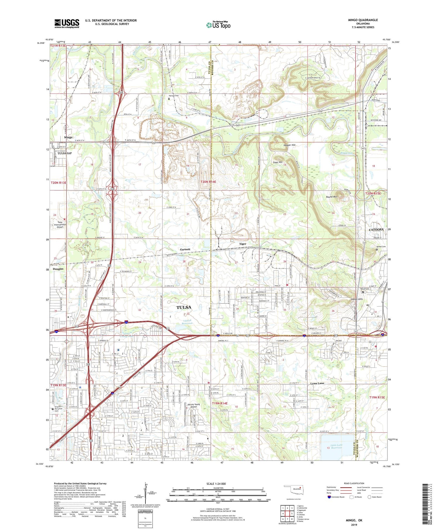
2019 topographic map quadrangle Mingo in the state of Oklahoma. Scale: 1:24000. Based on the newly updated USGS 7.5' US Topo map series, this map is in the following counties: Tulsa, Rogers, Wagoner. The map contains contour data, water features, and other items you are used to seeing on USGS maps, but also has updated roads and other features. This is the next generation of topographic maps. Printed on high-quality waterproof paper with UV fade-resistant inks.
Quads adjacent to this one:
West: Tulsa
Northwest: Sperry
North: Collinsville
Northeast: Sageeyah
East: Catoosa
Southeast: Oneta
South: Broken Arrow
Southwest: Jenks
Contains the following named places: Airport Free Will Baptist Church, Berean Fellowship, Bethany Baptist Church, Briarglen Square, Brookhaven Christian Church, Brookhaven Hospital, Catoosa Fire Department Station 2, Catoosa High School, Catoosa Post Office, Catoosa Primary School, CC's Cosmetology College, Central Cathedral, Cherokee Shopping Center, Christview Christian Church, Church of God, Church of the God of the Apostolic, City of Catoosa, Cooley Lake, Cooper Elementary School, Crosstown Shopping Center, Denbo Cemetery, Disney Elementary School, Duck Cemetery, East Central High School, East Central Junior High School, East Tulsa Bible Chapel, Eastern Village, Eastland Apostolic Tabernacle, Eastland Assembly, Eastland Baptist Church, Eastland Hills Christian Church, Eastland Mall, Eastland Plaza, Eastside Baptist Church, Eastwood Baptist Church, Elm Creek, Executive Mall, Faith Center, Family History Center, Family Life Ministries Church, Family Worship Center, First Foursquare Gospel Church, Garnett, Garnett Road Baptist Church, Glory Bound Full Gospel Church, Goat Hill, Grayson Perryman Cemetery, Harlow Cemetery, Harvey Young Airport, Hooper Hill, Indian Hills, Indian Hills Country Club, J W Sam Elementary School, Jubilee Worship Center, Kerr Elementary School, Kingdom Hall-Jehovahs Witness Church, KVOO-AM (Tulsa), Lewis and Clark Elementary School, Lincoln Christian School, Lynn Lane, Lynn Lane Reservoir, Marina Shopping Center, Mayo Demonstration Elementary School, Memorial Bible Church, Mill Creek, Mingo, Mingo Creek, Newcomer International School, Northeast Plaza Shopping Center, Oklahoma Highway Patrol Troop B, Oknoname 143018 Dam, Oknoname 143018 Reservoir, Peary Elementary School, Phillips Theological Seminary, Plainview Church, Plaza Family Shopping Center, Ranch Creek, Restoration Church, Rolling Hills Fire Department, Rolling Hills Shopping Center, Rosewood Shopping Center, Rosewood Wesleyan Church, Round Mountain, Saint Marks United Methodist Church, Saint Pauls Church of the Nazarene, Saint Thomas More Catholic Church, Sandburg Elementary School, Southeast Freewill Baptist Church, Tam-Bao Buddhist Temple, Terry Crist Ministries Church, The Church of Jesus Christ of Latter Day Saints, Tiger, Today Bible and You Church, Town and Country Christian Church, Truth Shall Triumph Church, Tulsa Chinese Christian Church, Tulsa Fire Department Headquarters, Tulsa Fire Department Station 30, Tulsa Fire Department Station 31, Tulsa Fire Marshal, Tulsa Police Department Mingo Valley Division, Tulsa Spoken Word Tabernacle Church, University of Phoenix Tulsa Campus, Vettie Cooley Dam, Vettie Cooley Lake, Vietnamese Community Saint Joseph Church, Wells Middle School, Wright Christian Academy, ZIP Codes: 74108, 74116, 74128, 74129


