MyTopo
Moore Oklahoma US Topo Map
Couldn't load pickup availability
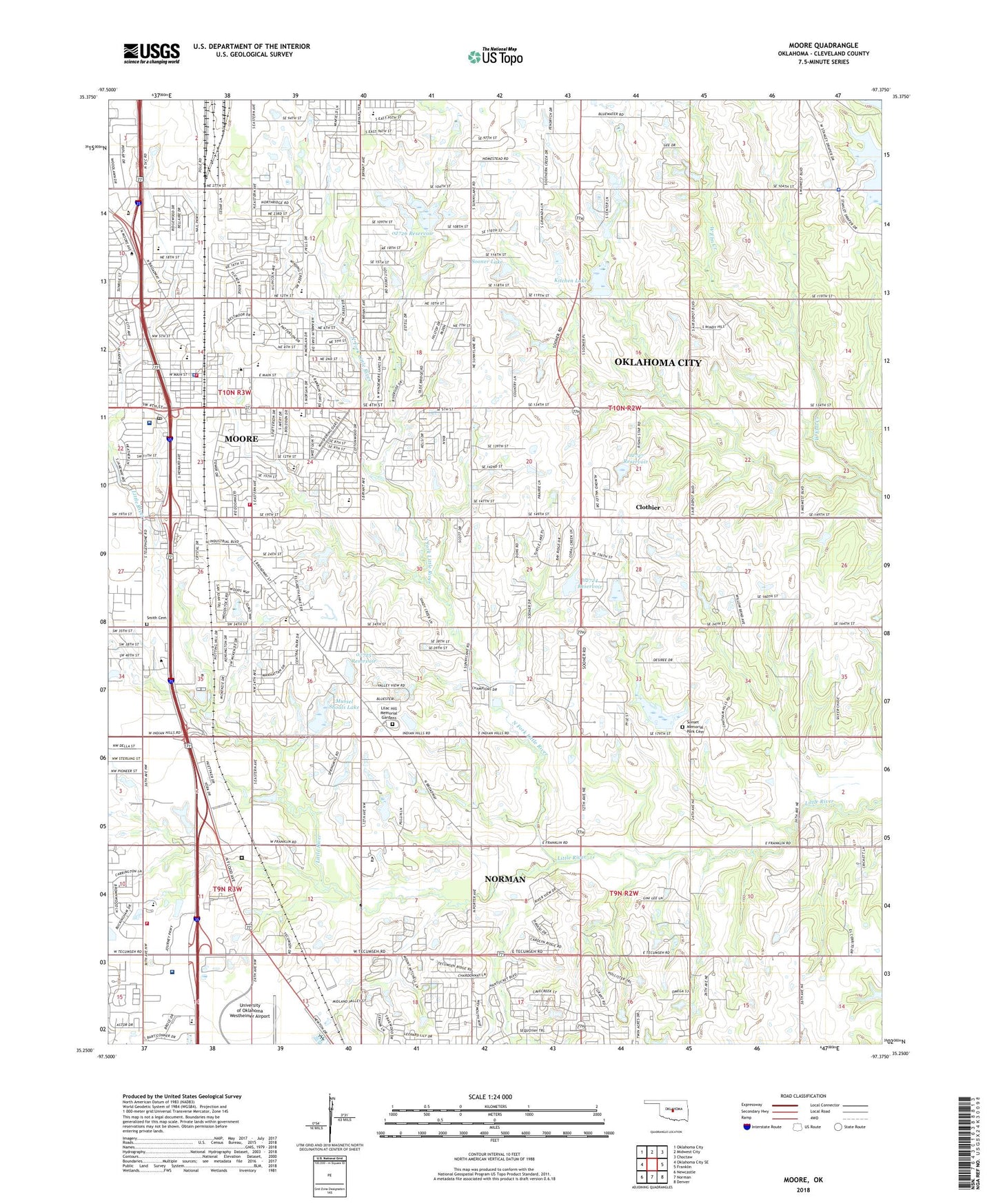
2018 topographic map quadrangle Moore in the state of Oklahoma. Scale: 1:24000. Based on the newly updated USGS 7.5' US Topo map series, this map is in the following counties: Cleveland. The map contains contour data, water features, and other items you are used to seeing on USGS maps, but also has updated roads and other features. This is the next generation of topographic maps. Printed on high-quality waterproof paper with UV fade-resistant inks.
Quads adjacent to this one:
West: Oklahoma City SE
Northwest: Oklahoma City
North: Midwest City
Northeast: Choctaw
East: Franklin
Southeast: Denver
South: Norman
Southwest: Newcastle
Contains the following named places: All Saints Catholic School, Apostolic Lighthouse Church, Apple Creek Elementary School, Bible Church, Blue Lakes Church, Broadmoore Elementary School, Brookside Chapel, Bryant Elementary School, Calvary Church, Calvary Tabernacle, Central Elementary School, Central Junior High School, Central Mid-High, Centre of America Shopping Center, Church of Christ, Church of Christ-Moore Central, City Church of Moore, City of Moore, City of Moore Shopping Center, Clothier, Clothier Oil Field, Community Chapel, Community Christian School, Community Park, Covenant Life Assembly Church, Daystar Community Church, East Hills School, Eastern Avenue Baptist Church, Estates Park, F Dewayne Beggs Detention Center, First Baptist Church of Moore, First Christian Church-Moore, First Church of God of Moore, First Freewill Baptist Church, First Presbyterian Church, First United Methodist Church, George Lynn Cross Academy, Highland Baptist Church, Highland Church, Highland East Junior High School, Hollywood Corners, Kitchen Dam, Kitchen Lake, KTOK-AM (Oklahoma City), Lazy Day Dam, Lazy Day Lake, Lilac Hill Memorial Gardens, Mary Lee Clark United Methodist Church, Midwest Regional Emergency Medical Services Moore, Moore, Moore Airpark, Moore Baptist Temple, Moore Christian School, Moore Church of the Nazarene, Moore Fire Department Station 1, Moore Fire Department Station 3, Moore High School, Moore Norman Technology Center, Moore Police Department, Moore Post Office, Moore Seventh Day Adventist Church, Morgan Road Freewill Baptist Church, Municipal Hospital, Mussel Shoals Dam, Mussel Shoals Lake, Nelson Park Shopping Center, Norman Regional Health System Moore Medical Center, North Cleveland Division, North Fork Little River, Northmoor Elementary School, Oklahoma City Police Dept, Oklahoma Health Academy, Oklahoma School of Photography, Oknoname 02724 Dam, Oknoname 02724 Reservoir, Oknoname 02725 Dam, Oknoname 02725 Reservoir, Oknoname 02726 Dam, Oknoname 02726 Reservoir, Oknoname 02727 Dam, Oknoname 02727 Reservoir, Olivet Baptist Church-Norman, Platt College - Moore Campus, Randall University, Ross Dress for Less Center, Smith Cemetery, Sooner Lake, Sooner Shopping Center, South Moore Oil Field, Southgate Pentecostal-Holiness Church, Southmoor Assembly of God Church, Southmoor Church, Suburban Baptist Church, Sunset Memorial Park Cemetery, Trinity Baptist Church-Moore, Union Baptist Church, United Pentecostal Church, Winding Creek Elementary School, ZIP Code: 73160