MyTopo
Gladstone Oregon US Topo Map
Couldn't load pickup availability
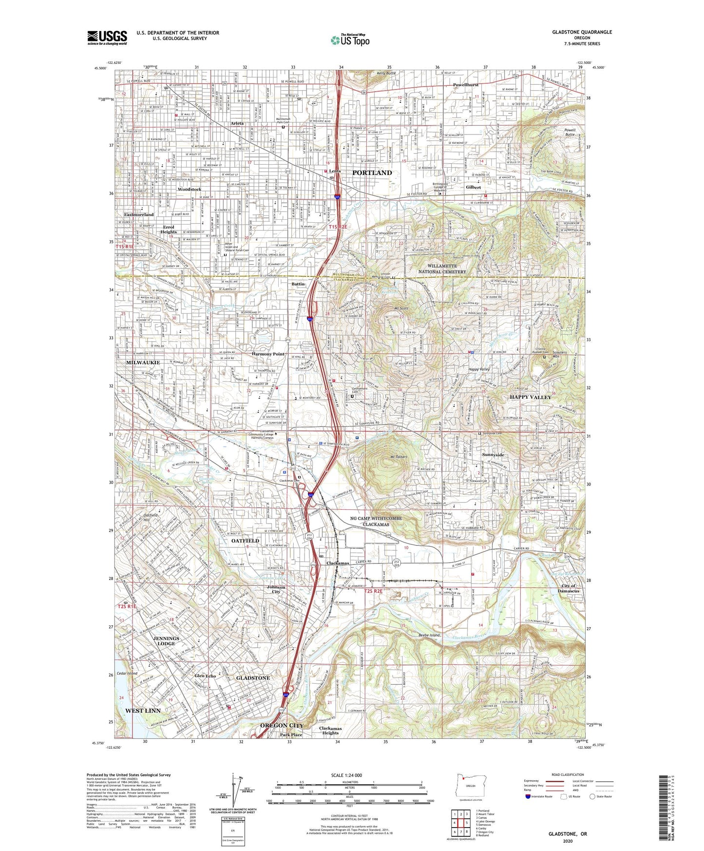
2024 topographic map quadrangle Gladstone in the state of Oregon. Scale: 1:24000. Based on the newly updated USGS 7.5' US Topo map series, this map is in the following counties: Clackamas, Multnomah. The map contains contour data, water features, and other items you are used to seeing on USGS maps, but also has updated roads and other features. This is the next generation of topographic maps. Printed on high-quality waterproof paper with UV fade-resistant inks.
Quads adjacent to this one:
West: Lake Oswego
Northwest: Portland
North: Mount Tabor
Northeast: Camas
East: Damascus
Southeast: Redland
South: Oregon City
Southwest: Canby
This map covers the same area as the classic USGS quad with code o45122d5.
Contains the following named places: Alder Creek, Alder Creek Middle School, Alma Myra Park, Altamont Park, Ann-Toni Schreiber Park, Ardenwald Elementary School, Arleta, Arleta Elementary School, Arnaud, Ashdale, Ashley Meadows Park, Barlow School, Battin, Battin School, Beebe Island, Beggars Tick Wildlife Refuge, Bell, Bellrose, Berkeley City Park, Bilquist Elementary School, Bloomington City Park, Brentwood City Park, Brentwood Park, Brookside Park, Brookwild, Camas Creek, Camp Withycombe, Campbell Elementary School, Carver County Boat Ramp, Charles Ames Memorial City Park, Chautauqua Lake, City of Gladstone, City of Happy Valley, City of Johnson City, City of Milwaukie, Clackamas, Clackamas Cemetery, Clackamas Census Designated Place, Clackamas Promenade Shopping Center, Clackamas River Water Disinfection System, Clackamas Town Center Park and Ride, Clackamas Town Center Shopping Center, Clackamas Town Center Transit Center, Clatsop Butte City Park, Concord Elementary School, Cow Creek, Creston City Park, Creston Elementary School, Cristilla Pioneer Cemetery, Cross Memorial City Park, Cub Airport, Dean Creek, Dierickx Field, Earl Boyles City Park, Earl Boyles Elementary School, Eastmoreland, Eastport Plaza Shopping Center, Eastridge City Park, Ed Benedict City Park, Eda Creek, Errol, Errol Heights, Errol Heights City Park, Essex City Park, Evangelical Center Conference Grounds, Fern Ridge, Firland Parkway, Flavel City Park, Furnberg Park, Gates Park Property, Gentemann Property, Gethsemani Cemetery, Gilbert, Gilbert Heights City Park, Gilbert Heights Elementary School, Gilbert Park Elementary School, Gilbert Primary Park, Gilbert Station, Gladstone, Gladstone Park Seventh Day Adventist Camp, Gladstone Station, Glen Echo, Glen Echo Wetlands, Glenwood City Park, Happy Valley, Happy Valley Airport, Happy Valley City Park, Happy Valley Elementary School, Happy Valley Nature Park, Harmony, Harmony Point, Harmony Road Neighborhood Park, Harmony School, Harney City Park, Heddie Notz Park, Hereford, High Rocks City Park, Holy Family School, Ickes School, Jennings Lodge, Jennings Lodge Census Designated Place, Jennings Lodge Elementary School, Johnson City, Johnson City Park, Johnson Creek, Johnson Lake, Kaiser Sunnyside Medical Center, Kellogg Middle School, Kelly Butte, Kelly Butte Natural Area, Kelly Elementary School, Kendall, Kern City Park, Kern Park Christian Church Park and Ride, Keser Israel and Shaarie Torah Cemetery, KEX-AM, King Road Center Shopping Center, Kingsley D Bundy City Park, Kirkpatrick, KMJK-FM, KUPL-AM, KUPL-FM, KYXI-AM, Laidlaw, Lane Middle School, Laurelwood City Park, Leach Botanical Garden, Lent Elementary School, Lents, Lents Junction, Lents Park, Lewelling Elementary School Tennis Courts, Lewis Elementary School, Lincoln Memorial Cemetery, Lithgow Creek, Lot Whitcomb Elementary School, Lovawalla Spring, Lower Powell Butte Floodplain, Luther, Luther School, Marysville Elementary School, Mason Airstrip, Max Patterson Memorial City Park, Meldrum Bar City Park, Meldrum Bar Park Boat Ramp, Mill Park, Minthorn North Natural Area, Mount Scott, Mount Scott City Park, Mount Scott Creek, Mount Talbert, Mount Talbert Nature Park, Multnomah Park Cemetery, North Clackamas Aquatic Park, North Clackamas Central Park, North Clackamas County Water Commission, Northwest Clackamas Division, Oak Hill Airstrip, Oatfield, Oatfield Census Designated Place, Oatfield Hill, Olson Wetlands, Our Lady of Sorrows School, Outlook, Park Place, Pauling Academy of Integrated Sciences, Phillips Creek, Pilgrim Lutheran Church Park and Ride, Powell Butte, Powell Villa Center Shopping Center, PTC/Abernethy Lane Trail, Ramapo, Raymond City Park, Ridgegate City Park, Rivergreens Golf Course, Riverside County Park, Riverside County Park Boat Ramp, Rock Creek, Rock Creek Corner, Ross Center Shopping Center, Rothe, Saint Anthony's School, Saint Ignatius Parish School, Saint Peters School, Salty Acres Wetlands, Sara Hite Rose Garden, Scottie Creek, Scouters Mountain, Sherwood Forest Tot Lot, Sieben Park, South Fork Water Board, South Fork Water Board Treatment Plant, Southern Lites Park, Springwater Corridor Trail, Springwater on the Willamette, Stanley, Stocker City Park, Summerfield Park, Sunnyside, Sunnyside Cemetery, Sunnyside Census Designated Place, Sycamore, Tenino Property, Terrace Trails Park, The Milwaukie Center, Tideman Johnson City Park, Top O' Scott Golf Course, Tri - City Service District, Tri - City Service District Biomass Facility, Valley View City Park, Veterans Creek, Veterans Dam, Veterans Reservoir, Village Green Park, Walker Stadium, Water Tower Park, Watson, Whitman Elementary School, Wichita Station, Willamette National Cemetery, Wilson, Woodmere Elementary School, Woodstock, Woodstock City Park, Woodstock Elementary School, Woodstock Super Center Shopping Center, Youth Adventure Park, ZIP Codes: 97015, 97027, 97086, 97206, 97222, 97236, 97266, 97267