
MyTopo
Grants Pass Oregon US Topo Map
Couldn't load pickup availability
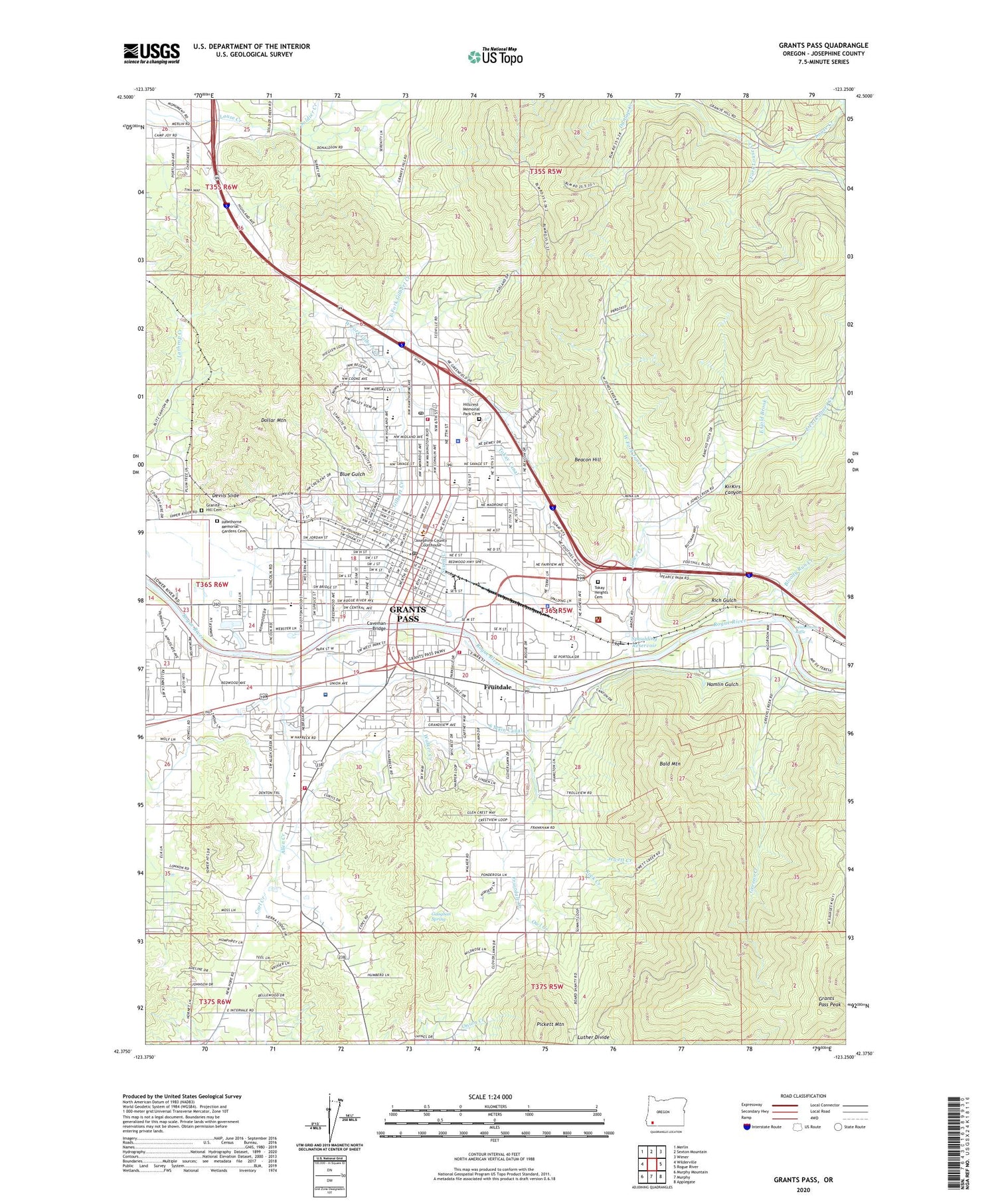
2020 topographic map quadrangle Grants Pass in the state of Oregon. Scale: 1:24000. Based on the newly updated USGS 7.5' US Topo map series, this map is in the following counties: Josephine. The map contains contour data, water features, and other items you are used to seeing on USGS maps, but also has updated roads and other features. This is the next generation of topographic maps. Printed on high-quality waterproof paper with UV fade-resistant inks.
Quads adjacent to this one:
West: Wilderville
Northwest: Merlin
North: Sexton Mountain
Northeast: Wimer
East: Rogue River
Southeast: Applegate
South: Murphy
Southwest: Murphy Mountain
Contains the following named places: Allen Creek, Allen Dale Elementary School, American Medical Response, Asante Health Three Rivers Community Hospital Blood Bank, Asante Three Rivers Medical Center, Baker Park Boat Ramp, Bald Mountain, Barnstormers Theatre, Beacon Hill, Bloody Run Creek, Blue Gulch, Brighton Academy, Bulb, Bureau of Land Management Grants Pass Interagency Office, Carl Creek, Cathedral Hills County Park, Caveman Bridge, Chinook County Park, Chinook Park Boat Ramp, City of Grants Pass, Columbia Mine, Croxton Pioneer Memorial Park, Department of Motor Vehicles Grants Pass, Devils Slide, Dimmick School, Dollar Mountain, East Fork Gilbert Creek, East Fork Jones Creek, East Gold Brook, Fruitdale, Fruitdale Census Designated Place, Fruitdale Creek, Fruitdale Elementary School, Galice Ranger Station, Gaughan Spring, George H Eckstein Park, Gilbert Creek, Granite, Granite Hill, Granite Hill Cemetery, Granite Hill Mine, Granite Hill Post Office, Grants Pass, Grants Pass City Hall, Grants Pass Country Club, Grants Pass DCU, Grants Pass Department of Public Safety Police Department, Grants Pass Fire and Rescue Operations Division Station 1 Headquarters, Grants Pass Fire and Rescue Operations Division Station 2, Grants Pass High School, Grants Pass Museum of Art, Grants Pass Peak, Grants Pass Performing Arts Center, Grants Pass Post Office, Grants Pass Public Works, Grants Pass Water Treatment Plant, Greens Creek, Greyhound Station, Hamlin Gulch, Harbeck-Fruitdale Census Designated Place, Hawthorne Memorial Gardens Cemetery, Highland Elementary School, Highline Canal, Hillcrest Memorial Park Cemetery, Historic Rogue Theatre, Ida Mine, Inland Helicopters Heliport, Jewett Creek, Jewett Mine, Jones Creek, Josephine Community Library, Josephine Community Transit, Josephine County Adult Jail, Josephine County Community Corrections, Josephine County Fairgrounds, Josephine County Fairgrounds Racetrack, Josephine County Juvenile Justice Center, Josephine County Public Health Department, Josephine County Public Works, Josephine County Sheriff's Office, Josephine Memorial Hospital Emergency Heliport, Josphine County Circuit Courthouse, KAGI-AM, KAJO-AM, KFMJ-FM, KirKirs Canyon, Lawnridge Park, Lincoln Elementary School, Luther Divide, Newbridge High School, North Fork Louse Creek, North Middle School, Oak Grove School, One Eleven Evelyn Theatre, Oregon State Police Department Grants Pass, Oregon Youth Authority - Rogue Valley Youth Correctional Facility, Owl Creek, Parkside Elementary School, Pickett Mountain, Redjacket Mine, Rich Gulch, Riverside Elementary School, Riverside Park, Riverside Park Boat Launch, Rock Creek, Roseburg Lumber Company Airstrip, Rural / Metro Fire Department Fleet Management Facility, Rural / Metro Fire Department Station 1, Sanders, Schmidt House Museum, Siskiyou National Forest Headquarters, Skunk Creek, Soldier Creek, South Fork Louse Creek, South Highline Canal, South Main Canal, South Middle School, Spaulding Reservoir, Spring, Tokay Canal, Tokay Heights Cemetery, Tom Pearce County Park, Tussing Park, United Parcel Service Wastewater Treatment Facility, United States Forest Service Wild Rivers Ranger District, Walker Creek, West Fork Gilbert Creek, West Fork Jones Creek, West Gold Brook, Westholm Park, Winterbottom Riffle


