MyTopo
Roseburg East Oregon US Topo Map
Couldn't load pickup availability
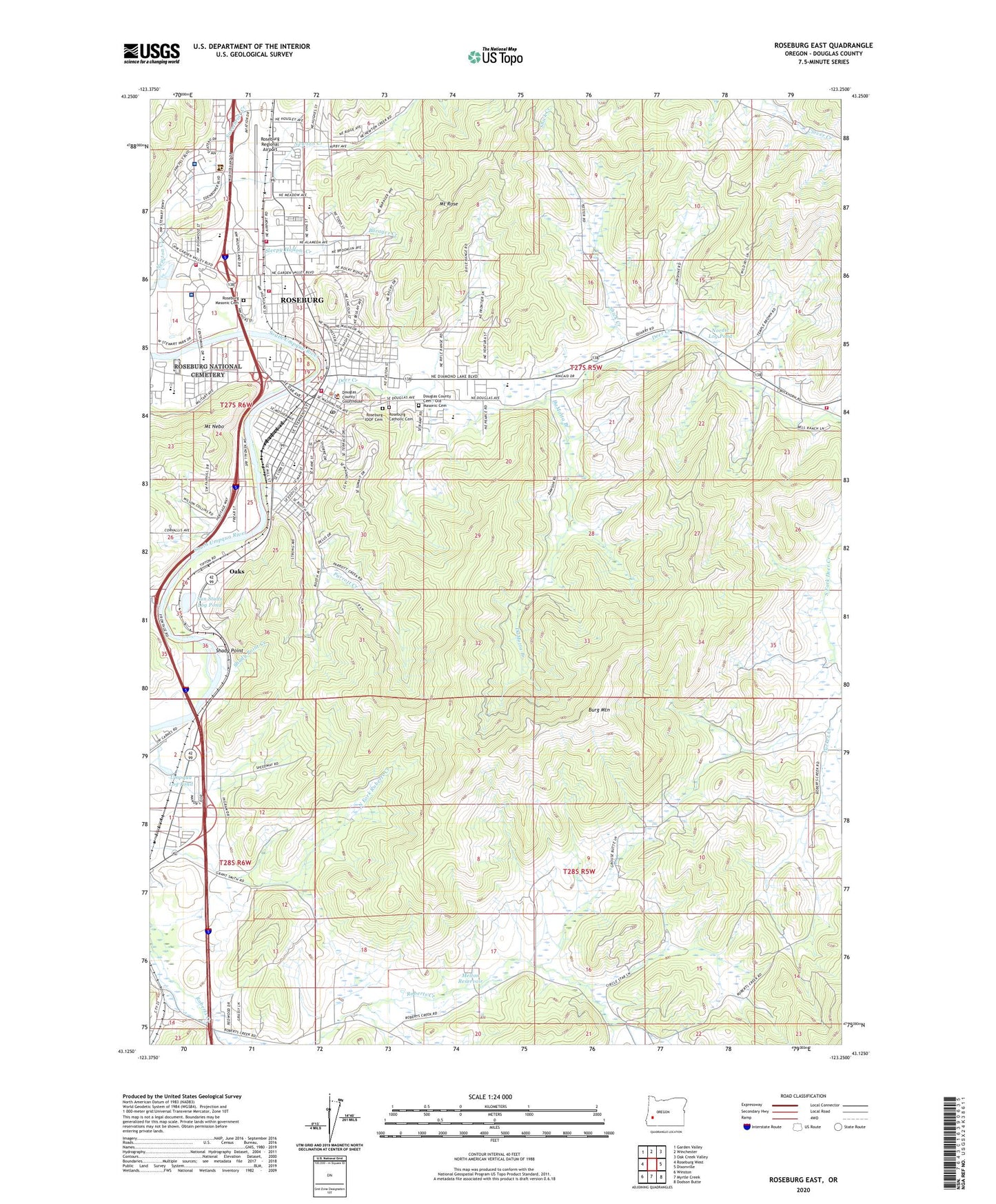
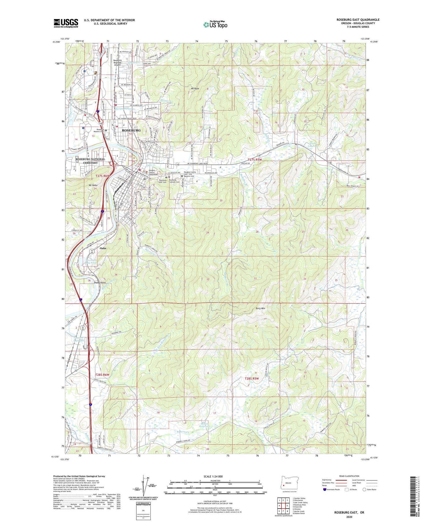
2020 topographic map quadrangle Roseburg East in the state of Oregon. Scale: 1:24000. Based on the newly updated USGS 7.5' US Topo map series, this map is in the following counties: Douglas. The map contains contour data, water features, and other items you are used to seeing on USGS maps, but also has updated roads and other features. This is the next generation of topographic maps. Printed on high-quality waterproof paper with UV fade-resistant inks.
Quads adjacent to this one:
West: Roseburg West
Northwest: Garden Valley
North: Winchester
Northeast: Oak Creek Valley
East: Dixonville
Southeast: Dodson Butte
South: Myrtle Creek
Southwest: Winston
Contains the following named places: Alderbrook Post Office, Barager Creek, Barnes, Betty Long Unruh Theatre, Beulah Park, Bureau of Land Management Roseburg District Office, Burg Mountain, Carnes, Charles S Gardiner Park, City of Roseburg, Cobb School, Commercial Street Park, DaMotta Branch, Deer Creek, Deer Creek Park, Department of Motor Vehicles Roseburg, Douglas Community Hospital, Douglas County Cemetery - Old Masonic Cemetery, Douglas County Civil and Circuit Courthouse, Douglas County Fairgrounds Complex Amphitheatre, Douglas County Fairigrounds Complex and Speedway, Douglas County Fire District 2 Dixonville Station 1, Douglas County Fire District 2 Headquarters, Douglas County Home, Douglas County Justice Building, Douglas County Library, Douglas County Museum of History and Natural History, Douglas County Public Health Department, Douglas County Public Works, Douglas County Sheriff's Office Roseburg, Douglas County Speedway, Douglas Forest Protective Association Central Unit Headquarters, Eagles Park, Eastwood Elementary School, Eastwood Park, Elk Island, Fairgrounds Boat Launch, Fir Grove Elementary School, Fir Grove Section of Stewart Park, Gaddis Park, Glengary, Green, Greyhound Station, Iverson Log Ponds, John C Fremont Middle School, Joseph Lane Middle School, KPIC-TV, KQEN-AM, KRSB-FM, Lane House, Laurelwood Park, Melton Reservoir, Mercy Medical Center, Micelli Park, Mount Nebo, Mount Rose, New Beginnings Christian Assembly, Nordic Log Pond, North Umpqua Sewage Disposal Plant, Oaks, Oregon State Police Department Roseburg Patrol, Ornoname 12 Dam, Ornoname 8 Dam, Park Lake, Parrott Creek, Parrott Creek Park, Perkins Log Pond, Perkins Log Pond Dam, Phoenix School, Red Cross Blood Donor Center, Red Cross Blood Services, Red Cross Umpqua South Coast District, River Front Park, Riverside Park, Riverside School, Roberts Creek, Roberts Creek School, Rose Elementary School, Roseburg, Roseburg Catholic Cemetery, Roseburg City Hall, Roseburg Division, Roseburg Fire Department Station 1, Roseburg Fire Department Station 3, Roseburg High School, Roseburg IOOF Cemetery, Roseburg Masonic Cemetery, Roseburg Municipal Court, Roseburg Municipal Golf Course, Roseburg National Cemetery, Roseburg Police Department, Roseburg Post Office, Roseburg Public Works, Roseburg Regional Airport, Roseburg Skate Park, Saint Joseph Parish School, Shady, Shady Point, Shady Point Creek, Shick Creek, Sleepy Hollow Creek, South Knoll Park, Stewart City Park Bandshell, Stewart Park, Stewart Park Wildlife Pond, Sun Studs Log Pond, Sunshine Park, Templin Beach Park, Templin Beach Roseburg City Park Ramp, Thompson Park, Umpqua Log Pond, Umpqua National Forest Headquarters, Umpqua Park, Veterans Affairs Roseburg Healthcare System Roseburg Medical Center, Vine Street Baptist Church, Warner School, Willis Park, Youngs Bay Lumber Company Dam, Youngs Bay Lumber Company Pond