
MyTopo
Butler Pennsylvania US Topo Map
Couldn't load pickup availability
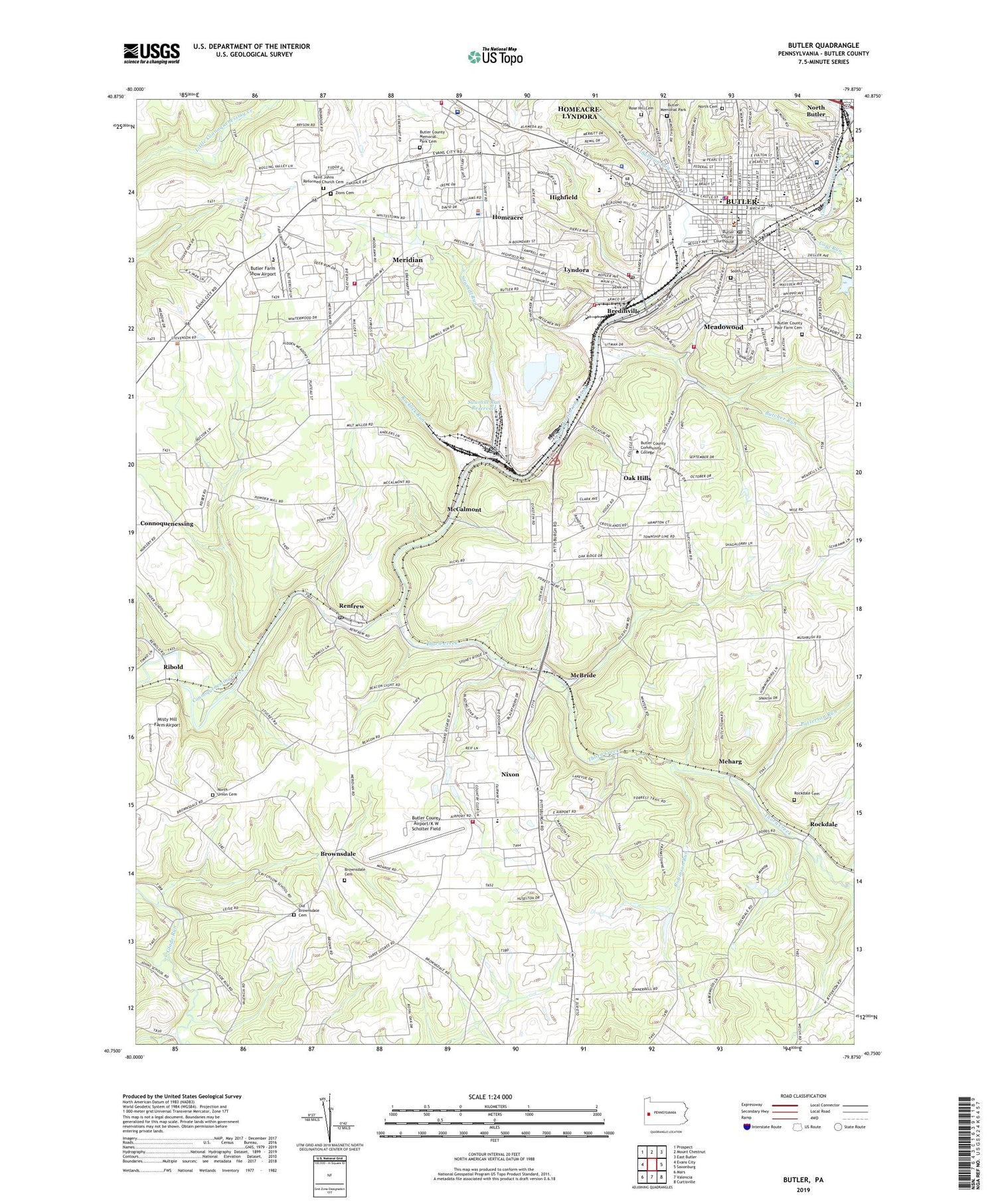
2019 topographic map quadrangle Butler in the state of Pennsylvania. Scale: 1:24000. Based on the newly updated USGS 7.5' US Topo map series, this map is in the following counties: Butler. The map contains contour data, water features, and other items you are used to seeing on USGS maps, but also has updated roads and other features. This is the next generation of topographic maps. Printed on high-quality waterproof paper with UV fade-resistant inks.
Quads adjacent to this one:
West: Evans City
Northwest: Prospect
North: Mount Chestnut
Northeast: East Butler
East: Saxonburg
Southeast: Curtisville
South: Valencia
Southwest: Mars
Contains the following named places: Ak Steel Plant Protection Fire Station, Bredinville, Brownsdale, Brownsdale Cemetery, Butcher Run, Butler, Butler Ambulance Service, Butler Area Senior High School, Butler Bureau of Fire Station 1, Butler Community College Public Safety Training Center, Butler County Airport/K W Scholter Field, Butler County Memorial Park Cemetery, Butler County Poor Farm Cemetery, Butler County Sheriff's Office, Butler Farm Show Airport, Butler Mall, Butler Memorial Hospital, Butler Memorial Park, Butler Police Department, Butler Post Office, Butler Township Police Department, Calmwood Airport, Camp Redwing, Center Avenue Elementary School, Central West End School, Childrens Rehabilitation Center, City of Butler, Coal Run, Conleys Golf Course, Connoquenessing Volunteer Fire Station, Department of Veterans Affairs Fire Station, Deshon Veterans Administration Hospital, Emily Brittain Elementary School, Highfield, Homeacre, Homeacre-Lyndora Census Designated Place, Institute Hill School, Johns School, Krendale Golf Course, Lakevue North Golf Course, Life Flight 4 Butler County Airport Ambulance Service, Lyndora, Lyndora Elementary School, Lyndora Post Office, Lyndora Volunteer Fire Department Station 4, McBride, McBride Station, McCalmont, McKee School, McQuistion Elementary School, Meadowood, Meadowood Census Designated Place, Meharg, Meridian, Meridian Census Designated Place, Meridian Community Volunteer Fire Department Station 3, Meridian Elementary School, Misty Hill Farm Airport, Nixon, Nixon Census Designated Place, Nixon School, North Butler, North Cemetery, North Union Cemetery, North Union Church, Northwest Elementary School, Oak Hills, Oak Hills Census Designated Place, Oak Hills Golf Course, Old Brownsdale Cemetery, Patterson Run, Penn Elementary School, Penn Township Police Department, Penn Township Volunteer Fire Department Station 11, Pennsylvania State Police Troop D Headquarters and Butler Station, Renfrew, Renfrew Post Office, Renfrew Station, Ribold, Robinson Run, Rockdale, Rockdale Cemetery, Rocklick Run, Rose Hill Cemetery, Saint Johns Church, Saint Johns Reformed Church Cemetery, Saint Michaels School, Saint Pauls School, Sawmill Run, Sawmill Run Dam, Sawmill Run Reservoir, South Butler Volunteer Fire Department Station 7, South Cemetery, Sullivan Run, Suncrest Golf Course, Thorn Creek, Township of Butler, Township of Penn, Veteran Affairs Butler Healthcare Center Hospital, West End School, White Church, Zions Cemetery, ZIP Codes: 16045, 16053


