MyTopo
Prospect Pennsylvania US Topo Map
Couldn't load pickup availability
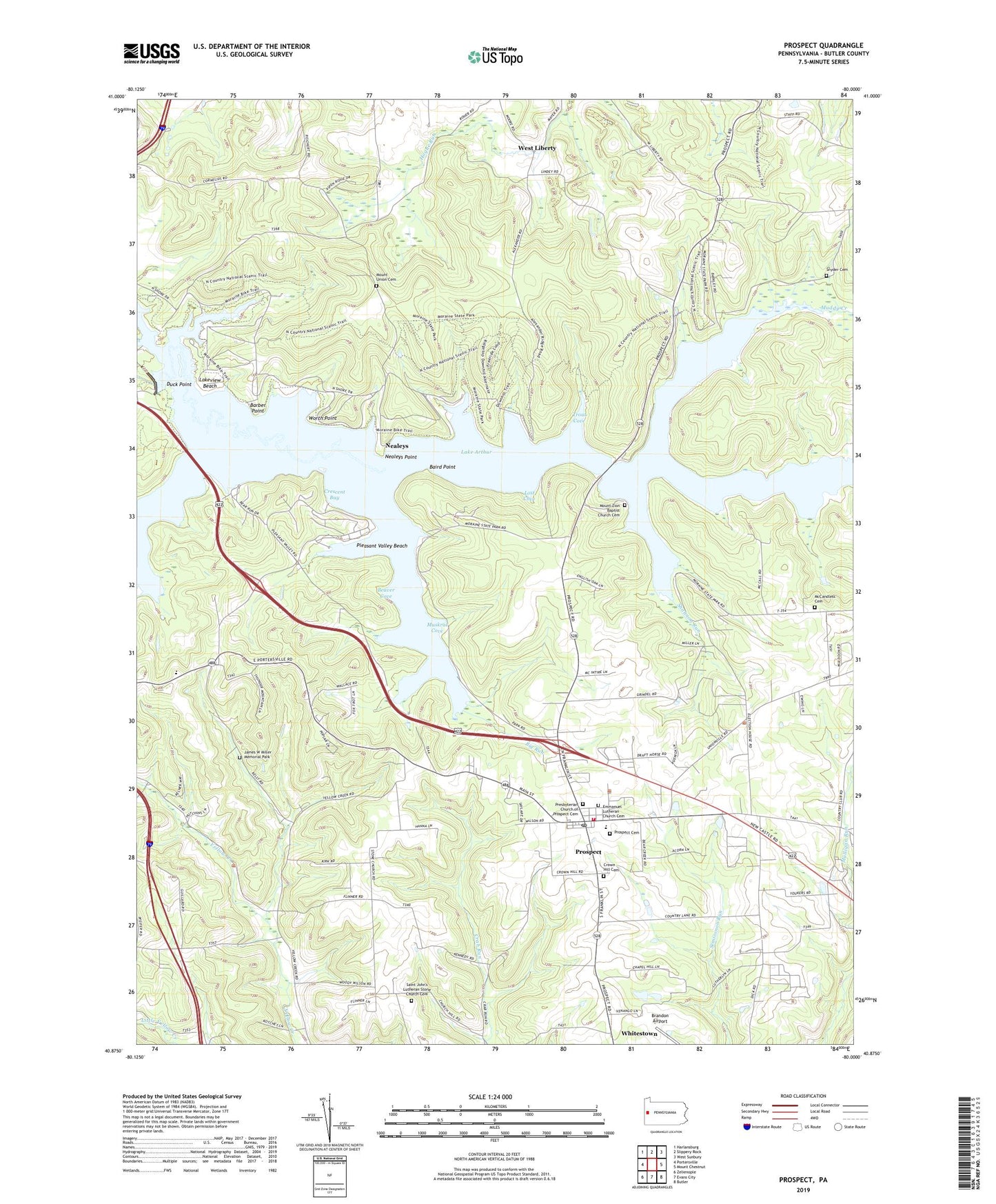
2023 topographic map quadrangle Prospect in the state of Pennsylvania. Scale: 1:24000. Based on the newly updated USGS 7.5' US Topo map series, this map is in the following counties: Butler. The map contains contour data, water features, and other items you are used to seeing on USGS maps, but also has updated roads and other features. This is the next generation of topographic maps. Printed on high-quality waterproof paper with UV fade-resistant inks.
Quads adjacent to this one:
West: Portersville
Northwest: Harlansburg
North: Slippery Rock
Northeast: West Sunbury
East: Mount Chestnut
Southeast: Butler
South: Evans City
Southwest: Zelienople
This map covers the same area as the classic USGS quad with code o40080h1.
Contains the following named places: Baird Point, Barber Point, Bear Run, Beaver Cove, Big Run, Borough of Prospect, Brandon Airport, Bunker Hill School, Camp Lutherlyn, Crescent Bay, Crown Hill Cemetery, Dick School, Duck Point, Emmanuel Lutheran Church Cemetery, Hickory Corner, Isle, James W Miller Memorial Park, Lake Arthur, Lakeview Beach, Lost Cove, McCandless Cemetery, McKelvay School, Mile Run School, Moraine State Park Dam, Mount Union Cemetery, Mount Union Church, Mount Zion Baptist Church Cemetery, Mount Zion Church, Muskrat Cove, Nealeys, Nealeys Point, Oak Grove School, Pleasant Valley Beach, Pleasant Valley School, Presbyterian Church of Prospect Cemetery, Prospect, Prospect Borough - Franklin Township Volunteer Fire Department Station 13, Prospect Borough Elementary School, Prospect Cemetery, Prospect Post Office, Saint John's Lutheran Stone Church Cemetery, Saint Johns Stone Church, Shannon Run, Snyder Cemetery, Swamp Run, Township of Brady, Township of Franklin, Township of Muddy Creek, Trout Cove, Whitestown, Worth Point, ZIP Code: 16052