
MyTopo
Carbondale Pennsylvania US Topo Map
Couldn't load pickup availability
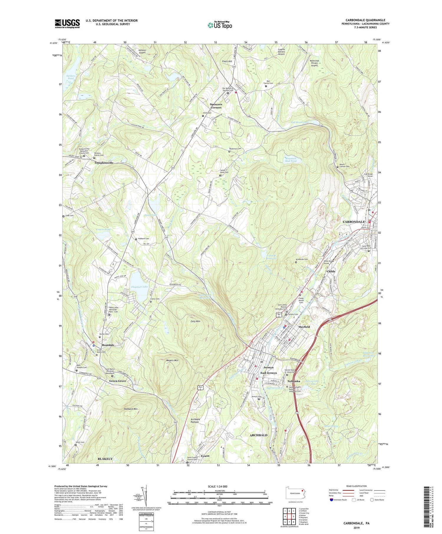
2019 topographic map quadrangle Carbondale in the state of Pennsylvania. Scale: 1:24000. Based on the newly updated USGS 7.5' US Topo map series, this map is in the following counties: Lackawanna. The map contains contour data, water features, and other items you are used to seeing on USGS maps, but also has updated roads and other features. This is the next generation of topographic maps. Printed on high-quality waterproof paper with UV fade-resistant inks.
Quads adjacent to this one:
West: Dalton
Northwest: Lenoxville
North: Clifford
Northeast: Forest City
East: Waymart
Southeast: Lake Ariel
South: Olyphant
Southwest: Scranton
Contains the following named places: Archbald Pothole, Archbald Pothole State Park, Artisan Volunteer Fire Company, Ashlawn Airport, Aylesworth Creek, Aylesworth Creek Dam, Aylesworth Creek Lake, Aylesworth Park, Ball Family Cemetery, Black Diamond Hose Company, Borough of Archbald, Borough of Jermyn, Borough of Mayfield, Brookside Cemetery, Brown Cemetery, Callender Gap Creek, Calvary Cemetery, Carbondale, Carbondale Area Junior / Senior High School, Carbondale Fire Department - Mitchell Hose Company Station 51 - 1, Carbondale Police Department, Carbondale Post Office, Carey Cemetery, Cary Mountain, Chapman Lake, Chapman Lake Post Office, Childs, Childs Jewish Cemetery, City of Carbondale, Coal Brook Tunnel, Coleman Dam, Cook Cemetery, Corpus Christi Church, Cottage Hose Ambulance Station 51, Crystal Fire Company Station 58 - 1, East Jermyn, Eaton Breaker, Eaton Colliery, Edgerton Reservoir, Erie Breaker, Eynon Shopping Center, Fall Brook, Fall Brook Lake, Fall Brook Mines, Finch Cemetery, Finch Hill, Finch Hill Church, Graves Pond, Green Grove, Greenfield High School, Greenfield Township Volunteer Fire Company Station 24, Heart Lake, Homestead Golf Course, Hubbard Cemetery, Hubbard Mountain, Jermyn, Jermyn Cemetery, Jermyn Post Office, Jermyn Shaft Breaker, Lakeland Junior Senior High School, Lees Creek, Lees Creek Dam, Malinchak Private Airport, Mayfield, Mayfield Hose Company Station 59 - 1, Meredith Creek, Meredith Hose Company Station 60, Merli-Sarnoski County Park, Meyers Mountain, Montdale, Moosic Power Company Mills, Mount Carmel Cemetery, Mountain Mud Pond, Murrins Mines, Nebraska, O and W Reservoir, Our Mother of Sorrows Cemetery, Powderly Creek, Powell, Racket Brook, Romar Plaza, Rush Brook, Rush Brook Reservoir, Sacred Heart of Jesus Cemetery, Saint Francis Church Cemetery, Saint Johns Russian Orthodox Cemetery, Saint Josephs Cemetery, Saint Mary's Cemetery and Mausoleum, Saint Michael's Russian Orthodox Cemetery, Saint Rose of Lima Cemetery, Sandy Bank Cemetery, Scott High School, Scott Township Hose Company Station 36, Scott Valley Cemetery, Shove Creek, Sicklers Pond, Smith Cemetery, Spencers Corners, Spruce Swamp, State Game Lands Number 307, Sugermans Shopping Plaza, Tomkins Family Cemetery, Tompkinsville, Tompkinsville Methodist Church Cemetery, Township of Carbondale, Township of Fell, Township of Greenfield, Township of Scott, Valley View Memorial Park - Cemetery, Valley View Trailer Park, Wedeman Cemetery, White Bridge Tunnel, Whitmore Hose Company, William Walker Hose Company Station 59 - 3, ZIP Codes: 18403, 18407, 18433, 18447


