MyTopo
Ephrata Pennsylvania US Topo Map
Couldn't load pickup availability
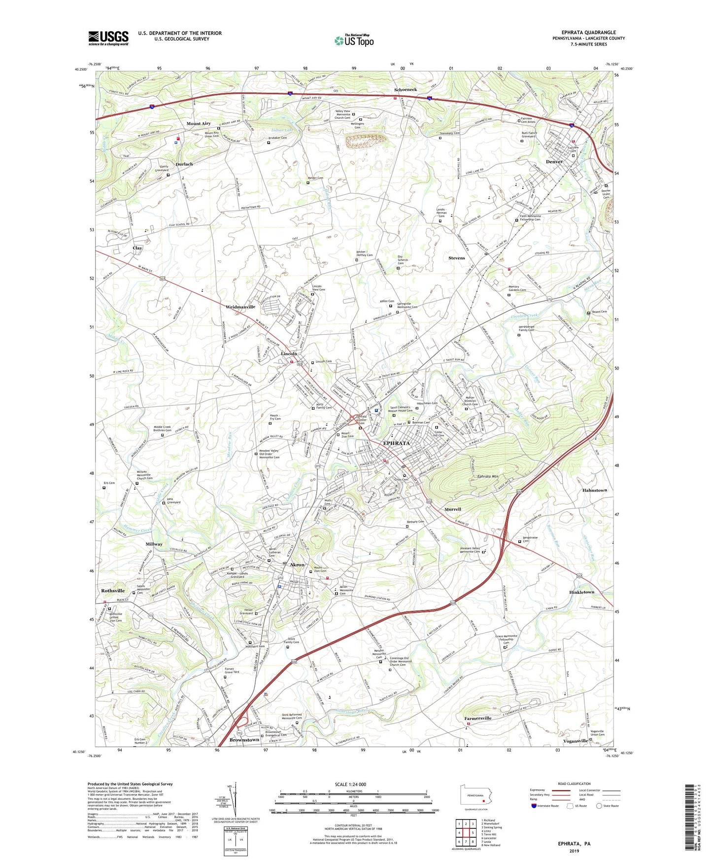
2019 topographic map quadrangle Ephrata in the state of Pennsylvania. Scale: 1:24000. Based on the newly updated USGS 7.5' US Topo map series, this map is in the following counties: Lancaster. The map contains contour data, water features, and other items you are used to seeing on USGS maps, but also has updated roads and other features. This is the next generation of topographic maps. Printed on high-quality waterproof paper with UV fade-resistant inks.
Quads adjacent to this one:
West: Lititz
Northwest: Richland
North: Womelsdorf
Northeast: Sinking Spring
East: Terre Hill
Southeast: New Holland
South: Leola
Southwest: Lancaster
Contains the following named places: Akron, Akron Borough Police Department, Akron Elementary School, Akron Lutheran Cemetery, Akron Mennonite Cemetery, Akron Post Office, Akron Volunteer Fire Company Station 12, Becker / Heffley Cemetery, Bergstrasse Cemetery, Bergstrasse School, Bethany Cemetery, Bethany School, Bitzer School, Borough of Akron, Borough of Denver, Borough of Ephrata, Bowman Cemetery, Bowman Run, Brossman Fruit Farm, Brownstown Census Designated Place, Brownstown Evangelical Cemetery, Brownstown Vocational Technical School, Brubaker Cemetery, Callaco Farm, Cedar Hill Cemetery, Clay Census Designated Place, Clearview Farms, Cocalico Union School, Conestoga Church, Conestoga Old Order Mennonite Church Cemetery, Conestoga View School, Coover Run, Crystal Springs Farm, Denver, Denver Fire Company 1 Station 13, Denver Post Office, Denver Union Cemetery, Diamond Springs, Durlach, Durlach - Mount Airy Fire Company Station 14, Durlach Post Office, Durlach School, Eberly Graveyard, Eby Scherck Cemetery, Ephrata, Ephrata Area Rescue Services, Ephrata Cloister, Ephrata Cloister Cemetery, Ephrata Community Ambulance - Station 1, Ephrata Community Hospital, Ephrata Mountain, Ephrata Pioneer Fire Company Station 15, Ephrata Police Department, Ephrata Post Office, Ephrata School, Erb Cemetery, F P Farm, Fairmount, Fairview Cemetery, Fairview Cemetery Annex, Faith Mennonite Fellowship Cemetery, Farmersville, Farmersville Census Designated Place, Farmersville Fire Company Station 35, Farmersville Post Office, Fetter School, Fishing Creek Park, Forney Grave Yard, Fulton School, Gensemer Run, Glenda Dairy, Glenwood Farms, Grace Mennonite Fellowship Cemetery, Gross Cemetery, Hammer Creek, Hans Graf School, Hauck - Fry Cemetery, Heiser Graveyard, Hershberger Family Cemetery, Hess Graveyard, Hibschman Cemetery, Hillview Farms, Hinkletown Post Office, Indian Lake, Indian Run, Indian Run Farm, Indiantown Church, Indiantown Mennonite Cemetery, Jerusalem Church, Keller Cemetery, Kemper - Landis Graveyard, Kurtz Family Cemetery, Landis - Herman Cemetery, Le - Ann Valley Farm, Legion Park, Lincoln, Lincoln Cemetery, Lincoln Elementary School, Lincoln Fire Company 1 Station 16, Lincoln Post Office, Lincoln View Cemetery, Little Cocalico Creek, Lloyd H Roland Memorial Park, Martin Poultry Farm, Meadow Run, Meadow Valley Church, Meadow Valley Old Order Mennonite Cemetery, Mellingers Cemetery, Mellingers Church, Memory Gardens Cemetery, Metzer Cemetery, Metzler Mennonite Cemetery, Metzler School, Middle Creek, Middle Creek Brethren Cemetery, Middle Creek Church, Middle Creek Search and Rescue Station 94, Millport School, Millway, Millway Mennonite Church Cemetery, Millway Post Office, Millway Run, Mohler Brethren Church Cemetery, Mohler Run, Mohlers Church, Mount Airy, Mount Airy School, Mount Airy Union Cemetery, Mount Zion Cemetery, Murrell, Newtown, Nissley Acres Park, Northern Lancaster County Regional Police Department, Pleasant Hill School, Pleasant Valley Mennonite Cemetery, Reams Cemetery, Reamstown Post Office, Rothsville Census Designated Place, Rothsville United Zion Cemetery, Rothsville Volunteer Fire Department Station 24, Ruth Family Graveyard, Saint Clement's Mission House Cemetery, Saint Clements School, Saint Pauls Church, Salem Methodist Cemetery, Scarecrow Hill Community Farm, Schoeneck, Schoeneck Census Designated Place, Schoeneck Elementary School, Schoeneck Fire Company Station 19, Schoeneck Park, Schoeneck Post Office, Schoeneck Quarry, Seminole, Shirk Reformed Mennonite Cemetery, Shirks Church, Snyder Community Park, Springville, Springville Mennonite Cemetery, Steinmetz Cemetery, Steinmetz Church, Stevens, Stevens Census Designated Place, Stevens Fire Company 1 Station 17 - 3, Stevens Post Office, Stock Family Cemetery, Stony Run, Sunnyside School, Township of Clay, Township of Ephrata, Township of West Earl, Valley View Mennonite Church Cemetery, Voganville Union Cemetery, Washington School, Weaver Dairy, Weaver Farms, Weidmanville, West Earl Township Police Department, West View Golf Course, WGSA-AM (Ephrata), WIOV-FM (Ephrata), Wohlfahrt Cemetery, Wolfs Cemetery, Wood Corners School, Zartman Farms, Zion Church, ZIP Codes: 17501, 17517, 17522, 17578