MyTopo
Lancaster Pennsylvania US Topo Map
Couldn't load pickup availability
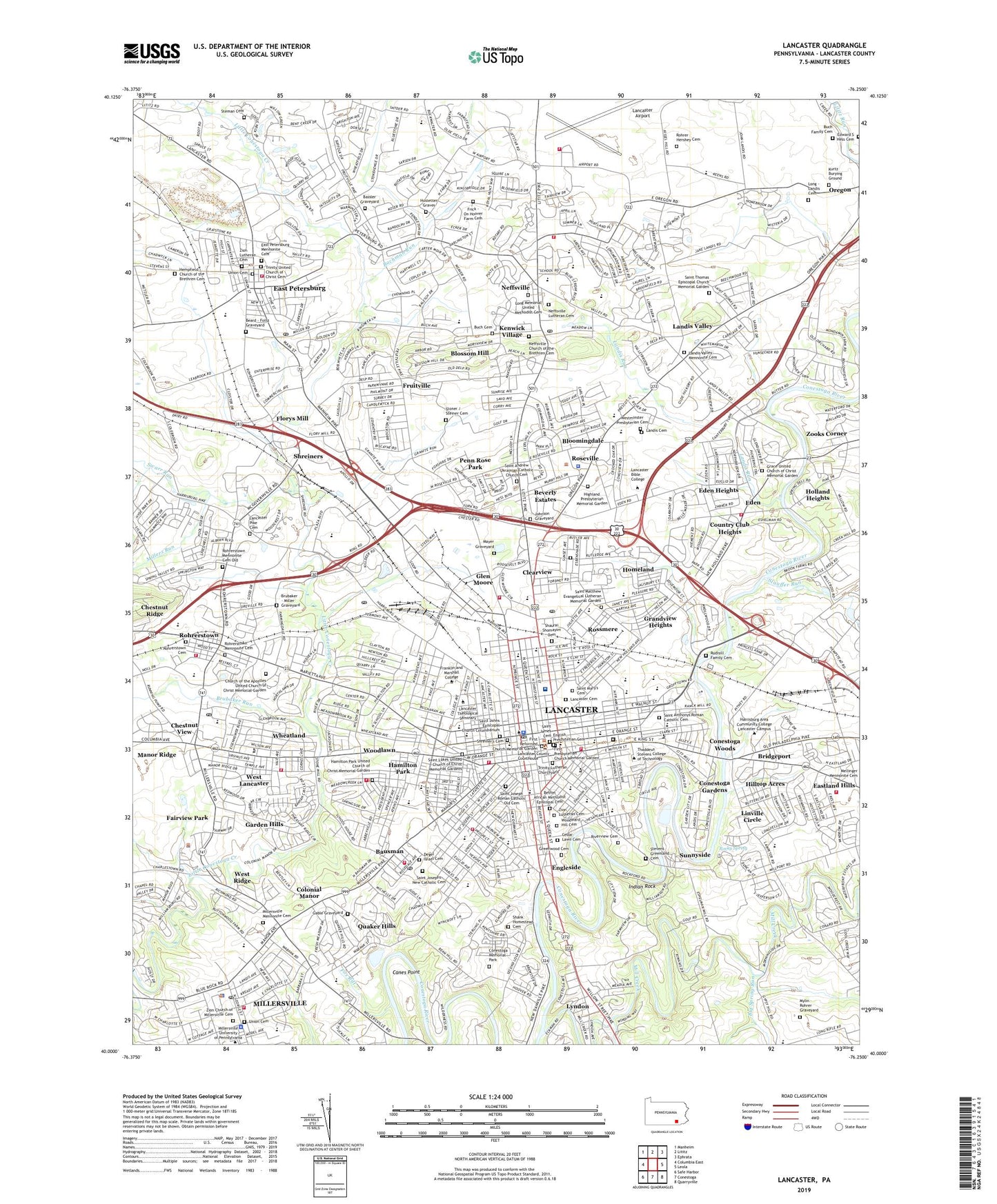
2023 topographic map quadrangle Lancaster in the state of Pennsylvania. Scale: 1:24000. Based on the newly updated USGS 7.5' US Topo map series, this map is in the following counties: Lancaster. The map contains contour data, water features, and other items you are used to seeing on USGS maps, but also has updated roads and other features. This is the next generation of topographic maps. Printed on high-quality waterproof paper with UV fade-resistant inks.
Quads adjacent to this one:
West: Columbia East
Northwest: Manheim
North: Lititz
Northeast: Ephrata
East: Leola
Southeast: Quarryville
South: Conestoga
Southwest: Safe Harbor
This map covers the same area as the classic USGS quad with code o40076a3.
Contains the following named places: Appel Infirmary, Bachman Run, Bassler Graveyard, Bausman, Beard - Foltz Graveyard, Benners Quarry, Bethel African Methodist Episcopal Cemetery, Beverly Estates, Big Spring Run, Binkley and Ober Quarry, Bloomingdale, Blossom Hill, Borough of East Petersburg, Borough of Millersville, Brandon Park, Bridgeport, Brooklawn, Brubaker - Miller Graveyard, Brubaker Run, Buch Cemetery, Buch Family Cemetery, Buchanan Park, Buchmiller Park, Burrow School, Canes Point, Catholic High School Stadium, Cedar Lawn Cemetery, Chestnut Ridge, Chestnut View, Church of the Apostles United Church of Christ Memorial Garden, City of Lancaster, Clearview, Colin Field, Colonial Manor, Conestoga Country Club, Conestoga Gardens, Conestoga Memorial Park, Conestoga Pines Park, Conestoga Woods, Country Club Heights, Crystal Park, Degel Israel Cemetery, East Petersburg, East Petersburg Civic Grounds, East Petersburg Mennonite Cemetery, East Petersburg Quarry, Eastland Hills, Eden, Eden Heights, Edward S Hess Cemetery, Eichholtz School, Elizabeth Jenkins Elementary School, Engleside, English Presbyterian Cemetery, Fairview Park, First Presbyterian Church Memorial Gardens, First Reformed Church Memorial Garden, Florys Mill, Fox Rill, Foxshire Plaza, Franklin and Marshall Athletic Field, Franklin and Marshall College, Franklin Family Farms, Frick - On Hoover Farm Cemetery, Fruitville, Fruitville Quarry, Gable Graveyard, Garden Hills, Glen Moore, Golden Triangle Shopping Center, Grace United Church of Christ Memorial Garden, Grandview Heights, Greenfield Station, Greenwood Cemetery, Groffs Corner, Habecker Airport, Hambright School, Hamilton Bank Heliport, Hamilton Park, Hamilton Park United Church of Christ Memorial Garden, Hand Junior High School, Haupt School, Hemenz Golf Course, Hempfield Church of the Brethren Cemetery, Higbee School, Highland Presbyterian Memorial Garden, Hilltop Acres, Holland Heights, Homeland, Hostetter Graves, Indian Rock, James Buchanan Elementary School, Johnson Graveyard, Kenwick Village, Kiwanis Park, Kurtz Burying Ground, LaFayette Elementary School, Lancaster, Lancaster Airport, Lancaster Cemetery, Lancaster Christian Junior High School, Lancaster Church of the Brethren Memorial Garden, Lancaster Country Club, Lancaster Country Day School, Lancaster County Park, Lancaster General Hospital, Lancaster General Hospital Heliport, Lancaster Jaycee Park, Lancaster Municipal Park, Lancaster Osteopathic Hospital, Lancaster Pike Cemetery, Lancaster Plaza, Lancaster Regional Medical Center, Lancaster Shopping Center, Lancaster Square, Landis Cemetery, Landis Farm, Landis Run, Landis Valley, Landis Valley Mennonite Cemetery, Leabrook Farm, Lincoln Junior High School, Linville Circle, Long - Landis Cemetery, Long Memorial United Methodist Cemetery, Longs Park, Lyndon, Manheim Township Community Park, Manor Joint High School, Manor Ridge, Manor Township Community Park, Martin Greider Park, Mayer Graveyard, McCaskey High School, McGovernsville, Media Heights Golf Club, Mifflin School, Mill Creek, Millers Run, Millersville Borough Park, Millersville Mennonite Cemetery, Musser Park, Mylin - Rohrer Graveyard, Neffsville, Neffsville Church of the Brethren Cemetery, Neffsville Lutheran Cemetery, Noll Airport, Northeast Neighborhood Park, Olde Hickory Shopping Center, Oreville, Overlook, Overlook Golf Course, Overlook Park, Parkview Plaza, Penn Rose Park, Quaker Hills, RCA-Lancaster Heliport, Reservoir Park, Reynolds Junior High School, Riverview Cemetery, Rocky Spring, Rocky Springs Park, Rohrer Hershey Cemetery, Rohrerstown, Rohrerstown Cemetery, Rohrerstown Elementary School, Rohrerstown Mennonite Cemetery, Rohrerstown Mennonite Cemetery Old, Roseville, Rossmere, Rudisill Family Cemetery, Sacred Heart of Jesus School, Saint Andrew Ukrainian Catholic Church Cemetery, Saint Anthonys Roman Catholic Cemetery, Saint Anthonys School, Saint James Cemetery, Saint Johns Episcopal Church Columbarium, Saint Joseph Roman Catholic Old Cemetery, Saint Joseph School, Saint Josephs New Catholic Cemetery, Saint Lukes United Church of Christ Memorial Gardens, Saint Mary's Cemetery, Saint Matthew Evangelical Lutheran Memorial Garden, Saint Thomas Episcopal Church Memorial Garden, School Lane Hills, Shaeffer School, Shank Homestead Cemetery, Shaurai Shomayim Cemetery, Shreiners, Shreiner's Cemetery, Sixth Ward Park, Skyline Park, South Duke Street Mall, South End Park, Sponaugle-Williamson Field, Stauffer Park, Stauffer Run, Steman Cemetery, Stevens Elementary School, Stevens Greenland Cemetery, Stevens Industrial School, Stone Mill Plaza, Stoner / Steiner Cemetery, Sunnyside, Swarr Run, Thomson Heliport, Township of Lancaster, Township of Manheim, Triangle Park, Trinity Lutheran Churchyard, Trinity United Church of Christ Cemetery, Union Cemetery, West Lampeter, West Lancaster, West Ridge, Westminster Presbyterian Cemetery, WFNM-FM (Lancaster), Wheatland, Wheatland Junior High School, Wheatland Shopping Center, Williamson Park, WLAN-AM (Lancaster), WLAN-FM (Lancaster), WLPA-AM (Lancaster), Woodlawn, Woodward Hill Cemetery, WPTG-FM (Lancaster), Wynn Wood Manor, Zion Church of Millersville Cemetery, Zion Lutheran Cemetery, Zooks Corner, ZIP Codes: 17520, 17601, 17603, 17606