MyTopo
Factoryville Pennsylvania US Topo Map
Couldn't load pickup availability
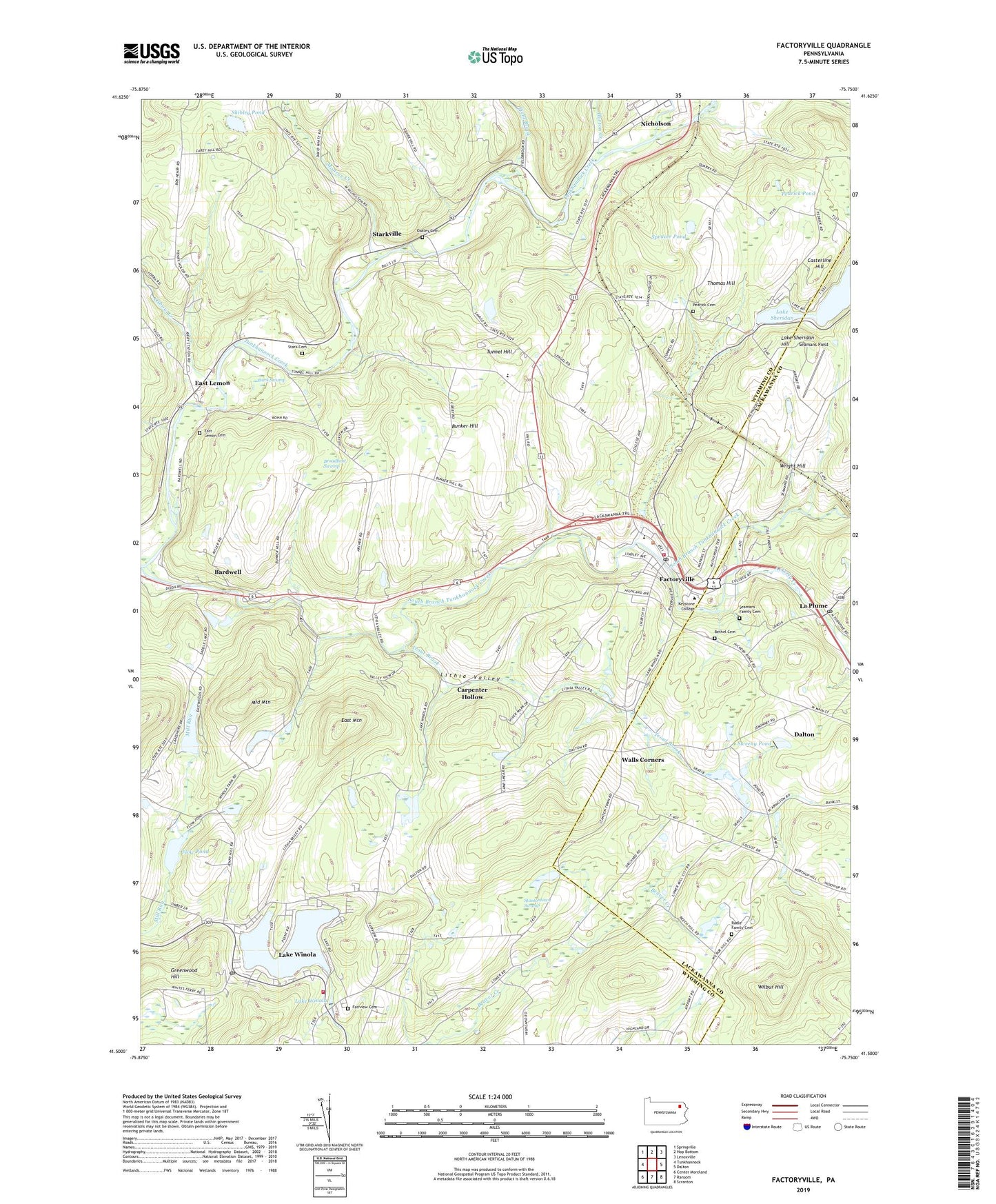
2019 topographic map quadrangle Factoryville in the state of Pennsylvania. Scale: 1:24000. Based on the newly updated USGS 7.5' US Topo map series, this map is in the following counties: Wyoming, Lackawanna. The map contains contour data, water features, and other items you are used to seeing on USGS maps, but also has updated roads and other features. This is the next generation of topographic maps. Printed on high-quality waterproof paper with UV fade-resistant inks.
Quads adjacent to this one:
West: Tunkhannock
Northwest: Springville
North: Hop Bottom
Northeast: Lenoxville
East: Dalton
Southeast: Scranton
South: Ransom
Southwest: Center Moreland
Contains the following named places: Academic Affairs Center, Alumni Hall - Keystone College, Bardwell, Bethel Cemetery, Borough of Factoryville, Broadbent Swamp, Bunker Hill, Capwell Science Hall, Carpenter Hollow, Casterline Hill, Christy Mathewson Field, Community Grove, Creekside Grove, East Lemon, East Lemon Cemetery, East Mountain, Factoryville, Factoryville Fire Company, Factoryville Post Office, Factoryville Station, Fairview Cemetery, Field Brook, Flow Pond, Frear/Reynolds Residence Hall, Gambal Athletic Center, Glen School, Greenwood Hill, Hedgewood House, Hibbard Campus Center, Hillover/Sekol Airport, Hollinshead Residence Hall, Holman Design Studio, Horton Creek, Keystone College, Keystone Commons Residence Hall, Koelsch House, La Plume, La Plume Post Office, Lackawanna Hall, Lake Sheridan, Lake Sheridan Dam, Lake Sheridan Hill, Lake Winola, Lake Winola Census Designated Place, Lake Winola Church, Lake Winola Post Office, Lake Winola Volunteer Fire Company 1, Lithia Valley, Martins Creek, Middle Mountain, Moffat Residence Hall, Monroe Creek, Moore Hall Alumni Garden, Ned Boehm Field, Oakley Cemetery, Oxbow Creek, Patrick Hall, Pedrick Cemetery, Pedrick Pond, Radle Family Cemetery, Ross Dam, Sabiston Hall, Saddle Lake Dam, Seamans Family Cemetery, Seaman's Farmhouse, Seamans Field, Shibley Pond, Sickler Hall, South Branch Tunkhannock Creek, Spencer Pond, Stantontown Swamp, Stark Cemetery, Stark Swamp, Starkville, Sweeney Dam, Sweeny Pond, Tewksbury Residence Hall, The Sugar Shack, Thomas Hill, Township of Clinton, Township of La Plume, Township of Nicholson, Township of Overfield, Township of West Abington, Trout Brook, Tunnel Hill, Tunnel Hill School, Union Chapel, Walls Corners, Wilbur Hill, Winola Mill Pond Dam, Wright Hill, Wyoming Hall, ZIP Codes: 18419, 18625