MyTopo
Hawley Pennsylvania US Topo Map
Couldn't load pickup availability
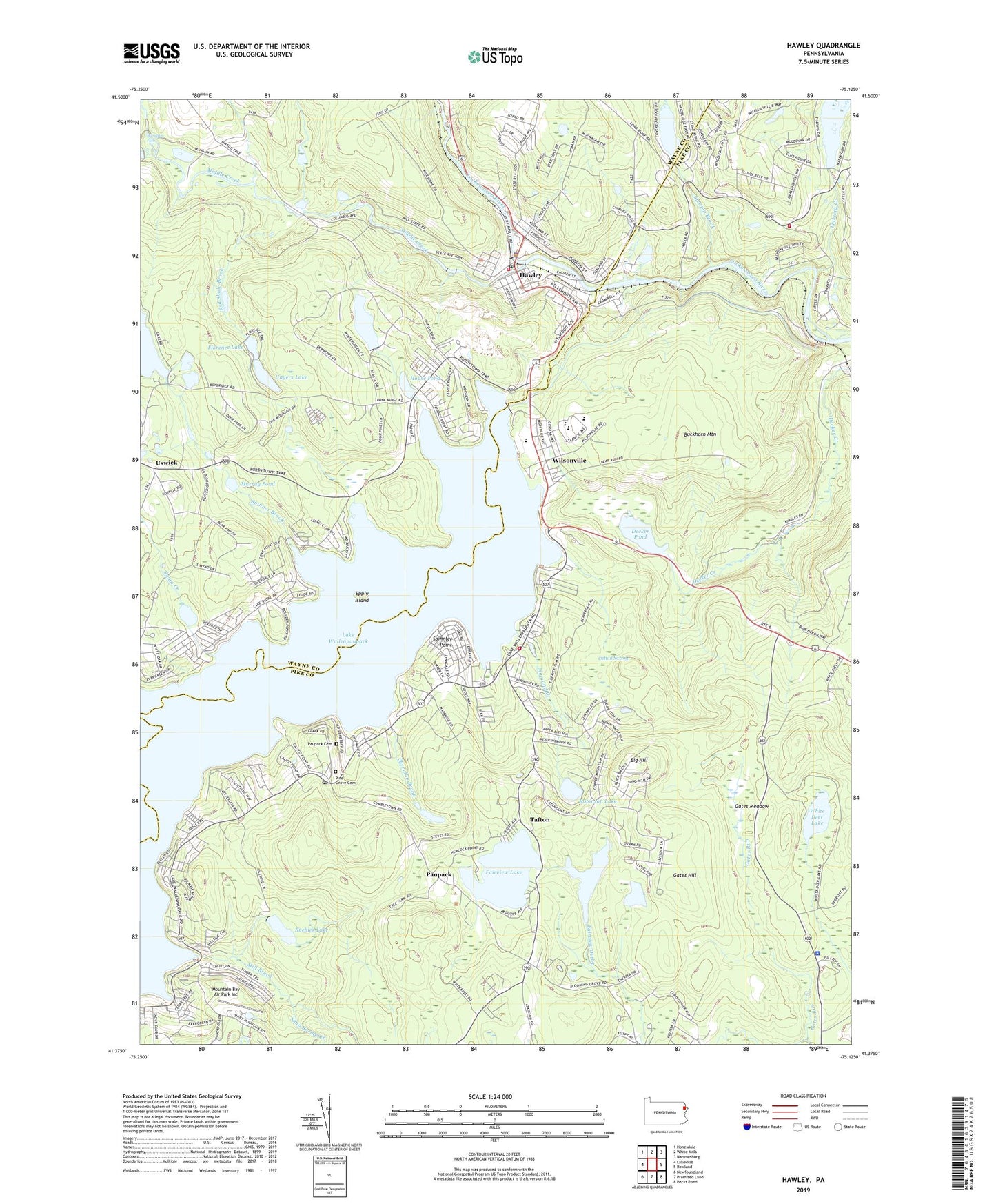
2019 topographic map quadrangle Hawley in the state of Pennsylvania. Scale: 1:24000. Based on the newly updated USGS 7.5' US Topo map series, this map is in the following counties: Pike, Wayne. The map contains contour data, water features, and other items you are used to seeing on USGS maps, but also has updated roads and other features. This is the next generation of topographic maps. Printed on high-quality waterproof paper with UV fade-resistant inks.
Quads adjacent to this one:
West: Lakeville
Northwest: Honesdale
North: White Mills
Northeast: Narrowsburg
East: Rowland
Southeast: Pecks Pond
South: Promised Land
Southwest: Newfoundland
Contains the following named places: Big Hill, Blooming Grove Trail, Borough of Hawley, Buckhorn Mountain, Buehler Dam, Buehler Lake, Caffrey Campground, Camp Brooklyn, Cattail Swamp, Debris Dam Number One, Debris Dam Number Two, Decker Pond, Decker Swamp Dam, Deckers Dam, Diamond Creek, Epply Island, Fairview Lake, Fairview Lake Dam, Florence Lake, Forest Volunteer Fire Department 81, Gates Hill, Gates Meadow, Gates Run, Hawley, Hawley Ambulance and Rescue Company, Hawley Borough Police Department, Hawley Fire Department Station 9, Hawley Post Office, Hawley Water Company Dam, House Pond, House Pond Dam, Kelly Lake Dam, Lake Florence Dam, Lake Wallenpaupack, Lake Wallenpaupack Dam, Lambert Dam, Mainses Pond, Mangan Cove, Melchris Wood, Middle Creek, Middle Creek Quarry, Mill Brook, Mountain Bay Air Park Inc, Murray Pond, Paupack, Paupack Cemetery, Paupack Church, Paupack Post Office, Pennsylvania State Police Troop R Blooming Grove Station, Pine Grove Cemetery, Port Florence Airport, Power Dam, Red Shale Brook, Robinson Lake, Saint Veronicas Church, Sand Spring Creek, Seeley Brook, Seely Dam, Sheridan Brook, Shuman Point, Spinner Brook, Spinnler Point, State Game Lands Number 183, Swamp Brook, Swan Creek, Tafton, Tafton Dike, Tafton Post Office, Tafton Volunteer Fire Company 37, Tanglewood, Tanglewood Ski Area, Tanglwood Ski Area Airport, Tinkwig Creek, Tinkwig Dam, Tinkwig Lake, Township of Palmyra, Ungers Dam, Ungers Lake, Uswick, Valley View Dam, Valley View Lake, Wallenpaupack Area High School, Wallenpaupack Area Middle School, Wallenpaupack Dam, Wallenpaupack Elementary School, Wallenpaupack North Elementary School, Wangaum, Wangaum Falls Dam, Wangum Creek, Wangum Falls, West Hawley, White Deer Lake, White Deer Trail, White School, Whitney Lake Dam, Whitneys Lake Dam, Wilsonville, Wilsonville Recreation Area and Boat Launch, ZIP Codes: 18451, 18464