MyTopo
Lansdale Pennsylvania US Topo Map
Couldn't load pickup availability
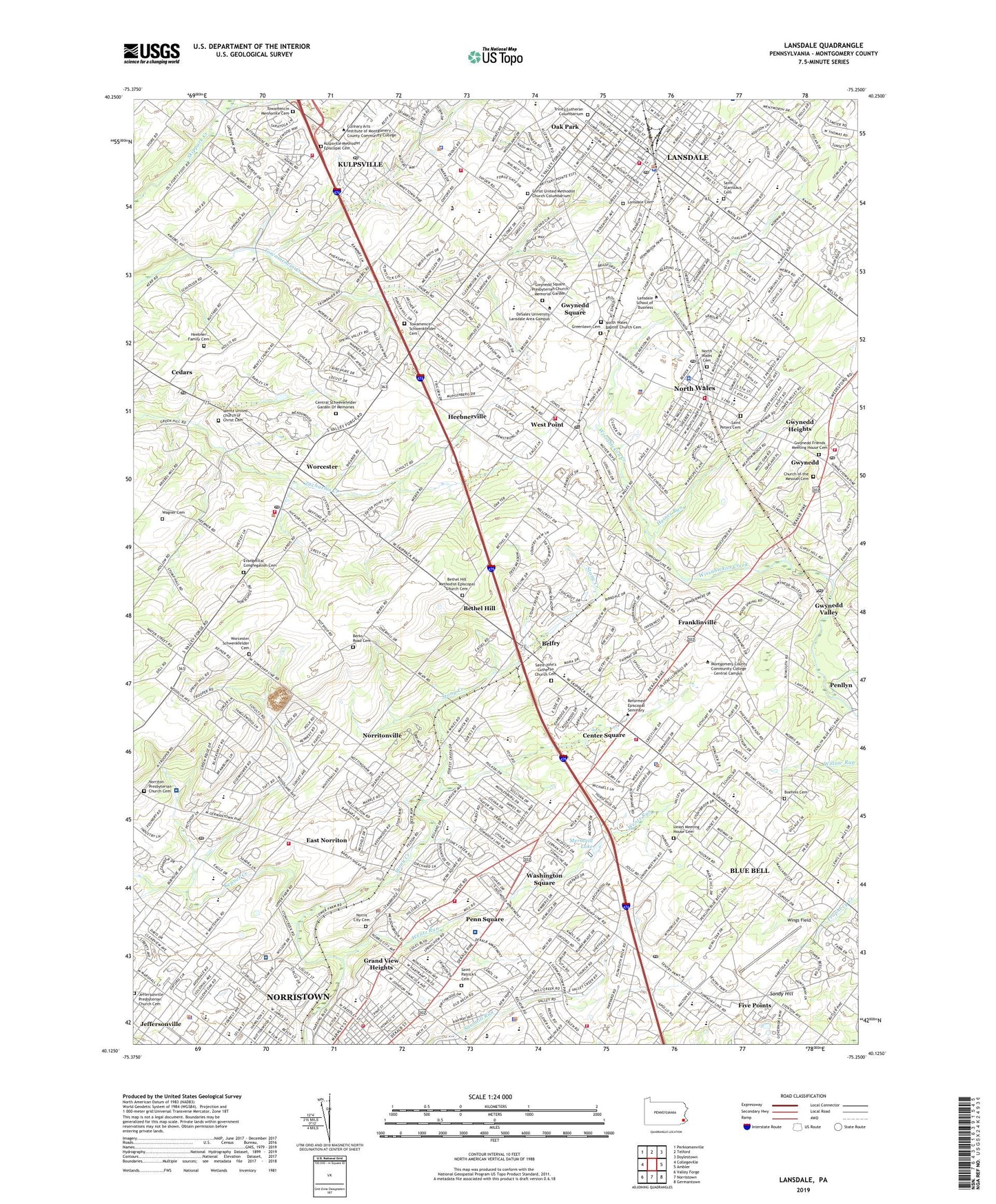
2019 topographic map quadrangle Lansdale in the state of Pennsylvania. Scale: 1:24000. Based on the newly updated USGS 7.5' US Topo map series, this map is in the following counties: Montgomery. The map contains contour data, water features, and other items you are used to seeing on USGS maps, but also has updated roads and other features. This is the next generation of topographic maps. Printed on high-quality waterproof paper with UV fade-resistant inks.
Quads adjacent to this one:
West: Collegeville
Northwest: Perkiomenville
North: Telford
Northeast: Doylestown
East: Ambler
Southeast: Germantown
South: Norristown
Southwest: Valley Forge
Contains the following named places: Acorn, Ager Tract, Astor Shopping Center, Barley Lane, Bayhill, Belfry, Belfry Meadow, Belfry Station, Benesh Dam, Berks Road Cemetery, Bethel Grant, Bethel Hill, Bethel Hill Methodist Episcopal Church Cemetery, Birkdale, Blue Bell, Blue Bell Census Designated Place, Blue Bell Country Club, Blue Bell Crossing, Blue Bell Farms, Blue Bell Gardens, Blue Bell Glenn, Blue Bell Knoll, Blue Bell Office Camp, Blue Bell Road Manor, Blue Bell Square, Boehms Cemetery, Borough of Lansdale, Borough of North Wales, Brittany Pointe Estates, Burnside Oakland Park, Calmensin, Calvert Hurdle Park, Cambridge Knoll, Cardinal Hollow, Cathcart Manor, Cedars, Center Point Village Office Park, Center Square, Center Square Golf Club, Center Square Green, Center Square Plaza Shopping Center, Central Schwenkfelder Garden Of Memories, Chatham Village of Towamencin, Christ United Methodist Church Columbarium, Church of the Messiah Cemetery, Clover Crest, Clover Mall Shopping Center, Coleston, DeKalb Farms, Dekalb Park, East Norriton, East Norriton Census Designated Place, East Norritown Township Park, East Plymouth Valley Park, Elmwood Park, Elmwood Park Zoo, Evangelical Congregation Cemetery, Evansburg State Park, Far-A-Field, Felton Road Industrial Park, Fischers Dam, Fischers Park, Five Points, Foulkeways, Franklinville, Gleneagles, Glengary Highlands, Grand View Heights, Greenlawn Cemetery, Gross Dam, Gwynedd, Gwynedd Acres, Gwynedd Chase, Gwynedd Club, Gwynedd Friends Meeting House Cemetery, Gwynedd Heights, Gwynedd Hill, Gwynedd Square, Gwynedd Square Presbyterian Church Memorial Garden, Gwynedd Valley, Gwynedd Valley Station, Gwynedd Wildlife Preserve, Gwynedd Woods, Haines Run, Harley Corners, Hartranet Station, Heebner Family Cemetery, Heebnerville, Helen Marie Court, Hillcrest Meadows, Hillcrest Plaza Shopping Center, Hollis Hills, Hooverton, Hunter Villa, Imperial Arms, Inglewood, Inglewood Gardens, Inverrary, Jeffersonville, Jeffersonville Presbyterian Church Cemetery, Joe D Airport, Kepner Creek, Kimberly Knoll, Kneedler Station, Kulpsville, Kulpsville Census Designated Place, Kulpsville Methodist Episcopal Cemetery, Lansdale, Lansdale Cemetery, Lansdale Station, Leeds and Northrup Company Heliport, Line Street Park, Logan Square Shopping Center, Madison Ridge, Meadow Wick, Meadowlands Country Club, Meadowlands Manor, Mermaid Estates, Mermaid Lake, Mermaid Swim and Golf Club, Mermaid Swim and Golf Course, Merrybrook, Mews at Blue Bell, Montgomery Commons Shopping Center, Montgomery County, Muirfield, Narcissa, Normandy Farms Estates, Norris City Cemetery, Norris Hills Court, Norristown Farm Park, Norrition Woods, Norriton East, Norriton Presbyterian Church Cemetery, Norriton Square, Norritonville, North Penn Crossing, North Penn Shopping Center, North Wales, North Wales Baptist Church Cemetery, North Wales Cemetery, North Wales Station, Northtowne Shopping Center, Oak Park, Oxford Manor, Packus Airport, Parkside Place Park, Penllyn Knoll, Penn Brooke, Penn Brooke Gardens, Penn Square, Penn Square Shopping Center, Pennbrook Industrial Center, Pennbrook Station, Peter Wentz Farmstead, Peter Wentz Homestead, Plymouth Greene Office Campus, Plymouth Meadows, Plymouth Valley, Regent Manor, Rolling Meadow Estates, Russell-Saylor Airport, Saint John's Lutheran Church Cemetery, Saint Patrick's Cemetery, Saint Peters Cemetery, Saint Stanislaus Cemetery, Sandy Brooke Plaza Shopping Center, Sandy Hill, Saw Mill Dam, Schwenfield Manor, Shady Grove Manor, Sheffield Village, Shinnecock, Springtown, Stuarts Keep, Suburban General Hospital Heliport, Sugarvalley, Sunny Ayr Estates, Sunny Brook Estates, Swede Square Shopping Center, Towamencin Mennonite Cemetery, Towamencin Park, Towamencin Schwenkfelder Cemetery, Towamencin Village, Townline, Township of East Norriton, Township of Towamencin, Township of Upper Gwynedd, Township of Whitpain, Township of Worcester, Trewellyn Creek, Trinity Lutheran Columbarium, Union Meeting House Cemetery, Upper Gwynedd Township Police Heliport, Valentine Estates, Valley Square Campus Industrial Park, Village Circle, Village of Willowbend, Wagner Cemetery, Wales Junction, Washington Square, Welch Village, Wentz Run, Wentz Run Park, Wentz United Church of Christ Cemetery, West Norriton Industrial Park, West Point, West Point Station, Whites Road Park, Whitpain Business and Professional Park, Whitpain Hills, Whitpain Industrial Center, Whitpain Manor, Whitpain Park, Whitpain Shopping Center, Whitpain Woods, WIFI-FM (Philadelphia), Willow Run, Willowyck, Wilson Airport, Winding Brook Estates, Wings Field, Wissahickon Park Gardens, WNAR-AM (Norristown), Woods Golf Center, Woods Golf Course, Worcester, Worcester Golf Course, Worcester Schwenkfelder Cemetery, Wynwood Estates, Yorkshires of Blue Bell, ZIP Codes: 19401, 19422, 19437, 19446