MyTopo
Telford Pennsylvania US Topo Map
Couldn't load pickup availability
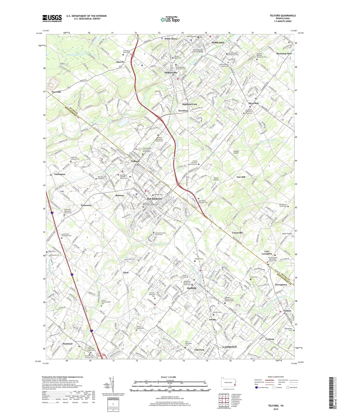
2023 topographic map quadrangle Telford in the state of Pennsylvania. Scale: 1:24000. Based on the newly updated USGS 7.5' US Topo map series, this map is in the following counties: Bucks, Montgomery. The map contains contour data, water features, and other items you are used to seeing on USGS maps, but also has updated roads and other features. This is the next generation of topographic maps. Printed on high-quality waterproof paper with UV fade-resistant inks.
Quads adjacent to this one:
West: Perkiomenville
Northwest: Milford Square
North: Quakertown
Northeast: Bedminster
East: Doylestown
Southeast: Ambler
South: Lansdale
Southwest: Collegeville
This map covers the same area as the classic USGS quad with code o40075c3.
Contains the following named places: Abington - Lansdale Hospital, Almont, Almont Post Office, Ann Reno Mobile Home Park, Apple Tree Estates, Banbury, Banbury Crossing, Belcourt Manor, Bergey Dam, Blooming Glen Mennonite Meetinghouse Graveyard - South, Boland Airport, Borough of Hatfield, Borough of Perkasie, Borough of Sellersville, Borough of Silverdale, Borough of Souderton, Borough of Telford, Bramble Gate, Bremen Woods, Bridgetown, Bridle Path Elementary School, Bridle Run, Calvary Church of Souderton Cemetery, Cambridge Reserve, Centennial Ridge, Christ Lutheran Church Cemetery, Christ Reformed Church of Indian Creek Cemetery, Clemens Memorial Park, Cobblestone East, Colmar, Colmar Fire Company Station 12, Colmar Post Office, Colmar Station, County Line Plaza Shopping Center, County Line Shopping Center, Cowpath Village, Cross Gate, Derstine Estates, Derstines, Dock Manor Terrace, Dock School, E M Crouthamel Elementary School, Earl B Druckenmiller Park, Earlington, Earlington Post Office, Elroy, Enos Godshall Park, Estates at Tall Oaks, Fair Hill, Fehl Dam, Forrest View, Fortuna, Fortuna Station, Franconia, Franconia Community Park, Franconia Hunt, Franconia Mennonite Church Cemetery, Franconia School, Franconia Township Hall, Fricks Cemetery, Gehris Airport, Gerhart Dam, Gold Mine Field, Grand View Hospital, Green Meadows, Gristmill Run, Gunden Airport, Hallman Dam, Harley Cemetery, Hatfield, Hatfield Borough Hall, Hatfield Cemetery, Hatfield Church of the Brethren Cemetery, Hatfield Community Park, Hatfield Post Office, Hatfield Township Hall, Hatfield Township Police Station, Hatfield Volunteer Fire Company Station 17, Hatfield Volunteer Fire Company Substation 17B, Hidden Springs Mobile Home Park, Highland Park, Hill Crest Estate, Hillcrest Estate, Hillside Cemetery, Hilltown Crossings Shopping Center, Hilltown Dam, Hilltown Industrial Park, Hilltown Plaza Shopping Center, Hilltown School, Hilltown Shopping Center, Hilpert, Holiday House Recreation Area, Hunter Crest, Hunters Greene, I G Rosenberger Inc Airport, Immanuel Leidy's Church Cemetery, Indian Creek Mennonite Cemetery, Indian Creek Mennonite School, Indian Crest Junior High School, Indian Valley Golf Course, James Memorial Park, Jerusalem Union Cemetery, John M Grasse Elementary School, John S Clemens Memorial Park, Kimberwick Green, Kulp Elementary School, Kulp Park, Landis Dam, Lansdale Industrial Park, Laudenslager School, Lenape Lake, Lenare Park, Lexington Farms, Lexington Leas, Line Lexington, Line Lexington Industrial Park, Line Lexington Mennonite Church Cemetery, Line Lexington Post Office, Lions Gate II, Little Zion Lutheran Cemetery, Living Faith Fellowship Cemetery, Lutheran Home for the Aged, Mainland, Mainland Golf Course, Mainland Post Office, Menlo Park, Mennonite Brethren in Christ Cemetery, Mews at Wickford Commons, Midway Business Center, Mill Creek, Montgomery Cemetery, Moyer Dam, Naceville, Navarro Field, Oak Grove Trailer Park, Oak Park Elementary School, Oak Wood East, Orchard Glen, Orchard Station, Orvilla, Orvilla Cemetery, Pear Tree Village, Pelham Green, Penn View Christian School, Pennfield Manor, Pennfield Middle School, Pennridge Junior High School, Perkasie, Perkasie Mennonite Cemetery, Perkasie Square Shopping Center, Plains Mennonite Cemetery, Pleasant Spring Creek, Quiet Acres Mobile Home Park, Ralphs Corner, Ralphs Corner Shopping Center, Reliance, Rockhill Industrial Park, Rockhill Mennonite Church Cemetery, Saint Agnes - Sacred Heart School, Saint Agnes Cemetery, Saint Andrews Union Cemetery, Saint Marie Goretti School, Saint Paul's Lutheran Church Cemetery, Saint Peters Union Cemetery - East, Saint Philip Orthodox Cemetery, Salford Schwenkfelder Cemetery, Schlichter, Sellersville, Sellersville Cemetery, Sellersville Elementary School, Sellersville Heights, Sellersville Post Office, Selsie Village, Silverdale, Silverdale Brethren in Christ Cemetery, Silverdale Post Office, Snyder Square, Snyder Square Shopping Center, Society Meadows, Souderton, Souderton Airport, Souderton Area Senior High School, Souderton Borough Park, Souderton Community Park, Souderton CS Collaborative School, Souderton Mennonite Cemetery, Souderton Post Office, Souderton Shopping Center, Souderton Square, Souderton Square Shopping Center, South Perkasie Covered Bridge, South Perkasie Evangelical Cemetery, State Game Lands Number 196, Stonycrest, Stout Graveyard, Summerwind, Telford, Telford Business Park, Telford Chase, Telford Commons, Telford Elementary School, Telford Hills, Telford Industrial Park, Telford Park, Telford Post Office, Tennis - Lukens Cemetery, Township of Franconia, Township of Hatfield, Township of Hilltown, Township of West Rockhill, Trewigtown, Trinity Cemetery, Turnpike Industrial Center, Twin Lakes Country Club, Twin Peak Industrial Center, Twin Woods Golf Course, Unionville, United Church of Christ Cemetery, Upper Bucks Christian School, Village at Salford Mill, Village Scene Trailer Park, Walton Farm Elementary School, WBMR-FM (Telford), West Rockhill Elementary School, White Horse, Wynmere Hunt, Yorkshire Commons, Zion Memorial Gardens, ZIP Codes: 18915, 18932, 18960, 18962, 18964, 18969, 19440