MyTopo
Perkiomenville Pennsylvania US Topo Map
Couldn't load pickup availability
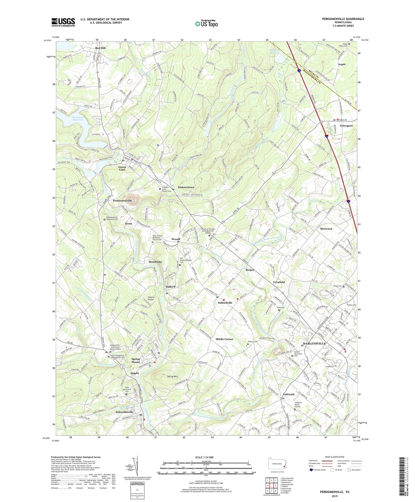
2023 topographic map quadrangle Perkiomenville in the state of Pennsylvania. Scale: 1:24000. Based on the newly updated USGS 7.5' US Topo map series, this map is in the following counties: Montgomery, Bucks. The map contains contour data, water features, and other items you are used to seeing on USGS maps, but also has updated roads and other features. This is the next generation of topographic maps. Printed on high-quality waterproof paper with UV fade-resistant inks.
Quads adjacent to this one:
West: Sassamansville
Northwest: East Greenville
North: Milford Square
Northeast: Quakertown
East: Telford
Southeast: Lansdale
South: Collegeville
Southwest: Phoenixville
This map covers the same area as the classic USGS quad with code o40075c4.
Contains the following named places: Alvin C Alderfer Recreation Area, Argus, Argus Post Office, Artcraft Recreation Association Dam, Bellingham Knoll, Bere Hall, Bergey, Bergey's Mill Park, Borough of Green Lane, Borough of Schwenksville, Boulder Valley Sportsman Club, Branchwood Park, Brey Dam, Bullfrog Creek, Camp Delmont Dam, Camp Kweebec Dam, Camp Skippy, Camp Wawa Park, Cheswyck, Christ Evangelical Congregation Cemetery, Church of the Holy Spirit Memorial Garden, Club Dam, Creek Dam, Daniel W Roth Memorial Park, Deep Creek, Deep Creek Dam, Delmont Boy Scout Camp, Delphi, Delps Cemetery, Delps Meetinghouse Church, Eastern Bible Institute, Eden Mennonite Cemetery, Eden Mennonite Church, Fish Game and Forestry Association, Friedens Union Church, Friedens Union Church Cemetery, Godshalls Airport, Goshenhoppen Creek, Governor Pennypacker Monument, Green Hill Mobile Home Park, Green Lane, Green Lane Borough Hall, Green Lane Fire Company - Station 42, Green Lane Post Office, Green Lane Reservoir Dam, Green Lane-Marlborough School, Groff Dam, Groffs Mill Park, Haman Cemetery, Harley Commons Shopping Center, Harley Glen, Harleysville, Harleysville Area EMS - Harleysville Station, Harleysville Census Designated Place, Harleysville Community Center Park, Harleysville Community Fire Company - Station 89, Harleysville Homestead, Harleysville Post Office, Hart Lake Dam, Hart Scout Camp, Heckler Plains Park, Hendricks, Hickory Tree Estates, Indian Creek, Indian Creek Brethren Cemetery, Indian Creek Church, Indian Crest Farms, Indian Valley Junior High School, Indian Valley Mennonite Church, Keller Dam, Kings Airport, Kingscote, Knight Dam, Knight Lake, Kratz, Kratz Dam, Lake Aree Dam, Lake Delmont, Lederach, Lederach Burial Ground, Lederach Post Office, Leidy Dam, Lower Frederick Fire Company - Station 52, Lower Frederick Township Building, Lower Frederick Township Police Department, Lower Frederick Township Police Station, Lower Salford Elementary School, Lower Salford Township Hall, Lower Salford Township Police Department, Lower Salford Township Police Station, Macoby Creek, Maple Run Reservoir, Marlborough Township Hall, Marlborough Township Police Department, Marlborough Township Police Station, Marlboroville, McLeans Station, Mine Run, Morwood, New Boys Life Ranch School, New Life Boys Ranch, New Life School, Old Goschenhoppen Cemetery, Old Goshenhoppen Church, Penn Oak Manor, Pennypacker Mills County Park, Perkiomen Valley Elementary North School, Perkiomenville, Perkiomenville Mennonite Cemetery, Perkiomenville Mennonite Church, Perkiomenville Post Office, Plymouth Community Ambulance Medic 308, Price Cemetery, Quaker Pike Heliport, Red Hill, Ridge Valley, Ridge Valley Cemetery, Ridge Valley Creek, Ridge Valley Dam, Rolling Turf Golf Course, Rosecliff, Saint Johns Church, Saint Marys Church, Salford, Salford Church, Salford Dam, Salford Mennonite Cemetery, Salford Pond, Salford Post Office, Salford Ridge, Salford Square Shopping Center, Salford Township Hall, Salford-Upper Salford Township School, Salfordville, Salfordville Post Office, Schwenksville, Schwenksville Borough Hall, Schwenksville Community Library, Schwenksville Elementary School, Schwenksville Fire Company - Station 73, Schwenksville Police Station, Schwenksville Post Office, Scioto Creek, Shirks Corner, Shontz Airport, Shops at Harleysville, Silverbrook Farms, Spring Mount, Spring Mount Census Designated Place, Spring Mount Post Office, Spring Mount Ski Area, Spring Mount Summit, Spring Mountain, Stormfield, Sumneytown, Sumneytown Post Office, Swamp Creek, Tabor Church, Tabor United Methodist Church Cemetery, Telford Diving and Rescue Station 64, Telford Volunteer Diving and Rescue Unit Station 64, The Heathers, Township of Lower Frederick, Township of Lower Salford, Township of Marlborough, Township of Salford, Township of Upper Salford, Tylersport, Tylersport Chapel, Tylersport Post Office, Tylersport Volunteer Fire Company Station 72, Unami Creek, Underkoffler - Schlotterer Burial Ground, Union Chapel, Upper Knickerbocker Dam, Upper Perkiomen Valley County Park, Upper Salford Park, Upper Salford Township Hall, Upper Salford Volunteer Fire Company - Station 78, Vaughn Run, Vernfield, Vernfield Elementary School, Village Brook Estate, William Rahmer Memorial Park, Woxall, Woxall Census Designated Place, Woxall Post Office, Yarrow Airport, Zieglersville, Zieglerville Post Office, ZIP Codes: 18054, 18076, 19438, 19473, 19492