MyTopo
Murrysville Pennsylvania US Topo Map
Couldn't load pickup availability
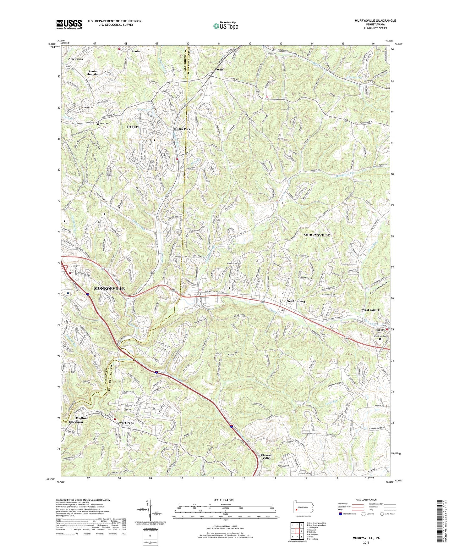
2019 topographic map quadrangle Murrysville in the state of Pennsylvania. Scale: 1:24000. Based on the newly updated USGS 7.5' US Topo map series, this map is in the following counties: Westmoreland, Allegheny. The map contains contour data, water features, and other items you are used to seeing on USGS maps, but also has updated roads and other features. This is the next generation of topographic maps. Printed on high-quality waterproof paper with UV fade-resistant inks.
Quads adjacent to this one:
West: Braddock
Northwest: New Kensington West
North: New Kensington East
Northeast: Vandergrift
East: Slickville
Southeast: Greensburg
South: Irwin
Southwest: McKeesport
Contains the following named places: A E Oblock Junior High School Library, Abers Creek, Blackburn, Boyce Park Ski Area, Bulltown Schoolhouse, Byers Run, Christ Lutheran Church, Clay Banks, Collins Lake, Crossroads Vineyard Christian Fellowship Church, Denmark Manor Church, Dice Pumping Station, Eastern Area Special School, Emanuel Church, Export, Export Post Office, Export Volunteer Fire Department, Exton Lake, Forbes Day Care Center, Forbes Regional Hospital, Franklin, Franklin Regional Senior High School, Grace Baptist Church, Grace Reformed Presbyterian Church, Grandview Cemetery, Greater Works Christian School, Haymakers Run, Hill Pumping Station, Holiday Farms Country Day School, Holiday Park, Holiday Park Baptist Church, Holiday Park United Methodist Church, Holiday Park Volunteer Fire Department Station 236, Humms Run, Kemerer Hollow, Kinder Care Learning Center, Kingdom Hall of Jehovahs Witnesses, Laird Cemetery, Level Green, Level Green Census Designated Place, Level Green School, Level Green Volunteer Fire Department, Lyons Run, Manor Valley Golf Course, Manordale, Meadowink Golf Course, Monroeville Fire Department Emergency Medical Services, Monroeville Hills Shopping Center, Monroeville Volunteer Fire Company 4 Station 194 - Emergency Medical Services Station 355, Mother of Sorrows Church, Mother of Sorrows School, Municipality of Murrysville, Murrysville, Murrysville Alliance Church, Murrysville Community Library, Murrysville Golf Course, Murrysville Medic One, Murrysville Methodist Preschool, Murrysville Police Department, Murrysville Post Office, Murrysville Presbyterian Preschool, Murrysville Volunteer Fire Company, Newlonsburg, Newlonsburg Presbyterian Church, Olive Church of Murrysville, Our Lady of Joy Church, Piersons Run, Pittsburgh East Community Church, Pleasant Valley, Plum Creek Cemetery, Plum Creek Church, Plum Creek Mine, Pond Three, Rainbow Connection Education Center, Renton Elementary School, Renton Junction, Renton Slurry Pond Three Dam, Renton Volunteer Fire Department Station 234, Repeater Station, Saint Januarius Mission, Saint Michael Archangel Serbian Orthodox Church, Sardis, Sardis Church, Sardis Volunteer Fire Company, Saunders Station, Simpson Run, Sloan Pumping Station, Sri Shirdi Sai Baba Temple, Steels Run, Tetelestai Church, Thompson Run, Tomer's Greenhouse, Tonkin Pumping Station, United Methodist Preschool, West Export, Westmoreland Country Club, Westmoreland County Federated Library System, WPTT-TV (Pittsburgh), Wyatt Airport, ZIP Codes: 15085, 15239, 15668