MyTopo
New Kensington East Pennsylvania US Topo Map
Couldn't load pickup availability
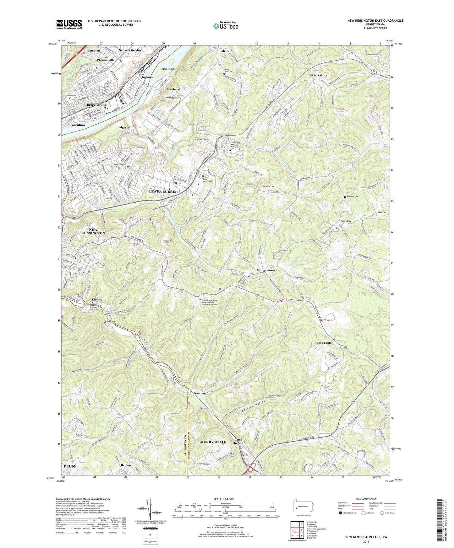
2023 topographic map quadrangle New Kensington East in the state of Pennsylvania. Scale: 1:24000. Based on the newly updated USGS 7.5' US Topo map series, this map is in the following counties: Westmoreland, Allegheny. The map contains contour data, water features, and other items you are used to seeing on USGS maps, but also has updated roads and other features. This is the next generation of topographic maps. Printed on high-quality waterproof paper with UV fade-resistant inks.
Quads adjacent to this one:
West: New Kensington West
Northwest: Curtisville
North: Freeport
Northeast: Leechburg
East: Vandergrift
Southeast: Slickville
South: Murrysville
Southwest: Braddock
This map covers the same area as the classic USGS quad with code o40079e6.
Contains the following named places: Alcoa Center, Alcoa Technical Center Emergency Response Team and Fire Department, Allegheny Ludlum Emergency Medical Services, Allegheny River Lock and Dam Four, Allegheny River Pool Four, Allegheny Valley Church of Christ, Allegheny Valley Hospital, Bethel Cemetery, Bethel Nursery School, Bethel Run, Bethel United Methodist Church, Bethesda Cemetery, Bethesda Church, Bethesda Evangelical Lutheran Church, Blessed Sacrament School, Bon Air School, Borough of Brackenridge, Borough of Plum, Brackenridge, Brackenridge Avenue School, Brackenridge Borough Hall, Brackenridge Police Department, Brackenridge Post Office, Braeburn, Braeburn School, Braeview Volunteer Fire Station, Burrell High School, Burrell Park, Calvary Baptist Church, Calvary Church, Camp Jo-Ann, Chartiers Run, Christ Church, Christian Alliance Church, Church of God, City of Lower Burrell, Compton, Dayspring Christian Center, Drennen, Dugan Cemetery, Edgecliff, Fairmount Elementary School, Faith Evangelical Lutheran Church, First Baptist Church, Gladeview School, Grace Community Presbyterian Church, Greenwood Memorial Park Cemetery, Hankeys Cemetery, Harrison Township Police Department, Heights Plaza Shopping Center, Highlands Junior High School, Highlands Senior High School Library, Hillcrest Alliance Church, Hillcrest Shopping Center, Hilltop Hose Company Station 168, Holtzhauer Lake, Hustin School, Jacks Island, Jesus Apostolic Church, Kingdom Hall Church, Kinlock, Logans Ferry Heights Volunteer Fire Department Station 235, Lower Burrell Baptist Church, Lower Burrell City Hall, Lower Burrell Fire Company 3, Lower Burrell Police Department, Lower Burrell Post Office, Lower Burrell Volunteer Fire Company 1, Markle, Markle Volunteer Fire Department, Martin Elementary School, Melwood Park, Merwin Compressor Station, Metcalf, Milligantown, Mount Hope Cemetery, Natrona, Natrona Heights, Natrona Heights Post Office, Natrona Heights Presbyterian Church, New Kensington Commercial School, New Kensington Fire Company 4, Oak Hill Golf Course, Our Lady of the Most Blessed Sacrament Church, Parkway Ambulance Service, Penn State University-New Kensington Campus, Pine Run Church, Pine Run Presbyterian Church Cemetery, Pioneer Hose Company - Station 112, Pleasantville, Plum, Plum Emergency Medical Services Station 485, Polish Roman Catholic Union Branch Number 224, Pond Four, Pond Street School, Prospect Cemetery, Prospect School, Puckety Church, Rabbit Foot Lake, Renton, Renton Refuse Bank Pond Four Dam, Riverview School, Rolling Fields Golf Course, Saint Barnabas Church, Saint Joseph Church, Saint Joseph High School, Saint Ladislaus Church, Saint Margaret Marys Church, Saint Marys Cemetery, Shearersburg, Shiloh Baptist Church, Shiloh Church, Stewart Elementary School, Stewart School, Township of Allegheny, Township of Upper Burrell, Upper Burrell Township Fire Company, Upper Burrell Township Police Department, Upper Burrell Township School, Weinel School, Whitten Hollow, ZIP Codes: 15014, 15068