MyTopo
New Holland Pennsylvania US Topo Map
Couldn't load pickup availability
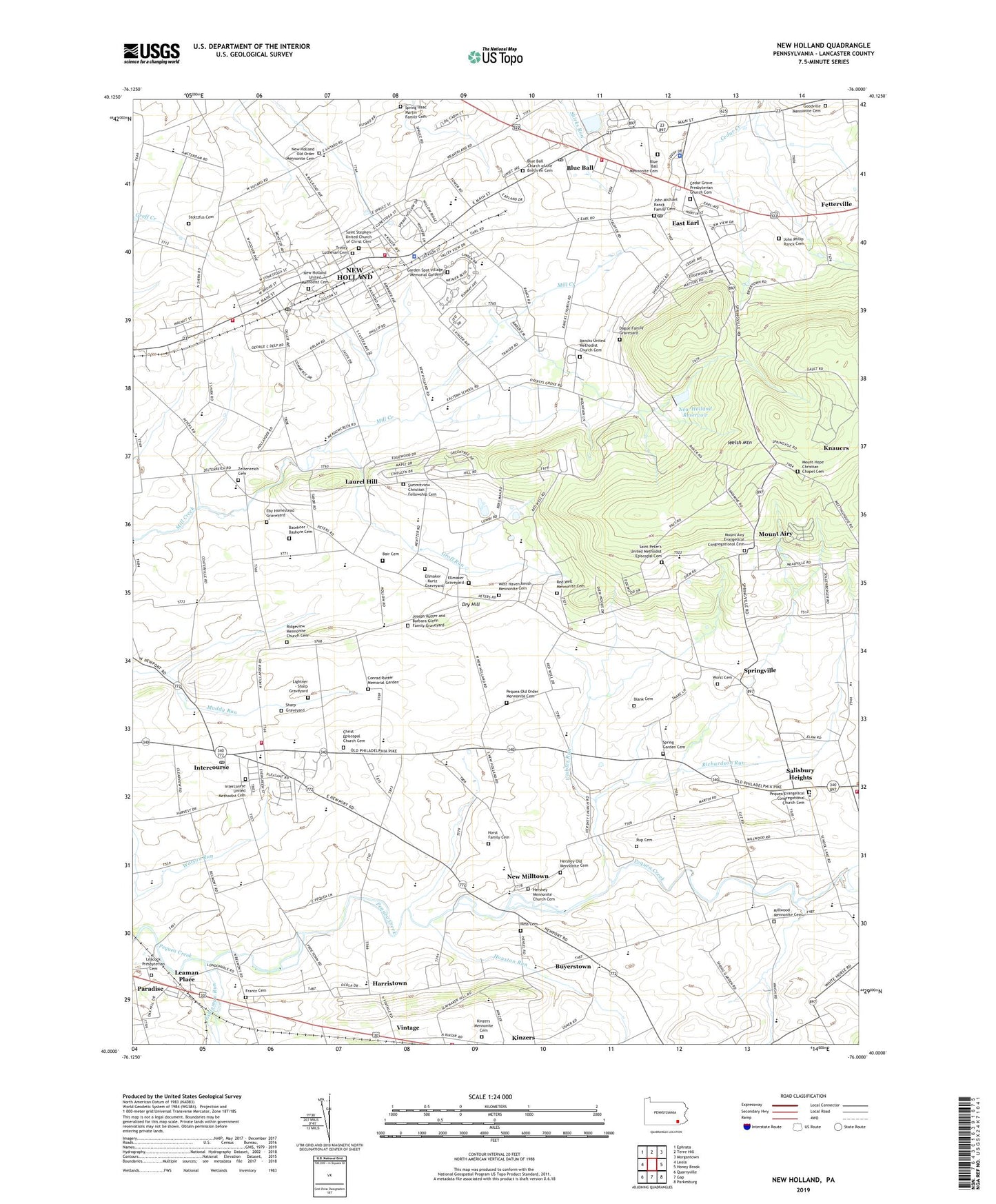
2019 topographic map quadrangle New Holland in the state of Pennsylvania. Scale: 1:24000. Based on the newly updated USGS 7.5' US Topo map series, this map is in the following counties: Lancaster. The map contains contour data, water features, and other items you are used to seeing on USGS maps, but also has updated roads and other features. This is the next generation of topographic maps. Printed on high-quality waterproof paper with UV fade-resistant inks.
Quads adjacent to this one:
West: Leola
Northwest: Ephrata
North: Terre Hill
Northeast: Morgantown
East: Honey Brook
Southeast: Parkesburg
South: Gap
Southwest: Quarryville
Contains the following named places: Amsterdam School, Bair Cemetery, Basehoar / Bashore Cemetery, Beacon Hollow Farm, Beiler Farm, Blank Cemetery, Blue Ball, Blue Ball Census Designated Place, Blue Ball Church of the Brethren Cemetery, Blue Ball Mennonite Cemetery, Blue Ball Post Office, Borough of New Holland, Buyerstown, Cedar Fox Farms, Cedar Grove Presbyterian Church Cemetery, Cedar Grove School, Cedar Lane, Center School, Centerville School, Christ Episcopal Church Cemetery, Conrad Rutter Memorial Garden, Dague Family Graveyard, Double L Farm, Dry Hill, East Earl, East Earl Census Designated Place, East Earl Post Office, East Earl Township Police Department, Eby Homestead Graveyard, Ellmaker - Kurtz Graveyard, Ellmaker Graveyard, Eshleman Run, Fetterville, Frantz Cemetery, Garden Spot Fire Rescue Station 39 - 1, Garden Spot Fire Rescue Station 39 - 2, Garden Spot Fire Rescue Station 39 - 3, Garden Spot Junior Senior High School, Garden Spot Village Memorial Gardens, Ginger Tree Farms, Goodville Mennonite Cemetery, Green Bank, Green Bank Post Office, Greenbank School, Groff Run, Harristown, Hatville, Hatville School, Hershey Church, Hershey Mennonite Church Cemetery, Hershey Old Mennonite Cemetery, Herstein Farm, Hess Cemetery, Hickory Grove School, Hollow School, Horst Family Cemetery, Houston Run, Intercourse, Intercourse Census Designated Place, Intercourse Fire Company Station 44, Intercourse Post Office, Intercourse United Methodist Cemetery, John Michael Ranck Family Cemetery, John Philip Ranck Cemetery, Joseph Rutter and Barbara Glenn Family Graveyard, King Farm, King Ridge Farm, Kinzers Mennonite Cemetery, Lapp Dairy Farm, Lapp Valley Farms, Laurel Hill, Leacock Elementary School, Leacock Presbyterian Cemetery, Leaman Place, Leid's Greenhouse, Lightner - Sharp Graveyard, Maple Grove School, Millwood Church, Millwood Mennonite Cemetery, Millwood School, Mount Airy, Mount Airy Evangelical Congregational Cemetery, Mount Hope Christian Chapel Cemetery, Mount Hope Church, Mount Tabor Church, Mussers School, New Holland, New Holland Ambulance Association Station 37, New Holland Heliport, New Holland Old Order Mennonite Cemetery, New Holland Police Department, New Holland Post Office, New Holland Reservoir, New Holland Reservoir Dam, New Holland United Methodist Cemetery, New Milltown, New Milltown Post Office, Oberholtzer Dairy Farm, Our Lady of Lourdes Church, Paradise Census Designated Place, Paradise Elementary School, Pequea Church, Pequea Evangelical Congregational Church Cemetery, Pequea Old Order Mennonite Cemetery, Pequea Valley High School, Pondlea Farm, Rancks Church, Rancks United Methodist Church Cemetery, Red Well Mennonite Cemetery, Richardson Run, Ridgeview Mennonite Church Cemetery, Rup Cemetery, Saint Peter's United Methodist - Episcopal Cemetery, Saint Stephen United Church of Christ Cemetery, Salisbury Elementary School, Salisbury Heights, Salisbury Post Office, Sharp Graveyard, South Slope Farm, Spring Garden, Spring Garden Cemetery, Spring Isaac Martin Family Cemetery, Spring Trout Fish Farm, Springville, Stoltzfus Cemetery, Stoltzfus Dairy Farm, Summitview Christian Fellowship Cemetery, Summitville School, Three Streams Farm and Nursery, Town's Edge Greenhouse, Township of Earl, Township of East Earl, Township of Leacock, Trinity Lutheran Cemetery, Umbles Run, Vinola, Vintage, Vintage Station, Weiler Farm, West Haven Amish Mennonite Cemetery, Western School, Westfield Egg Farm, White Horse Fire Company and Emergency Medical Services Station 49, White Horse Run, White Horse School, Williamstown, Worst Cemetery, Zeiset Farms, Zeltenreich Cemetery, Zeltenriech Church, ZIP Codes: 17529, 17557