MyTopo
Quarryville Pennsylvania US Topo Map
Couldn't load pickup availability
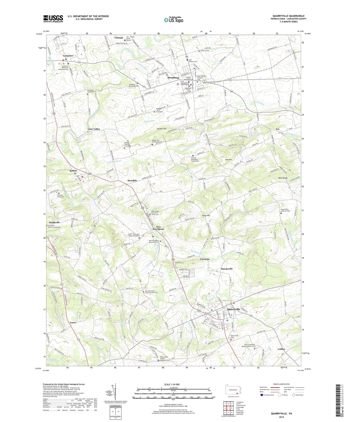
2023 topographic map quadrangle Quarryville in the state of Pennsylvania. Scale: 1:24000. Based on the newly updated USGS 7.5' US Topo map series, this map is in the following counties: Lancaster. The map contains contour data, water features, and other items you are used to seeing on USGS maps, but also has updated roads and other features. This is the next generation of topographic maps. Printed on high-quality waterproof paper with UV fade-resistant inks.
Quads adjacent to this one:
West: Conestoga
Northwest: Lancaster
North: Leola
Northeast: New Holland
East: Gap
Southeast: Kirkwood
South: Wakefield
Southwest: Holtwood
This map covers the same area as the classic USGS quad with code o39076h2.
Contains the following named places: Ashland School, Borough of Quarryville, Borough of Strasburg, Bowman Graveyard, Brackbill - Neff Graveyard, Bunker Hill, Bunker Hill Amish Cemetery, Calamus Run, Camargo, Camargo Post Office, Collins, Crikadoo Farm, D and J Farm, Edgefield Farms, Faith Reform Presbyterian Church, First Presbyterian Church Cemetery, George A Smith Middle School, German Reformed Church Cemetery, Goff Run, Good Harvest Farm, Green Hills Farm, Groff - Stoneroad - Reese Graveyard, Groff Valley Farms, Groffdale Farm, Hans Herr Elementary School, Harmony School, Hawksville, Herr - Moyer Burial Ground, Hessdale, Hessdale Post Office, Hope Valley Farms, Iva, John Howery Cemetery, Kendig Run, Lampeter, Lampeter Census Designated Place, Lampeter Community Park, Lampeter Fire Company 1 Station 54, Lampeter Post Office, Lampeter Reformed Mennonite Cemetery, Lampeter-Strasburg High School, Lancaster Emergency Medical Services Quarryville Station 56 - 5, Lancaster Emergency Medical Services Strasburg Station 56 - 6, LeFevre Cemetery, Lime Valley, Little Beaver Creek, Martin Family Graveyard, Martin Farm, Martin Melvin Junior High School, Martinsville Post Office, Mellinger Farms, Memorial Park, Misty Hollow Farm, Mount Eden Church, Mount Eden Lutheran Cemetery, Mount Hope Church, Mount Hope United Methodist Cemetery, New Providence, New Providence Church, New Providence Church of God Cemetery, New Providence Mennonite Cemetery, New Providence Post Office, North Star School, Oak Hill, Oak Hill School, Oakbottom, Pequea School, Pondbank Farms, Providence Elementary School, Quarryville, Quarryville Cemetery, Quarryville Elementary School, Quarryville Fire Company 1 Station 57, Quarryville Police Department, Quarryville Post Office, Quarryville Presbyterian Home, Refton, Refton Census Designated Place, Refton Fire Company Station 59, Refton Post Office, Romella Farms, Ross Hill School, Rush Dairy, Saint Catherine of Siena Church, Saint Catherines Roman Catholic Cemetery, Saint Michael's Lutheran Cemetery, Saint Paul Lutheran Church, Sandstone School, Smithville Church of God Cemetery, South Fork Big Beaver Creek, Springville School, Steep Side Farms, Stony Hill, Strasburg, Strasburg Borough Police Department, Strasburg Cemetery, Strasburg Elementary School, Strasburg Fire Company 1 Station 5, Strasburg Jaycee Park, Strasburg Mennonite Cemetery, Strasburg Post Office, Strasburg Reservoir, Swamp Meadow Farm, Township of Eden, Township of Providence, Township of Strasburg, Truce, Tschantz Graveyard, United Methodist Church, Walnut Run, Walnut Run School, WDAC-FM (Lancaster), Wesley Methodist Cemetery, West Lampeter Township Police Department, Wheatland Mills Post Office, Zion Church, Zion United Church of Christ Cemetery, ZIP Codes: 17560, 17579