MyTopo
Steelton Pennsylvania US Topo Map
Couldn't load pickup availability
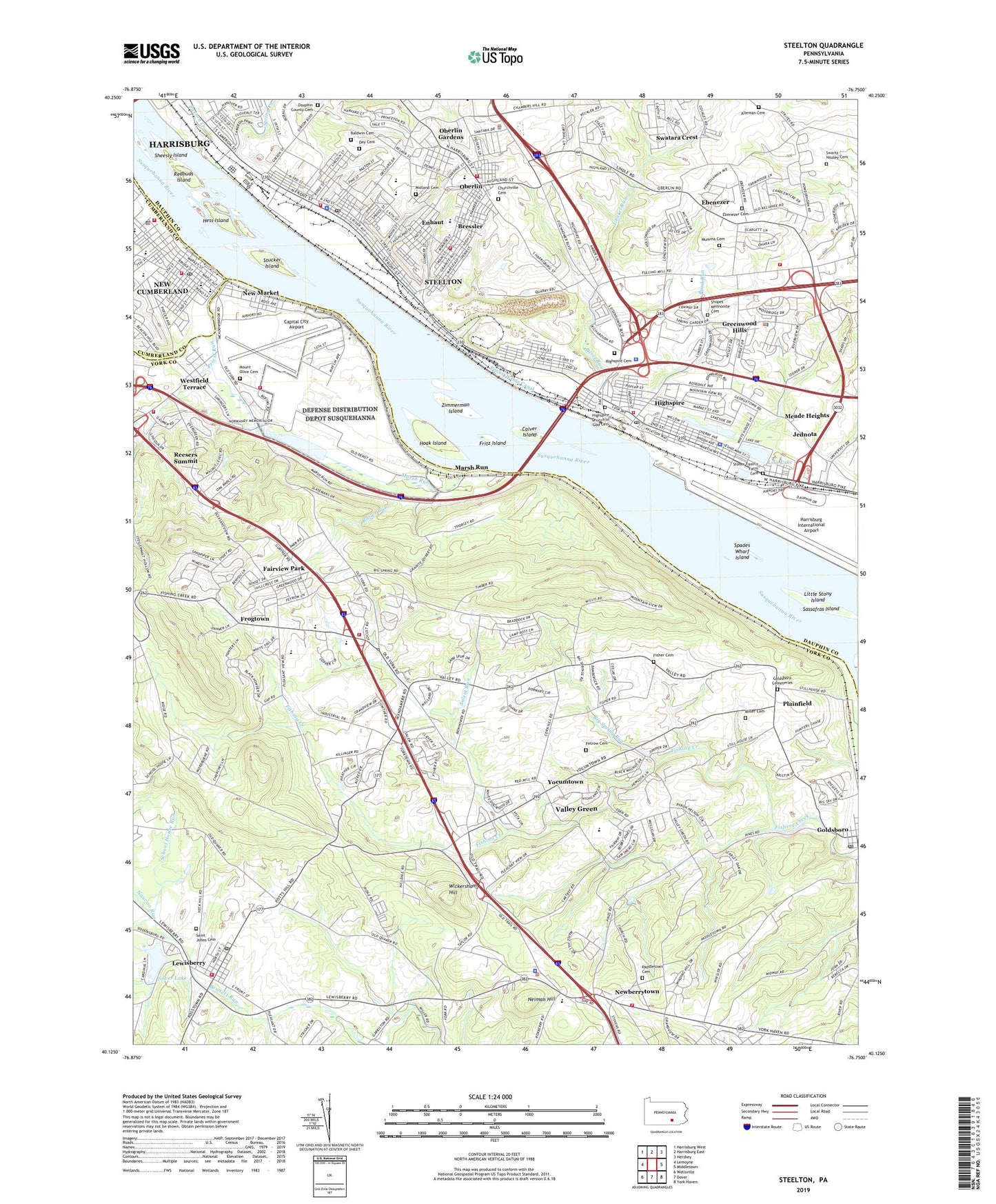
2019 topographic map quadrangle Steelton in the state of Pennsylvania. Scale: 1:24000. Based on the newly updated USGS 7.5' US Topo map series, this map is in the following counties: York, Dauphin, Cumberland. The map contains contour data, water features, and other items you are used to seeing on USGS maps, but also has updated roads and other features. This is the next generation of topographic maps. Printed on high-quality waterproof paper with UV fade-resistant inks.
Quads adjacent to this one:
West: Lemoyne
Northwest: Harrisburg West
North: Harrisburg East
Northeast: Hershey
East: Middletown
Southeast: York Haven
South: Dover
Southwest: Wellsville
Contains the following named places: Alleman Cemetery, Baldwin Cemetery, Bass Lake, Baughman Church, Beulah Church, Big Spring Run, Borough of Goldsboro, Borough of Highspire, Borough of Lewisberry, Borough of Steelton, Bressler, Bressler Census Designated Place, Bressler-Enhaut-Oberlin Census Designated Place, Burd Run, Buser Run, Calver Island, Capital City Airport, Cedar Grove School, Cherry Hill, Churchville Cemetery, Citizens Fire Company of Highspire Station 55, Colonial Woods, Colonial Woods South, Community Life Team Emergency Medical Ambulance Station 1 Services, Crossroads School, Dauphin County Cemetery, Day Cemetery, Defense Distribution Center New Cumberland, East End School, East Side School, Ebenezer, Ebenezer Cemetery, Enhaut, Enhaut Census Designated Place, Etters Post Office, Fairview Church, Fairview Industrial Park, Fairview Park, Fairview Township Fire Department Station 1, Fairview Township Fire Department Station 68 - 2, Fairview Township Fire Department Station 68 - 3, Federal Fire Department New Cumberland, Fetrow Cemetery, Fifth Street School, Fisher Cemetery, Fishing Creek Salem United Methodist Church, Fishing Creek School, Friendship Fire Company of Bressler Station 41, Fritz Island, Frogtown, Goldsboro, Grace Church, Green Valley Golf Course, Greenwood Hills, Harmony Hall, Harrisburg International Airport, Harvest Hills, Hess Island, Highspire, Highspire Cemetery, Highspire Church of God Cemetery, Highspire Police Department, Highspire Post Office, Hillside School, Hoak Island, Jednota, John C Kunkel Elementary School, Laurel Run, Laurel Wood Mobile Home Park, Lewisberry, Lewisberry Post Office, Lisa Lake, Little Hollywood Mobile Home Park, Little Stony Island, Locust Manor Mobile Home Park, Lower Swatara Township Police Department, Lower Swatara Volunteer Fire Department Station 59, Marsh Run, Marsh Run Pond Dam, Meade Heights, Midland Cemetery, Miller Cemetery, Mount Olive Cemetery, Mount Zion Church, Mumma Cemetery, Nauvoo Run, Neidig Church, Neiman Hill, New Cumberland Army Air Field, New Cumberland Fire Department Company 10, New Cumberland First Church of God, New Cumberland Police Department, New Cumberland Post Office, New Market, New Market Census Designated Place, Newberry School, Newberry Township Fire Department Station 31, Newberry Township Police Department, Newberrytown, Oberlin, Oberlin Census Designated Place, Oberlin Gardens, Olmstead Plaza, Paddletown Cemetery, Park Away Mobile Home Park, Paxton Creek, Pennsylvania Canal, Pennsylvania State Police Troop T Headquarters and Highspire Station, Plainfield, Priest Run, Quaker Village, Ramblewood, Ratler Run, Redbuds Island, Redland Friends Meetinghouse, Redland High School, Redland Village, Reesers Summit, Remeos Mobile Home Park, Reno School, Saint Ann School, Saint James Church, Saint Johns Cemetery, Saint Johns School, Saint Marys Church, Saint Pauls Church, Saint Peters Church, Saint Theresa School, Salem Church, Salem Run, Sassafras Island, Sawmill Run, School House Run, Seventh Street School, Sheesly Island, Shopes Mennonite Cemetery, Silver Lake, Silver Lake Dam, Skyview Mobile Home Park, Slaseman Mobile Home Park, Smoketown Cemetery, Spades Wharf Island, Spring Creek, Springville, State Game Lands Number 275, Steelton, Steelton Highspire School, Steelton Police Department, Steelton Post Office, Steelton Quarry, Steelton Volunteer Fire Department Station 50, Stillhouse Run, Stoner Family Farm Cemetery, Stucker Island, Swartz Nissley Cemetery, Swatara Crest, Swatara Emergency Medical Services, Swatara High School, Swatara Township Police Department, Swatara Township Volunteer Fire Company Station 49, The Red Land Community Library, Township of Fairview, Township of Lower Swatara, Township of Newberry, Township of Swatara, Trinity Church, Turnpike Number One Heliport, Valley Church, Valley Green, Valley Green Census Designated Place, Valley Green Estates, Valley Green Mall, West Shore YMCA Camp, West Side School, Westfield Terrace, WFEC-AM (Harrisburg), Wickersham Hill, Willow Farms Mobile Home Park, WKCD-FM (Mechanicsburg), Yellow Breeches Creek, Yocumtown, Zimmerman Island, Zion Church, ZIP Codes: 17034, 17070, 17113, 17319