MyTopo
East Greenwich Rhode Island US Topo Map
Couldn't load pickup availability
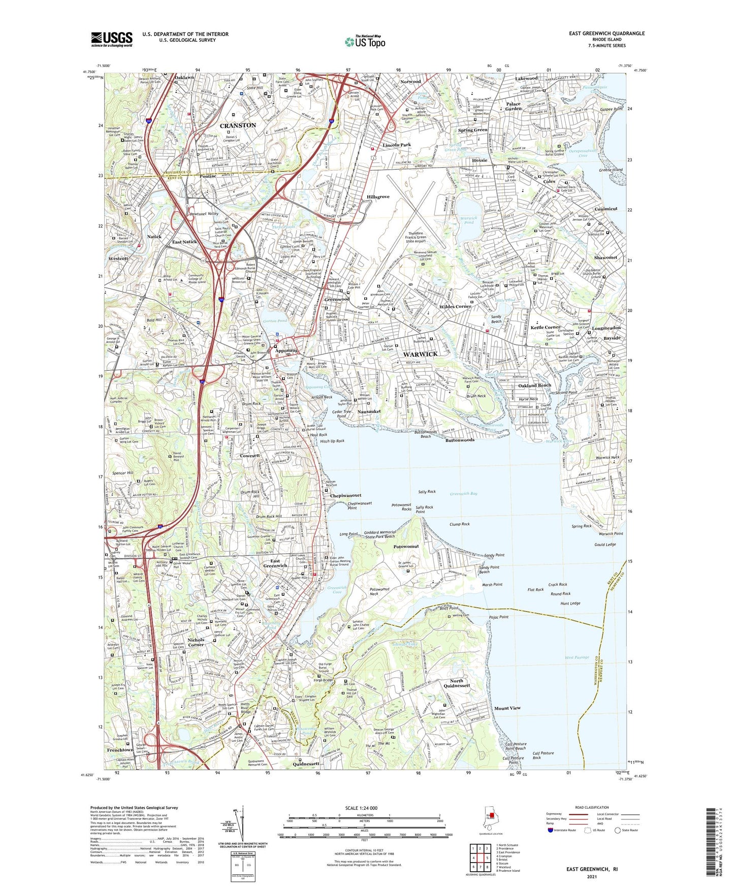
2021 topographic map quadrangle East Greenwich in the state of Rhode Island. Scale: 1:24000. Based on the newly updated USGS 7.5' US Topo map series, this map is in the following counties: Kent, Washington, Providence, Newport. The map contains contour data, water features, and other items you are used to seeing on USGS maps, but also has updated roads and other features. This is the next generation of topographic maps. Printed on high-quality waterproof paper with UV fade-resistant inks.
Quads adjacent to this one:
West: Crompton
Northwest: North Scituate
North: Providence
Northeast: East Providence
East: Bristol
Southeast: Prudence Island
South: Wickford
Southwest: Slocum
Contains the following named places: Airport Shopping Center, Allens Corner, Allens Grist Mill, Ambrose Taylor Plot, Ann and Hope Shopping Center, Anthony Hall Plot, Apponaug, Apponaug Cove, Apponaug Historic District, Arnold Neck, Baker Creek, Bald Hill, Bartons Corner, Bayside, Bayside Country Club, Benajah Lockwood Lot Cemetery, Bennett - Spencer Lot Cemetery, Bleachery Pond, Bluff Point, Bolton Bleachery, Brush Neck, Brush Neck Cove, Buckeye Brook, Budlong Farm, Buttonwoods, Buttonwoods Beach, Buttonwoods Beach Historic District, Buttonwoods Cove, Buttonwoods Plaza Shopping Center, Buttonwoods Shopping Center, Calf Pasture Point, Calf Pasture Point Beach, Calf Pasture Rock, Captain Daniel Fones Lot Cemetery, Captain Joseph Arnold Lot Cemetery, Captain Joseph Spencer Lot Cemetery, Captain Randall Holden Junior Lot Cemetery, Captain Samuel Fry Lot Cemetery, Captain Samuel Greene Lot, Carder Creek, Cedar Tree Point, Charles Nichols Lot Cemetery, Chepiwanoxet, Chepiwanoxet Point, Christopher Greene Lot Cemetery, City of Warwick, Clocktower Square Shopping Center, Clump Rock, Coles, Colonel John Waterman Lot Cemetery, Conimicut, Cowesett, Cowesett Pound, Crack Rock, Crescent Lake, Crossways, Daniel Howland Lot Cemetery, Dark Entry Brook, David Bennett Plot, Drum Rock, Drum Rock Hill, Duck Pond, East Greenwich, East Greenwich Cemetery, East Greenwich Historic District, East Greenwich Market Place Shopping Center, East Greenwich Swedish Cemetery, East Natick, Elder John Gorton Meeting Burial Ground, Elder Mattesons Grist Mill, Ephraim Covill Plot, Flat Cove, Flat Rock, Folly Landing, Forge Road Historic District, Foster Kenyon Lot Cemetery, Frenchtown, Frenchtown Brook, Frenchtown Plaza Shopping Center, Fruit of the Loom Dam, Fry Brook, Frys Corner, Gaspee Point, Gates Cove, Gateway Shopping Center, Glenwood Cemetery, Goddard Memorial State Park, Goddard Memorial State Park Beach, Goddard State Park Golf Course, Gorton - Arnold Lot, Gorton - Wing Lot Cemetery, Gorton Lot Cemetery, Gorton Pond, Gorton Pond Dam, Gould Ledge, Governor Greene Lot Cemetery, Governor Samuel Gorton Plot, Greene Island, Greenes Mill, Greenwich Bay, Greenwich Cove, Greenwich Print Works, Greenwood, H K Jenks Forge, Hardig Brook, Haul Rock, Hill Cemetery, Hillsgrove, Hillsgrove Army Air Field, Hitch Up Rock, Horse Neck, Howard, Howard - Remington Lot Cemetery, Hoxsie, Hunt Ledge, Hunt River, Ishmael Lake, James Austin Lot Cemetery, Jerauld - Gerald Lot, John Browning Lot, John Budlong Lot Cemetery, John D Memorial Park, John H Holden Lot, John Wightman Lot Cemetery, Joseph Bennett Lot, Joseph Briggs Lot Cemetery, Joseph Fry Lot Cemetery, Kettle Corner, Knowles Brook, Lincoln Park, Lincoln Park Cemetery, Lippitt Plot, Little Pond, Lockwood Brook, Lockwood Corner, Long Point, Lutheran Church Cemetery, Major General George Sears Greene Cemetery, Marsh Point, Marys Creek, Maskerchugg River, Meadow View, Meadowbrook Shopping Center, Meshanticut Brook, Mount View, Mowry - Knight - Mott Lot Cemetery, Nathaniel Arnold Plot, Natick, Natick Pond, Natick Pond Dam, Nausauket, Nichols Corner, North Kingston Shopping Center, North Quidnessett, Oak Lawn Village Historic District, Oakland Beach, Occupessatuxet Cove, Ok-wa-nessett Camp, Old Baptist Church Burial Ground, Old Buttonwoods, Old Forge Burial Ground, Old Pier Rock, Old Warwick, Oliver Wickes Plot, Paine - Spencer Lot Cemetery, Palace Garden, Passeonkquis Cove, Pawtuxet River, Pawtuxet Valley, Perry Lot, Phillips - Moone - Jenkins Lot, Pilgrim Acres Shopping Center, Pojac Point, Pond Plaza Shopping Center, Pontiac, Pontiac Mills, Posneganset Pond, Potowomut, Potowomut Golf Club, Potowomut Neck, Potowomut Pond, Potowomut River, Potowomut Rocks, Quaker Plot, Quidnesset Golf and Country Club, Quidnessett, Quidnessett Cemetery, Rhode Island Mall Shopping Center, Richmond Square Shopping Center, Rock Island, Round Rock, Sally Rock, Sally Rock Point, Sand Pond, Sandy Beach, Sandy Point, Sandy Point Beach, Seaview Country Club, Second Point, Senator John Chafee Lot Cemetery, Shawomet, Slate Hill, Southeast Ledge, Spencer Hill, Spring Green, Spring Green Pond, Spring Rock, Thatch Cove, The Kentish Guards Armory, The Mount, Theodore Francis Green State Airport, Three Ponds, Three Ponds Brook, Tibbets Creek, Tuscatucket Brook, Vaughn Lot Cemetery, Warner Brook, Warwick, Warwick Commons Shopping Center, Warwick Country Club, Warwick Cove, Warwick Light, Warwick Mall Shopping Center, Warwick Neck, Warwick Point, Warwick Pond, Welling Cemetery, Westcott, Wildes Corner, William Marble Lot, William Reynolds Lot Cemetery, ZIP Codes: 02818, 02886, 02888, 02889