MyTopo
East Providence Rhode Island US Topo Map
Couldn't load pickup availability
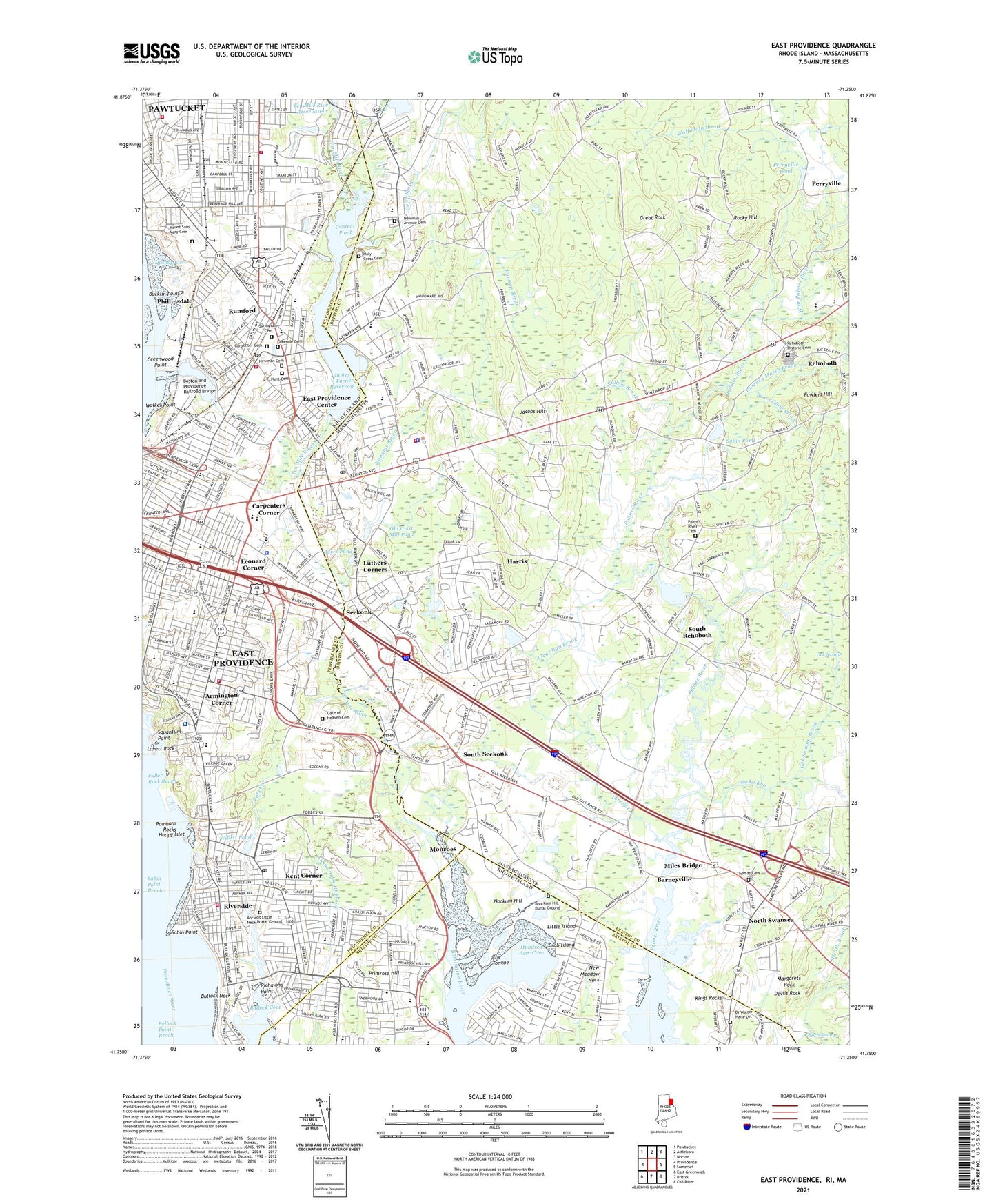
2024 topographic map quadrangle East Providence in the states of Massachusetts, Rhode Island. Scale: 1:24000. Based on the newly updated USGS 7.5' US Topo map series, this map is in the following counties: Providence, Bristol. The map contains contour data, water features, and other items you are used to seeing on USGS maps, but also has updated roads and other features. This is the next generation of topographic maps. Printed on high-quality waterproof paper with UV fade-resistant inks.
Quads adjacent to this one:
West: Providence
Northwest: Pawtucket
North: Attleboro
Northeast: Norton
East: Somerset
Southeast: Fall River
South: Bristol
Southwest: East Greenwich
Contains the following named places: Agawan Hunt Club Golf Course, Alice M Waddington School, Ancient Little Neck Burial Ground, Armington Corner, Austin T and June Rockwell Levy Library, Barneyville, Barrington Christian Academy, Barrington College, Barrington Early Childhood Center, Beaverdam Brook, Belton Court, Birch Swamp, Birch Swamp Corner, Bishop Cove, Bishop Point, Boston and Providence Railroad Bridge, Boyden Heights, Bradley School, Bright Futures Child Care Center, Brightridge School, Brown Play School, Bucklin Point, Bullock Cove, Bullock Neck, Burns School, Burrs Pond, Carpenter Brook, Carpenter Cemetery, Carpenters Corner, Central Pond, Child Care Connection of East Providence, Child Care Connection of East Providence Part II, City of East Providence, City of Pawtucket, Clear Run Brook, Coles Brook, Covenant Cooperative Nursery School, Crab Island, Cranberry Island, Crescent Park, Crestwood Country Club, Daggett House and Loof Carousel, Darlington Early Childhood Center, Darlington Post Office, Devils Rock, District Six Schoolhouse, Doctor Kevin M Hurley Middle School, Dorothy L Beckwith School, Dr Walter Haile Lot, Dunnell Park, Dunnell Print Works, East Bay Post Office, East Branch Palmer River, East Providence, East Providence Area Career and Technical Center, East Providence Center, East Providence Early Childhood Center, East Providence High School, Edward R Martin Junior High School, Emma G Whiteknact School, Emma Pendleton Bradley Hospital, Fallon School, Firefly Country Club, Fowlers Hill, Fuller Branch East Providence Public Library, Fullers Brook, Gate of Heaven Cemetery, George R Martin School, Gordon School, Grassy Plains Park, Great Rock, Green School, Greenwood Point, Grove Avenue School, Haines Memorial State Park, Hampden Meadows, Hampton Meadows School, Happy Islet, Harris, Holy Cross Cemetery, Hundred Acre Cove, Hunts Mill, Ingrams Corner, Jacobs Hill, James R D Oldham School, James V Turner Reservoir, James V Turner Reservoir Dam, Kent Corner, Kent Heights, Kent Heights School, Kings Rocks, Lakeside Cemetery, Lakeside Shopping Center, Ledgemont Country Club, Leonard Corner, Little Island, Luthers Corners, Margarets Rock, Mason Barney School, Masonic Lodge, McCoy Stadium, Meadowcrest School, Meeting Street School, Mildred H Aitken School, Miles Bridge, Monroes, Montessori Centre of Barrington, Mount Saint Mary Cemetery, Myron J Francis Elementary School, Narragansett Park Plaza Shopping Center, Narragansett Rack Track, New Meadow Neck, Newman Cemetery, Nockum Hill, North Swansea, Oak Swamp, Oak Swamp Brook, Old Grist Mill Pond, Old Thomas Cemetery, Omega, Omega Pond, Omega Pond Dam, Orchard Street School, Orlo Avenue School, Osamequin Nature Trails and Bird Sanctuary, Our Lady of Loreto School, Palmer River School, Palmer's River Churchyard Cemetery, Pawtucket Country Club, Peck Corner, Perryville, Perryville Pond, Phillipsdale, Pleasant School, Poham Rocks Light House, Pomham Rocks, Primrose Hill, Primrose Hill School, Providence Country Day School, Red Brick Nursery School, Rehoboth Country Club, Rhode Island Watercolor Society, Richmond Point, Riverside, Riverside Branch East Providence Public Library, Riverside Field, Riverside Junior High School, Riverside Post Office, Rocky Hill, Rocky Run, Rumford, Rumford Branch Library East Providence Public Library, Rumford Chemical Works and Mill House Historic District, Rumford Historic District, Rumford Post Office, Rumney Marsh Brook, Runnins River, Sabin Point, Sabin Point Park, Sabin Point Reach, Sabin Pond, Saint Brendans School, Saint Josephs School, Saint Lukes School, Saint Margarets School, Saint Marys School, Saint Theresa School, Seekong Senior High School, Seekonk, Seekonk Cemetery, Seekonk Fire Department, Seekonk Fire Department Headquarters, Seekonk Middle School Library, Seekonk Police Department, Seekonk Post Office, Seekonk Public Library, Seekonk Townhall, Shad Factory Pond, Shad Factory Pond Dam, Silver Spring, Silver Spring Golf Course, Silver Spring School, Six Corners, Slater Memorial Park, South Coast Educational Collaborative School, South Rehoboth, South Seekonk, Sowans Elementary School, Sowans Playground, Springvale Cemetery, Squantum, Squantum Point, Squantum Woods State Park, Starve Goat Island, Sun Valley Golf Club, Ten Mile Reservation Dam, Ten Mile River, The Little Red Schoolhouse, The Montessori School, The Red Brick Nursery, The Tongue, Thompson School, Torrey Creek, Tots Cooperative Nursery School, Town of Seekonk, Union School, Valley Community School, Vals Creek, Village Cemetery, Vue de l'eau, W R Watters School, Walker Point, Walkers Farm, Wampanoag Mall Shopping Center, Wannamoisett Country Club, WBRU-FM (Providence), WEAN-AM (Providence), West Branch Palmer River, WHIM-AM (East Providence), WHIM-AM (Providence), WHJJ-AM (Providence), WHJY-FM (Providence), Whortleberry Island, Willett Pond, WJAR-TV (Providence), Wolf Plain Brook, WPRO-AM (Providence), WSNE-FM (Taunton), WSTG-TV (Providence), YMCA Camp, Zion Bible Institute Library, ZIP Codes: 02771, 02914, 02915, 02916