MyTopo
Narragansett Pier Rhode Island US Topo Map
Couldn't load pickup availability
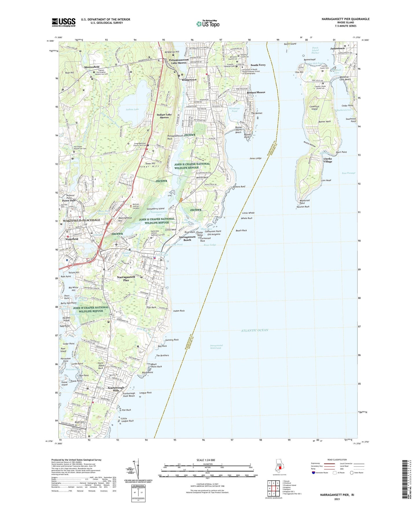
2021 topographic map quadrangle Narragansett Pier in the state of Rhode Island. Scale: 1:24000. Based on the newly updated USGS 7.5' US Topo map series, this map is in the following counties: Washington, Newport. The map contains contour data, water features, and other items you are used to seeing on USGS maps, but also has updated roads and other features. This is the next generation of topographic maps. Printed on high-quality waterproof paper with UV fade-resistant inks.
Quads adjacent to this one:
West: Kingston
Northwest: Slocum
North: Wickford
Northeast: Prudence Island
East: Newport
South: Narragansett Pier OE S
Southwest: Kingston OE S
Contains the following named places: A Place to Grow, Adventureland Amusement Park, Artillery Park, Austin Hollow, Bass Rock, Beach Rock, Beaver Neck, Beaverhead, Beavertail Light, Beavertail Point, Bedrock Farm, Belmont Shoppers Park Shopping Center, Benjamin Stanton Lot, Big White Hill, Black Point, Black Point Rock, Bluff Hill, Bog Rock, Boiling Lot Cove, Bonnet Point, Bonnet Shores, Bonnet Shores Beach, Boston Neck, Bradley School, Brenton Reef Light Ship, Bridgetown, Broad Rock Middle School, Camp Saugatucket, Canochet Memorial, Captain Christopher Gardner Lot Cemetery, Captain Josiah Arnold Lot, Cautantowwit's Indian Lot Cemetery, Cedar Point, Central Baptist Church, Central Street Historic District, Champlin Cove, Clarks Village, Clump Rocks, Cojoot Mine, Colonial Shopping Center, Conanicut Battery, Congregational Church Yard Cemetery, Conochet Club Beach, Cormorant Point, Cormorant Rock, Cottrell Green Cemetery, Creative Activities Center, Crooked Brook, Crying Bog, Dale Carlia Shopping Center, Daughters of the American Revolution Memorial, Dead Man Brook, Dickens Reef, Dunes Club Beach, Dutch Island Harbor, Dutch Island Light, Earlscourt Historic District, Fifth Avenue School, Fishermans Memorial State Park, Flat Rock, Fort Nathaniel Greene, Fort Philip Kearney, Fox Hill, Fox Hill Pond, Frank Point, Franklin - Gardiner Cemetery, Fresh Meadow Brook, Gin Spring, Goose Island, Gooseberry Island, Growing Children of Rhode Island Day Care Center, Gunning Rock, Harbour Island, Hazard School, Health Center of South County, Honorable Elisha Watson Lot Cemetery, Honorable William Robinson Lot Cemetery, Horseshoe Point, Hull Cove, Immaculate Conception Academy, Indian Lake, Indian Lake Dam, Indian Lake Shores, Indian Rock, Indian Run, Indian Run Reservoir, Iron Mine Cove, Jamestown Library, Jamestown Museum, Jamestown Post Office, Jamestown Primary School, Jamestown School at Lawn, Jamestown Wastewater Treatment Facility, Jamestown-Lawn School, John H Chafee National Wildlife Refuge, Jones Ledge, Judith Pond, Kingston Hill Academy, Lake Canonchet, Lanquissy Rocks, League Rock, Lion Head, Little League Rock, Little Neck, Little Neck Point, Little Neck Pond, Little Whale, Locke Point, Long Bar Point, Long Cove, Lower Point Judith Schoolhouse, Mackeral Cove Beach, Mackerel Cove, McSparran Hill, Meetinghouse Hill, Monsignor Matthew F Clarke Catholic Regional School, Mooresfield, Mount Zion African Methodist Episcopal Church, Narragansett Beach, Narragansett Chamber of Commerce Information Center, Narragansett Church, Narragansett Elementary School, Narragansett Ferry, Narragansett Fire Department Station 1, Narragansett Fire Department Station 2, Narragansett Fire Department Station 3, Narragansett High School, Narragansett Indian Monument, Narragansett Marine Lab, Narragansett Pier, Narragansett Pier Census Designated Place, Narragansett Pier Life Saving Station, Narragansett Pier School, Narragansett Police Department, Narragansett Post Office, Narragansett Public Library, Narragansett Town Hall, Newton Rock, Ocean Road Historic District, Old Antgonio, Old Daniel Rock, Old Mountain Field, Peace Dale, Peace Dale Congregational Church, Peace Dale Early Learning Center, Peace Dale Museum of Primitive Culture and Nineteenth Century Mill Village, Peace Dale Pond Dam, Pell Library National Sea Grant Depository Library, Pettaquamscutt Cove, Pettaquamscutt Lake Shores, Pettaquamscutt Park, Pettaquamscutt River, Pettaquamscutt Rock, Pickerel Point, Point Judith Country Club, Point Judith Neck, Quahaug Rock, Ragged Limb Ledge, Ram Head Point, Ram Island, Ram Point, River Ledge, River Rock, Riverside Cemetery, Robinson Street Post Office, Rocky Island, Rodman Crossing, Rose Hill, Round Rock, Rye Point, Saint Mary Star of the Sea Roman Catholic Church, Saint Peters By-The-Sea Episcopal Church, Saint Peters Play School, Saint Savios Boys Center, Saint Thomas More Church, Salt Pond Shopping Center, Saugatucket Pond, Saugatucket River, Scallop Shell Day Care Center, Scarborough Hills, Scarborough South State Beach, Scarborough State Beach, Schoolhouse Number 2, Sea Breeze Early Learning Center, Sedge Beds Island, Sheffield Cove, Short Point, Silver Lake, Silver Spring Cove, South County Church of Christ, South County Hospital, South County Hospital Airport, South County Museum at Conochet Farms, South Ferry, South Kingston High School, South Shore School, Southern Rhode Island Regional Collaborative School, Southwest Point, Sprague Memorial Field, Sprague Park, Sprague Pond, Spring Cove, State Pier Number 5, Stone Water Fence Cove, Stub Tree Bar, Tallow Hill, The Bonnet, The Brothers, The Narrows, The Prout School, The Towers, The Wakefield Mall Shopping Center, Thule Cove, Timothy Collins Lot, Tower Hill, Tower Hill Fire Department, Tower School, Towers Historic District, Town of Narragansett, Union Fire District South Kingstown Forest Fire Service, Union Fire District Wakefield Station, University of Rhode Island Bay Campus, University of Rhode Island Coastal Institute on Narragansett Bay Conference and Visitor Center, Upper Pond, Wakefield Mill Reservoir, Wakefield Post Office, Watson Pier, Welcome Cove, Wesquage Pond, Whale Rock, Whale Rock Light, Wheatfield Cove, Wolcott Cove, YMCA of South County, ZIP Code: 02882