MyTopo
Slocum Rhode Island US Topo Map
Couldn't load pickup availability
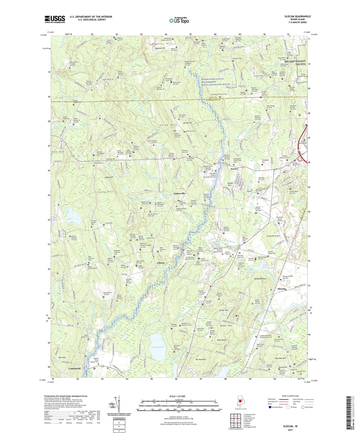
2021 topographic map quadrangle Slocum in the state of Rhode Island. Scale: 1:24000. Based on the newly updated USGS 7.5' US Topo map series, this map is in the following counties: Washington, Kent. The map contains contour data, water features, and other items you are used to seeing on USGS maps, but also has updated roads and other features. This is the next generation of topographic maps. Printed on high-quality waterproof paper with UV fade-resistant inks.
Quads adjacent to this one:
West: Hope Valley
Northwest: Coventry Center
North: Crompton
Northeast: East Greenwich
East: Wickford
Southeast: Narragansett Pier
South: Kingston
Southwest: Carolina
Contains the following named places: Albert Farms Airport, Albert Sweet Lot Cemetery, Amos Whitford Lot Cemetery, Anthony - Arnold Plot, Arnold - Harrington Lot Cemetery, Arnold - Sherman Lot Cemetery, Arrow Swamp, Asel Bates Lot Cemetery, Augustus Sweet Lot Cemetery, Austin - Hopkins Lot Cemetery, Baptist Plantations, Barber Pond, Bear Swamp, Benjamin Lawton Lot Cemetery, Benjamin Potter Lot Cemetery, Beriah Hopkins Lot Cemetery, Big River State Management Area, Braman Lot Cemetery, Burlingame Brook, Caleb Cooke Lot Cemetery, Camp Fire Girls Camp, Captain Henry Reynolds Lot Cemetery, Captain John Wells Lot Cemetery, Card Plot Cemetery, Carr - Rathbun Lot Cemetery, Casey Hill, Champlin Greene Burial Ground Cemetery, Champlin Lot Cemetery, Chestnut Hill Baptist Church, Chestnut Hill Cemetery, Chestnut Hill School, Congdon River, Cooks Corner, Cornelius Clark Lot Cemetery, Cranstons Corner, Daniel Dawley Lot Cemetery, Dawley - Straight Lot Cemetery, Dawley Brown Plot Cemetery, Dawley Pond, Dead Swamp, Doctor Joseph H Ladd School, Dowley Plot, Dugway, Dumping Rock, Dutemple Brook, Eben Henry Lot Cemetery, Eber J Sherman Plot, Eber Sherman Lot, Eber Sherman Plot, Edwards Pond, Elezer Slocum Plot, Exeter, Exeter Census Designated Place, Exeter Country Club, Exeter Fire Department No 1 Station 4, Exeter Hill, Exeter Historical Cemetery 51, Exeter Historical Cemetery 55, Exeter Patrol Barracks, Exeter Post Office, Exeter Rescue Squad, Exeter School Cemetery, Exeter Town Constable, Exeter Town Hall, Exeter Volunteer Company Number 1, Exeter Volunteer Fire Department Number 1, Fisherville, Fisherville Brook, Fisherville Brook Wildlife Refuge, Frenchtown Baptist Church, Frenchtown School for Young Children, Gardiner Lot, Gardner Lot Cemetery, Gardner Servant Lot Cemetery, Gardners Corner, Glen Rock, Glen Rock Brook, Glen Rock Reservoir, Glen Rock Reservoir Dam, Goose Nest Spring, Hall School, Hallville Pond, Hamiltons Corner, Hazard Sherman Plot, Henry Albro Lot Cemetery, Henry Briggs Lot Cemetery, Hitty Corner School, Hopkins Hill, Hopkins Lot Cemetery, Horn Heap, Huckleberry Hill, Hundred Acre Pond, Indian Rock Cemetery, Isaac Johnson Lot, James Ray Lot Cemetery, John Chapman Cemetery, John Gardner Lot Cemetery, John Sherman Lot Cemetery, John Sweet Lot Cemetery, Jonathan Sherman Lot Cemetery, Joseph Tisdale Lot Cemetery, Kenyon Grist Mill, Lafayette State Trout Hatchery, Liberty, Liberty Church, Locke Brook, Locke Swamp, Manton Free Library, Metcalf Wildlife Marsh, Metcalf Wildlife Marsh Dam, Millbrook Pond Dam, Miskiania Camp, Molasses Pardon Tillnghast Lot Cemetery, Money Swamp, Money Swamp Pond, Moses Barber Lot Cemetery, Mount Pleasant, Mud Brook, Narrow Lane Farm, Nathan Hathaway Lot Cemetery, Nicholas Bates Lot Cemetery, Niles Nichols Congdon Lot Cemetery, Noel Allen Lot Cemetery, Nooseneck River, Oak Harbor Village Shopping Center, Old Baptist Church Yard Cemetery, Old Exeter Poor Farm, Old Gardner Cemetery, Pardon Tillinghast Lot Cemetery, Pedigreen Tripp Lot Cemetery, Peleg Wood Lot Cemetery, Pendock Brook, Pepper Pond Camp, Phillips Cemetery, Pine Hill, Pine Hill Lookout Tower, Places Corner, Preacher Smart Lot, Queen River, Queens Fort, Queens Fort Brook, Queens River Baptist Cemetery, Rake Factory Brook, Rathbon Pond, Reuben Brown Brook, Reverend Solomon Sprague Lot Cemetery, Rhode Island State Hospital, Rhode Island Veterans Memorial Cemetery, Richard Briggs Lot Cemetery, Richmond Grange, Robbers Corner, Robert Gardner Lot Cemetery, Robert Willcox Lot Cemetery, Rolling Greens Golf Course, Rose Cemetery, Rose Lot Cemetery, Rothburn Cemetery, Samuel Arnold Plot Cemetery, Samuel S Whitford Lot Cemetery, Shebney Dawley Lot Cemetery, Sherman Brook, Sherman Burial Ground, Sherman Cemetery, Sherman Hill, Shrub Hill, Slocum, Slocum - Sweet Cemetery, Slocum Airport, Slocum Post Office, Slocum Reservoir, Slocum Reservoir Dam, Sodom Brook, South County Museum, Spencer Bentley Lot, State of Rhode Island and Providence Plantations, Stukely Brown Lot Cemetery, Stutley Tillinghast Lot, Sunderland Lot Cemetery, Sweet - Tripp Lot, The Reservoir, Theophilus Whale Lot Cemetery, Tillinghast Plot, Tillinghast Slave Lot, Tripps Corner, Usquepaug, Usquepaug Road Historic District, Vaughn Lot Cemetery, Walker Lot Cemetery, Warwick Sportsmans Club, Wawaloam School, Whitford Plot, Whitman - Thurston Lot Cemetery, Whitman - Wightman Lot Cemetery, Wightmans Corner, Wilcox - Durfee Lot Cemetery, Wilcox Lot Cemetery, William Gardiner Lot Cemetery, William Greene Lot Cemetery, William Potter Lot Cemetery, Wolf Rocks, Woods Corner, Yawgoo Mill Pond, Yawgoo Pond, Yawgoo School, Yawgoo Valley Ski and Recreation Area, Yorker Hill, Yorker Mill Pond Dam, Zebulan Gardner Lot Cemetery