MyTopo
Carolina Rhode Island US Topo Map
Couldn't load pickup availability
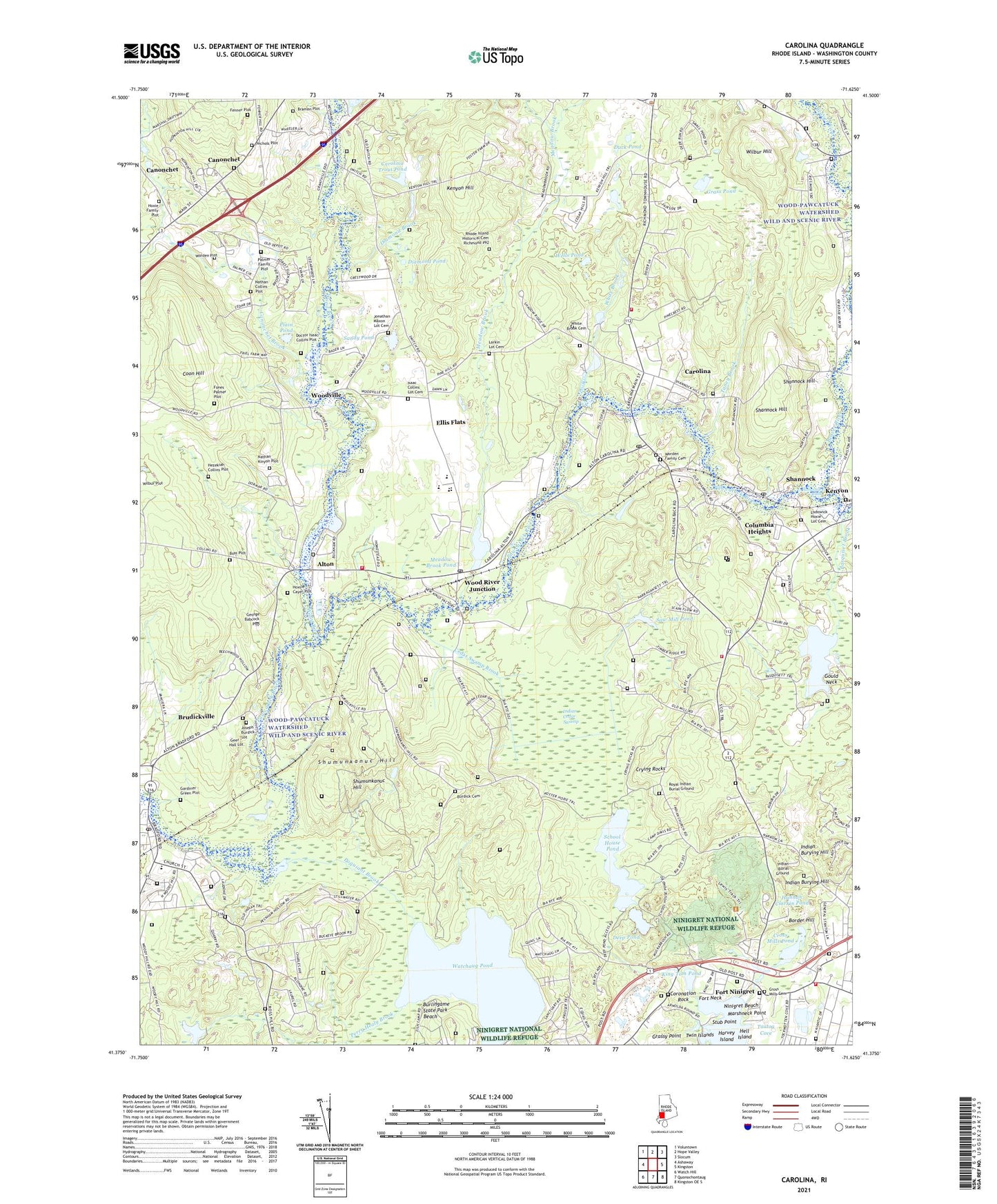
2024 topographic map quadrangle Carolina in the state of Rhode Island. Scale: 1:24000. Based on the newly updated USGS 7.5' US Topo map series, this map is in the following counties: Washington. The map contains contour data, water features, and other items you are used to seeing on USGS maps, but also has updated roads and other features. This is the next generation of topographic maps. Printed on high-quality waterproof paper with UV fade-resistant inks.
Quads adjacent to this one:
West: Ashaway
Northwest: Voluntown
North: Hope Valley
Northeast: Slocum
East: Kingston
Southeast: Kingston OE S
South: Quonochontaug
Southwest: Watch Hill
This map covers the same area as the classic USGS quad with code o41071d6.
Contains the following named places: Alton, Alton Pond, Alton Pond Dam, Arnolda, Beaver River, Black Farm State Management Area, Border Hill, Boulder HIlls Country Club, Bradford, Bradford Post Office, Bradford School, Bradford Volunteer Fire Department, Bramen Plot, Browning Isles, Brudickville, Burdick Cemetery, Burdickville, Burlingame State Management Area, Burlingame State Park, Burlingame State Park Beach, Canochet Station, Canonchet, Canonchet Brook, Carolina, Carolina Census Designated Place, Carolina Management Area, Carolina Post Office, Carolina Station, Carolina Trout Pond, Carolina Village Historic District, Carpenter Fenner Lot Cemetery, Cedar Swamp Brook, Chariho Area Career and Technical Center, Chariho Regional High School, Chariho Regional Middle School, Charlestown, Charlestown - Richmond Fire Station, Charlestown Census Designated Place, Charlestown Elementary School, Charlestown Historical Society Building, Charlestown Historical Society Schoolhouse, Charlestown School, Charlestown Town Hall, Church of the Holy Spirit, Clark Memorial Library, Columbia Heights, Coon Hill, Coronation Rock, Cross Mills Cemetery, Cross Mills Fire Station, Cross Mills Pond, Cross Mills Public Library, Crying Rocks, David Larkin Lot Cemetery, Deep Pond, Diamond Brook, Diamond Pond, District Schoolhouse Number 2, Doctor Isaac Collins Lot Cemetery, Duck Pond, Ellis Flats, Enchanted Forest, Fones Palmer Plot, Fort Neck, Fort Ninigret, Frosty Drew Memorial Nature Center, Frosty Drew Observatory, Gardiner - Green Lot Cemetery, Geer - Hall Lot Cemetery, George Babcock Lot Cemetery, Gould Neck, Grass Pond, Grassy Point, Hannah Clarkin Pond, Harvey Island, Hell Island, Hezekiah Collins Lot Cemetery, Hope Valley Wyoming Fire District Station 2, Horseshoe Falls, Horseshoe Falls Dam, Hoxsie - Cayer Lot Cemetery, Indian Burial Ground, Indian Burying Hill, Indian Cedar Swamp, Indian Cedar Swamp Management Area, Isaac Collins Lot Cemetery, Jonathan Maxon Lot Cemetery, Joseph Boss Lot Cemetery, Joseph Burdick Lot, Kenyon, Kenyon Hill, Kimball Wildlife Refuge, King Tom Pond, Lillibridge Pond, Lindhbrook Country Club, Meadow Brook, Meadow Brook Pond, Narragansett Indian Church, Narragansett Indian Longhouse and Cultural Center, Narragansett Reservation, Nathan Collins Plot, Nathan Kinyon Lot Cemetery, Nichols Plot, Ninigret Beach, Ninigret Park, Octagon House, Packer State Fishing Access, Palmer Family Plot, Pasquiset Brook, Pasquiset Pond, Perry Healy Brook, Perry Pond, Plain Pond, Poquiant Brook, Richmond - Carolina Fire District Station 1, Richmond Country Club, Richmond Historical Cemetery 92, Royal Burial Ground, Sahnnock Historic District, Saint Marys Church, Sandy Pond, Saw Mill Pond, School House Pond, Scotch Pond, Shannock, Shannock Hill, Shannock Mill Complex, Shannock Post Office, Shumunkanuc Hill, Stephen Hoxsie Lot Cemetery, Stub Point, Sullivan Quarries, Taney Brook, Tanyard Brook, Tautog Cove, Town of Richmond, Twin Islands, Watchaug Pond, Wells Pond, White Brook, White Brook Cemetery, Wilbur Hill, Wood River, Wood River Health Services, Wood River Junction, Wood River Junction Dam, Wood River Junction Post Office, Wood State Hunting and Fishing Area, Woodville, Woodville Pond, Woodville Pond Dam, Woody Hill State Management Area, Worden Family Cemetery, Worden Plot, Yawgunsk Brook, ZIP Codes: 02808, 02812, 02813, 02875, 02894