MyTopo
Blacksburg North South Carolina US Topo Map
Couldn't load pickup availability
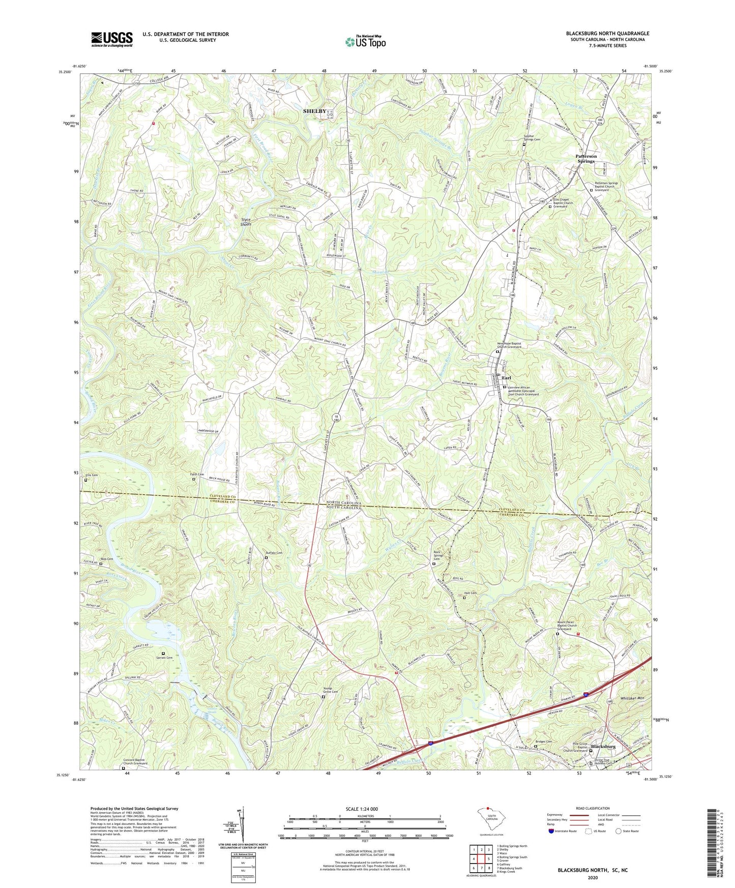
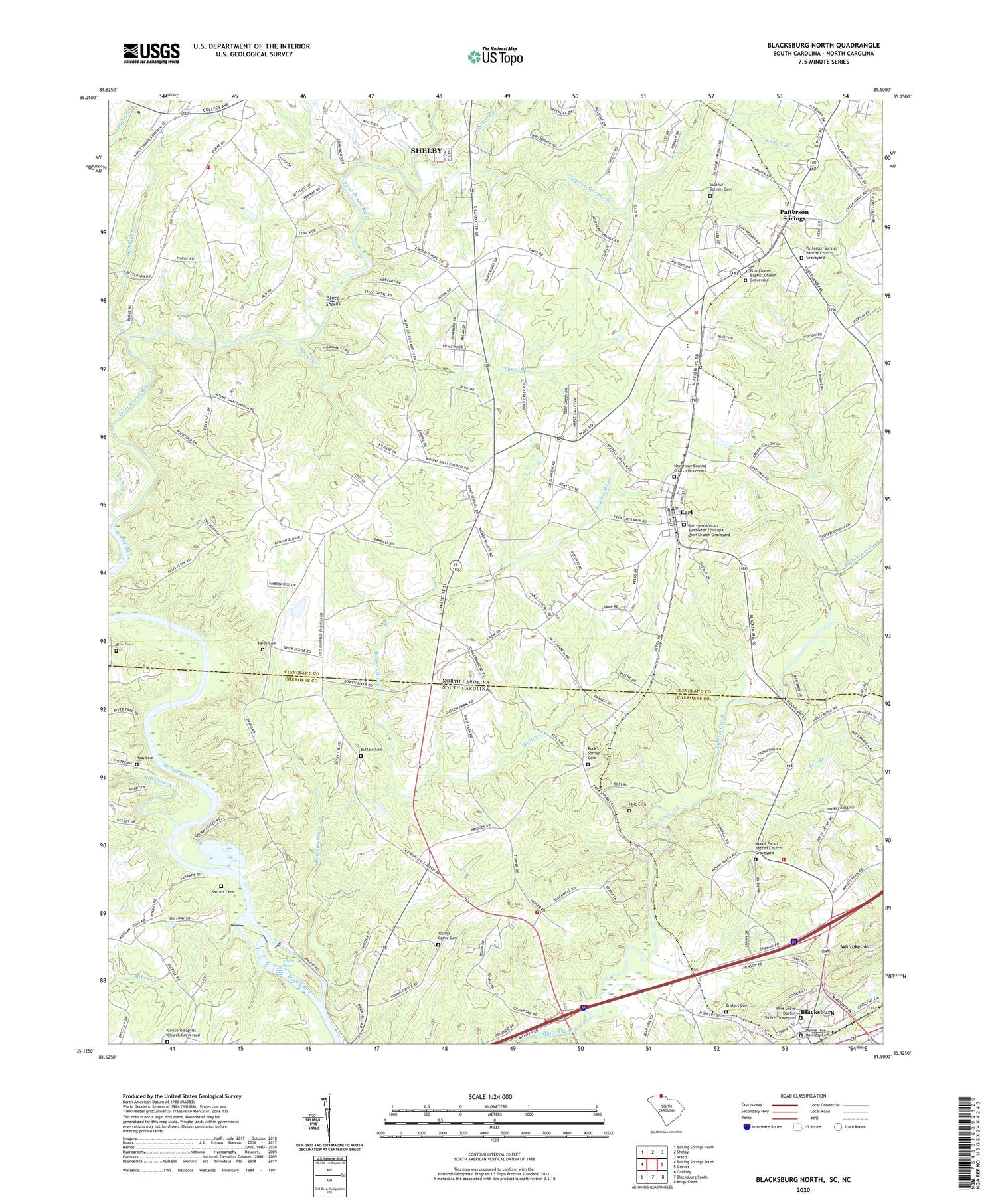
2020 topographic map quadrangle Blacksburg North in the states of North Carolina, South Carolina. Scale: 1:24000. Based on the newly updated USGS 7.5' US Topo map series, this map is in the following counties: Cherokee, Cleveland. The map contains contour data, water features, and other items you are used to seeing on USGS maps, but also has updated roads and other features. This is the next generation of topographic maps. Printed on high-quality waterproof paper with UV fade-resistant inks.
Quads adjacent to this one:
West: Boiling Springs South
Northwest: Boiling Springs North
North: Shelby
Northeast: Waco
East: Grover
Southeast: Kings Creek
South: Blacksburg South
Southwest: Gaffney
Contains the following named places: Bear Creek, Beaverdam Creek, Bee Branch, Big Bear Church, Bookout Dam, Bookout Lake, Bowens River, Bridges Cemetery, Broad River Academy, Buck Ford, Buffalo, Buffalo Baptist Church, Buffalo Cemetery, Buffalo School, Buffalo Volunteer Fire Department, Buffalo Volunteer Fire Department Substation, Cedar Grove Church, Cleveland County Emergency Medical Services Station 6, Concord Baptist Church, Concord Baptist Church Graveyard, Concord School, Davis Gin, Divine True Holiness Cemetery, Divine True Holiness Church of God, Earl, Earl Post Office, Earl School, Ellis Cemetery, Ellis Chapel Baptist Church Graveyard, Ellis Ferry, Erwinsville, Fairview African Methodist Episcopal Zion Church Graveyard, Fairview Church, Faith Baptist Church, Faith Cemetery, Fiber Industies Water Supply Dam, Fiber Industies Water Supply Lake, First Broad River, Gaston Shoals, Gaston Shoals Dam, Gaston Shoals Reservoir, Hawkins Branch, Hickory Creek, Holly Grove School, Holt Cemetery, Knox Surratt Dam, Knox Surratt Lake, Lick Branch, Logan Branch, Maple Springs Church, Mikes Creek, Mount Paran Baptist Church, Mount Paran Baptist Church Graveyard, Mount Saint Church, Mount Sinai, Mount Sinai Baptist Church, New Hope Baptist Church, New Hope Baptist Church Graveyard, New Life Mission, Number 3 School, Number Three Township Volunteer Fire Department, Oak Grove Church, Old Ellis Chapel, Patterson Springs, Patterson Springs Baptist Church, Patterson Springs Baptist Church Graveyard, Patterson Springs Elementary School, Pine Grove Baptist Church, Pine Grove Baptist Church Graveyard, Pine Grove Methodist Church, Pruette School, Rippys Township 3, Rock Springs Baptist Church, Rock Springs Cemetery, Rock Springs School, Ross Cemetery, Ross Creek, Sarratt Cemetery, Shanghai Volunteer Fire Department, Sharon, Shoal Creek, Shoal Creek Church, South Cleveland School, Stice Shoals Dam, Styce Shoals, Sulphur Springs, Sulphur Springs Branch, Sulphur Springs Cemetery, Sulphur Springs United Methodist Church, Thomason Store, Town of Earl, Town of Patterson Springs, Weavers Store, Whitaker Mountain, Wylies Creek, Yancey Creek, Young School, Youngs Grove Baptist Church, Youngs Grove Cemetery, ZIP Code: 28152