MyTopo
Edisto Island South Carolina US Topo Map
Couldn't load pickup availability
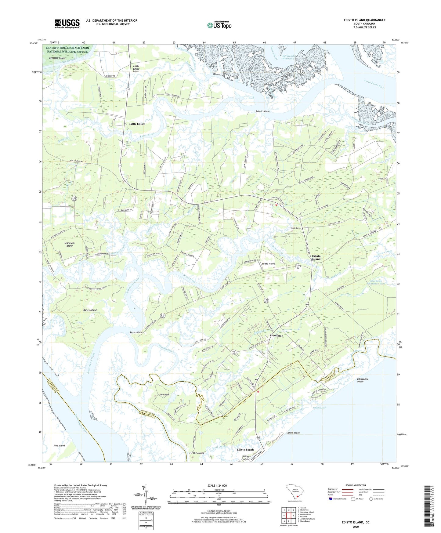
2020 topographic map quadrangle Edisto Island in the state of South Carolina. Scale: 1:24000. Based on the newly updated USGS 7.5' US Topo map series, this map is in the following counties: Charleston, Colleton. The map contains contour data, water features, and other items you are used to seeing on USGS maps, but also has updated roads and other features. This is the next generation of topographic maps. Printed on high-quality waterproof paper with UV fade-resistant inks.
Quads adjacent to this one:
West: Bennetts Point
Northwest: Fenwick
North: Adams Run
Northeast: Wadmalaw Island
East: Rockville
South: Edisto Beach
Southwest: Saint Helena Sound
Contains the following named places: Allen Church, Ashley Church, Bailey Creek, Bailey Island, Bethel Church, Bethlehem Church, Borough School, Brookland Plantation, Charleston County Sheriff's Office, Colleton County Fire Department, Dodge Plantation, Edings Island, Edingsville Beach, Edisto Beach Elementary School, Edisto Beach State Park, Edisto Church, Edisto Island, Edisto Island Church, Edisto Island Division, Edisto Island Library, Edisto Island School, Edisto Island Summary Court, Fishing Creek, Freedman, Galilee Church, Greater Calvary Church, Jane Edwards Elementary School, Jeremy Inlet, Larimer High School, Little Edisto, Little Edisto Island, Long Creek, Milton Creek, Mount Holly Church, Mount Olive Church, Mud Creek, Peters Point, Peters Point Plantation, Rabbits Point, Russel Creek, Saint Paul's Fire Department Edisto Island, Saint Pierre Creek, Sand Creek, Scanawah Island, Scott Creek, Sea Side School, Shingle Creek, Steamboat Creek, Steamboat Landing, Store Creek, The Edisto Island Museum, The Mound, The Neck, Trinity Cemetery, Trinity Church, Whooping Island Creek, Zion Church, ZIP Code: 29438