MyTopo
Greenville South Carolina US Topo Map
Couldn't load pickup availability
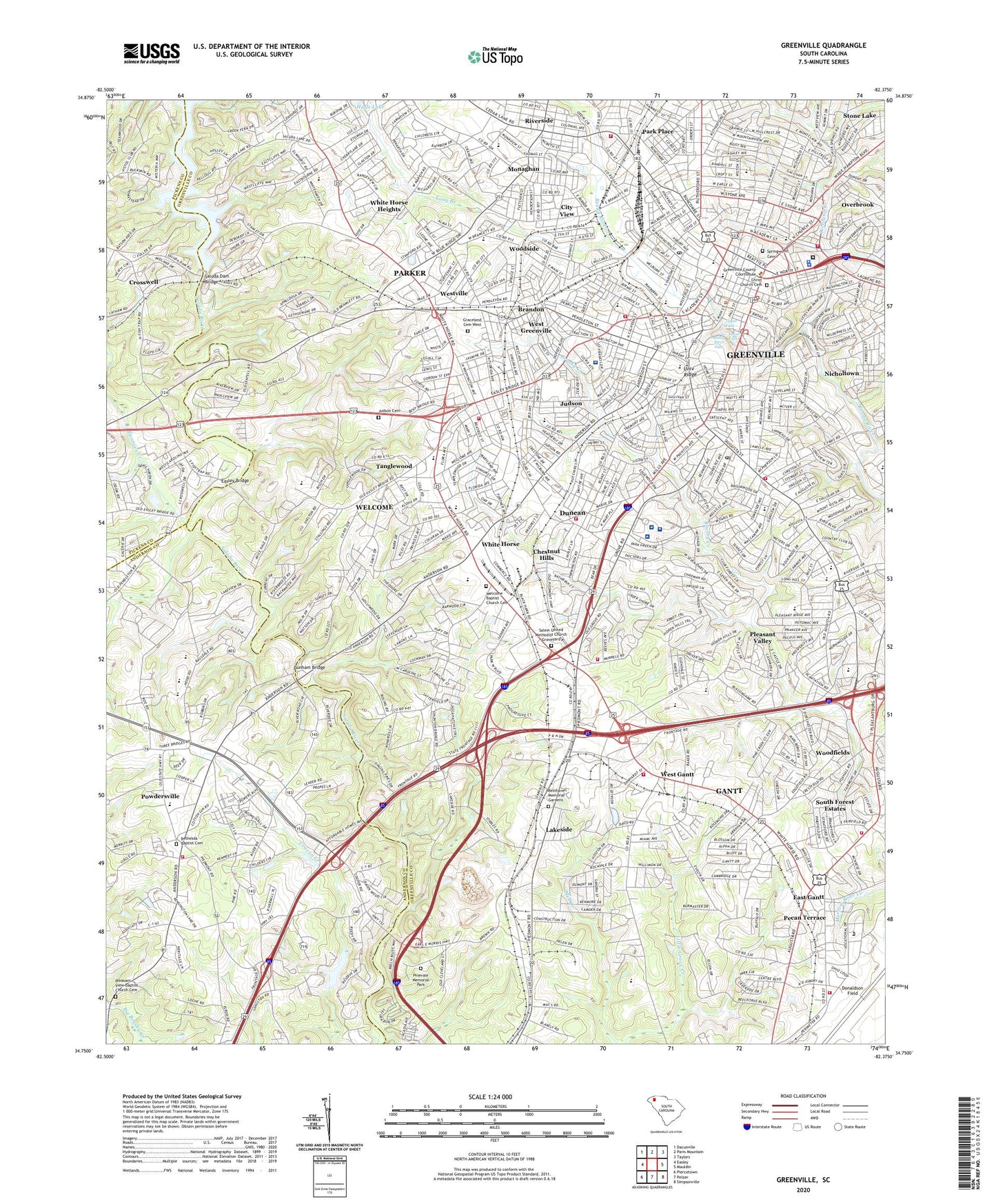
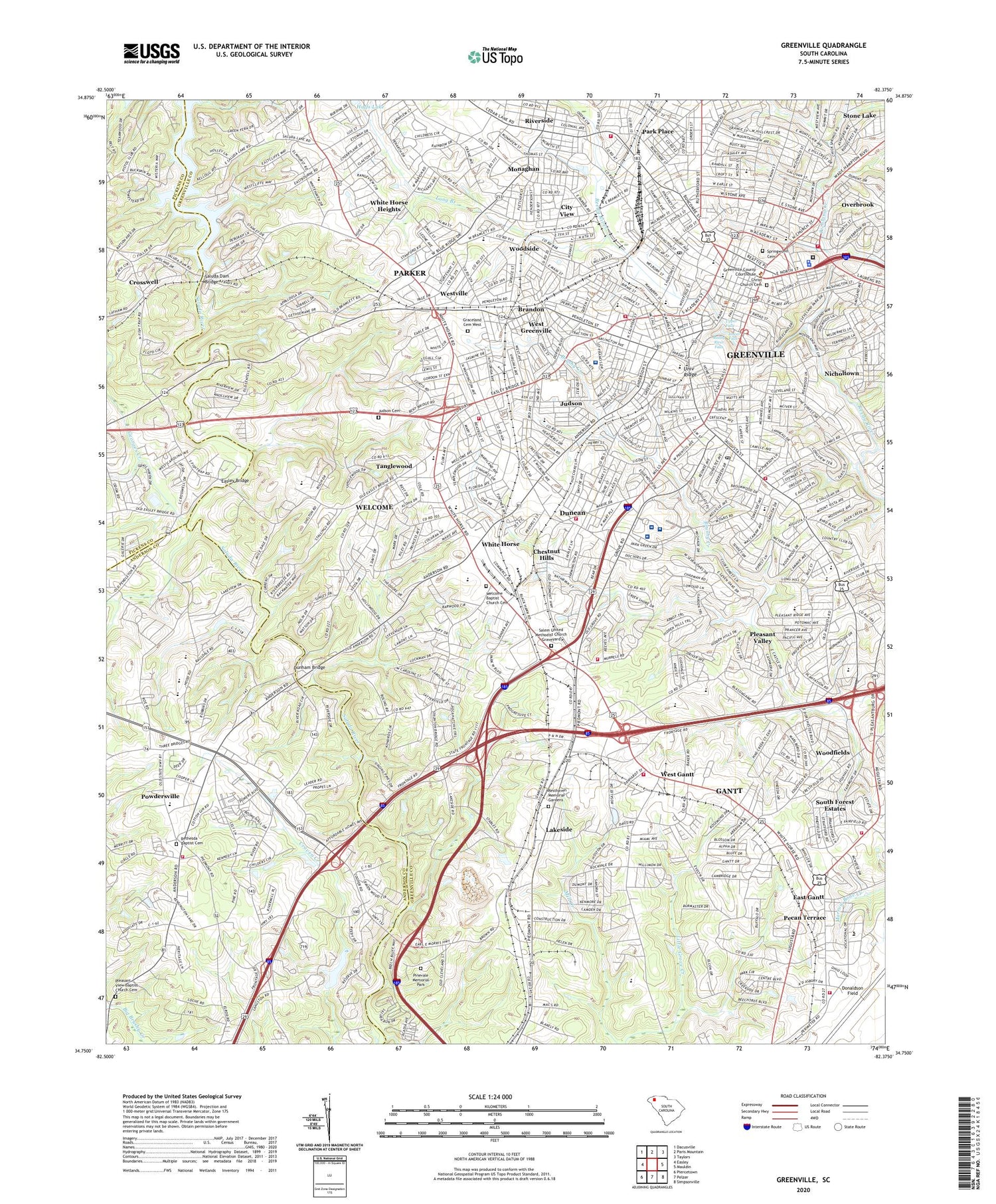
2020 topographic map quadrangle Greenville in the state of South Carolina. Scale: 1:24000. Based on the newly updated USGS 7.5' US Topo map series, this map is in the following counties: Greenville, Anderson, Pickens. The map contains contour data, water features, and other items you are used to seeing on USGS maps, but also has updated roads and other features. This is the next generation of topographic maps. Printed on high-quality waterproof paper with UV fade-resistant inks.
Quads adjacent to this one:
West: Easley
Northwest: Dacusville
North: Paris Mountain
Northeast: Taylors
East: Mauldin
Southeast: Simpsonville
South: Pelzer
Southwest: Piercetown
Contains the following named places: Alexander Elementary School, Alta Vista, Anderson Road Plaza Shopping Center, Arthur Black Park, Athelone Heights, Augusta Circle Elementary School, Augusta Road Park, Bakers Chapel School, Belaire Estates, Bell Plaza Shopping Center, Bell Tower Shopping Center, Belle Meade, Berea High School, Beth Israel Cemetery, Bethesda Baptist Cemetery, Bible College, Biltmore, Blythe School, Bon Secours Saint Francis Downtown Hospital, Boyce Lawn, Brandon, Brookforest Estates, Carolina Heights, Carolina High School, Carver Park, Catlin Park, Chanticleer, Chanticleer Country Club, Charles E Daniel Theatre, Chestnut Hills, Chicora College, Christ Church Cemetery, City View, City View Census Designated Place, Cleveland Forest, Cleveland Park, Club Forest, Colonel Elias Earle Historic District, Concrete Primary School, Cone Elementary School, Cross Creek Surgery Center, Crosswell, Crosswell School, Cutler Ridge, Donaldson Center Fire Department, Donaldson School, Donaldson Vocational Center, Dreher Colony, Dunean, Dunean Census Designated Place, Dunean Park, Dunham Bridge, Easley Bridge, East Gantt, Elizabeth Heights, Enchanted Forest, Fairfield Acres, Farmington Acres, Fine Arts Center, Furman University, Furman University Womens College, Gantt, Gantt Census Designated Place, Gantt Fire Department Station 1, Gantt Fire Department Station 2, Georges Creek, Glendale, Governors School for the Arts, Gower Child Development Center, Graceland Cemetery West, Green Forest Park, Greenview Elementary School, Greenville, Greenville City Hall, Greenville Country Club, Greenville County Courthouse, Greenville County Jail, Greenville County Library, Greenville County Public Health Center, Greenville Endoscopy Center - Saint Francis, Greenville Female College, Greenville High School, Greenville Memorial Hospital, Greenville Post Office, Greenville Surgery Center, Grove Elementary School, Grower Child Development Center, Hampton-Pinckney Historic District, Hayne School, Heritage Green, Hollis School, Holly Springs, Holmes Theological Seminary, Hughes Heights, Hughes Middle School, Interstate Industrial Park, Jervey Eye Group Greenville One Doctors Drive, John Street Primary School Number 1, Judson, Judson Cemetery, Judson Census Designated Place, Knollwood, Lady of the Rosary School, Lakeside, Lakeside Lake, Lakeside Park, Lakeside Quarry, Lewis Plaza Shopping Center, Lockwood Heights, Long Branch, Lower Falls, Mansfield Park, McBee Mill, McPherson Park, Meadowbrook Park, Memorial Auditorium, Mills Mill, Monaghan, Monaview School, Mountain View Homes, Nicholtown Child Development Center, North Hills, Oak Crest, Oak Hill School, Oscar Street School, Overbrook, Overbrook Child Development Center, Oxford Acres, Palmetto Heliport, Palmetto Terrace, Park Lane Terrace, Park Place, Parker, Parker Census Designated Place, Parker High School, Pecan Terrace, Pettigru Street Historic District, Phillis Wheatley Community Center, Piazza Bergamo, Pickens Hospital, Piedmont Industrial Park, Pine Hill Village, Pinevale Memorial Park, Plainview Heights, Pleasant Valley, Pleasant View Baptist Church Cemetery, Pleasantview School, Poe Mill Park, Poinsett, Poinsett School, Powdersville, Powdersville Census Designated Place, Powdersville Fire Department Station 7, Quail Haven, Reedy River Falls, Reedy River Falls Park, Reedy River Industrial District, Regency Hospital of Greenville, Resthaven Memorial Gardens, Richland Cemetery, Richland Creek, Riley Estates, Riverside, Rockvale, Rockwood Park, Roosevelt Heights, Roseman Heights, Royal Oaks, Saint Anthonys School, Saint Johns School, Saint Marys School, Saint Peters School, Salem United Methodist Church Graveyard, Saluda Dam, Saluda Dam Bridge, Saluda Lake, Sampson, Shriners Hospital for Children, Sirrine Elementary School, Sirrine Hospital, Sirrine Stadium, Smith Heights, South Carolina Noname 04003 D-3141 Dam, South Forest Estates, Southside High School, Spring Brook Terrace, Springwood Cemetery, Staunton Heights, Sterling High School, Stone Elementary School, Stone Lake, Sullivan Street Elementary School, Sunny Acres, Supreme Forest, Tanglewood, Tanglewood Middle School, Terrace Shopping Center, Textile Hall, The Highlands, Traxler Park, University Ridge, University Ridge Homes, Upper Falls, View Point Place, Watts Park, Welcome, Welcome Acres, Welcome Baptist Church Cemetery, Welcome Census Designated Place, Welcome School, West Gantt, West Gantt School, West Greenville, West Greenville Elementary School, Westcliff School, Westcliffe, Westside Park, Westville, WFBC-AM (Greenville), White Horse, White Horse Heights, White Horse Industrial District, White Oak Hills, Woodbriar, Woodfield Heights, Woodfields, Woodside, Woodside Cotton Mill Village Historic District, Woodson Pond, WPCI-AM (Greenville), WSSL-AM (Greenville), WTBI-FM (Greenville), ZIP Codes: 29601, 29605, 29611