MyTopo
Piercetown South Carolina US Topo Map
Couldn't load pickup availability
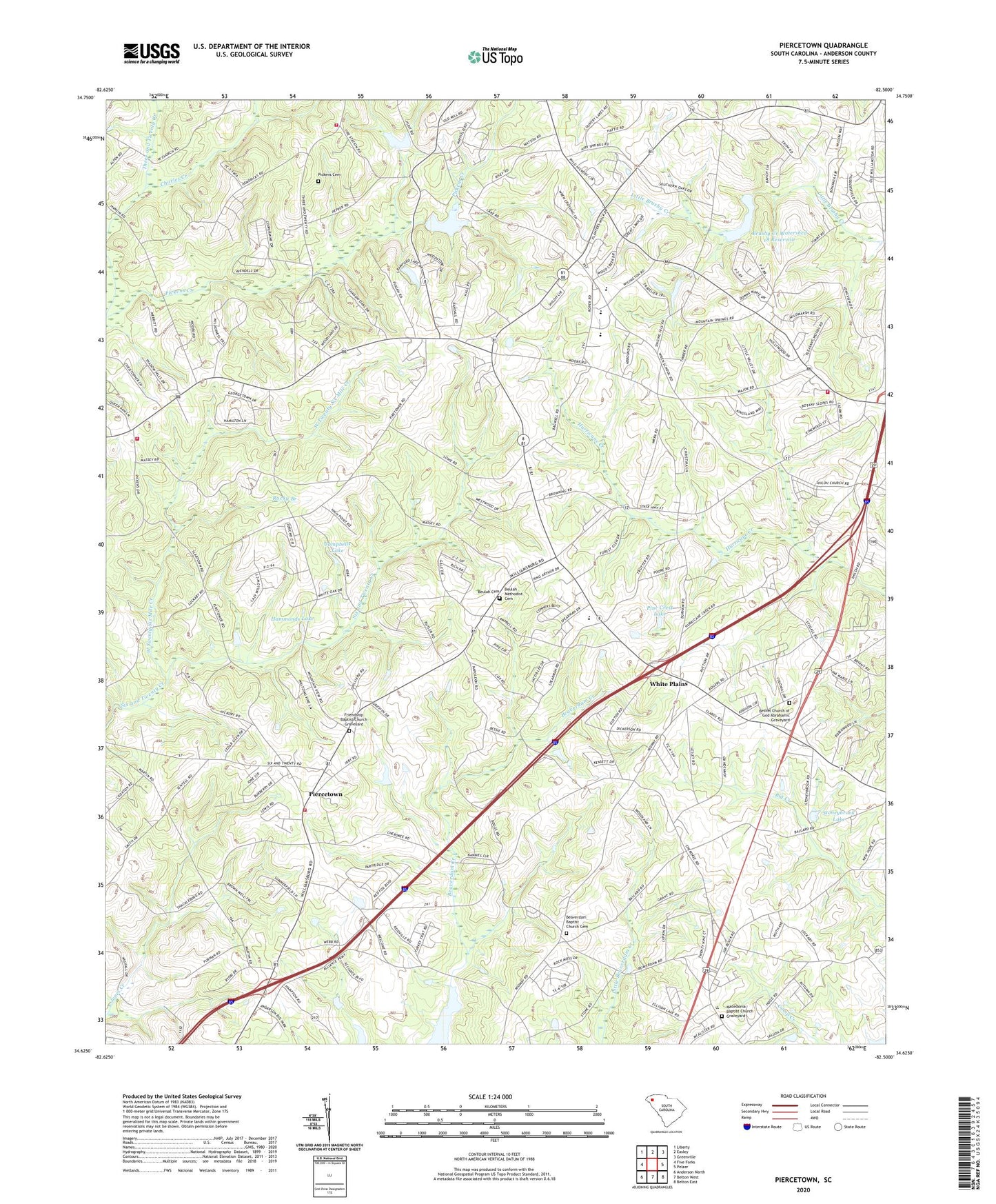
2024 topographic map quadrangle Piercetown in the state of South Carolina. Scale: 1:24000. Based on the newly updated USGS 7.5' US Topo map series, this map is in the following counties: Anderson. The map contains contour data, water features, and other items you are used to seeing on USGS maps, but also has updated roads and other features. This is the next generation of topographic maps. Printed on high-quality waterproof paper with UV fade-resistant inks.
Quads adjacent to this one:
West: Five Forks
Northwest: Liberty
North: Easley
Northeast: Greenville
East: Pelzer
Southeast: Belton East
South: Belton West
Southwest: Anderson North
This map covers the same area as the classic USGS quad with code o34082f5.
Contains the following named places: Airy Spring School, Anderson County Fire Department Slabtown Substation, Anderson County Fire Department Wren Station 24, Anderson Speedway, Battery Creek, Beaverdam Baptist Church Cemetery, Beaverdam Church, Bethel Church, Bethel Church of God Abrahamic Graveyard, Beulah Cemetery, Beulah Church, Beulah Methodist Cemetery, Blake Dale School, Brushy Creek Watershed 18 Reservoir, Campbells Lake, Central School, Charles Creek, Equality Post Office, Fairfield Church, Friendship Baptist Church, Friendship Baptist Church Graveyard, Gro-Mor Pond Dam D-3127, Guthrie Church, Guthrie Grove Church of God Cemetery, Guyton Post Office, Hammonds Lake, Hills Ranch Airport, Macedonia Baptist Church, Macedonia Baptist Church Graveyard, Maple Springs School, McGee Pond, Mount Airy Church, Mount Pisgah Baptist Church Graveyard, Mount Pisgah Church, Mount Pleasant Church, Mount Pleasant School, Mount View School, Mountain Spring Church, Mountain Springs Baptist Church Graveyard, New Mount Pisgah Baptist Church Graveyard, Pickens Cemetery, Pickens Chapel, Piercetown, Piercetown Fire Department - Anderson County Station 13, Piercetown School, Pine Crest Lake, Pisgah Church, Poplar Springs School, Powdersville-Piedmont Division, Rocky Branch, Shiloh Church, Sky Valley Airpark, Slabtown Academy, Slabtown Presbyterian Church, South Carolina Noname 04002 D-3128 Dam, South Carolina Noname 04007 D-3139 Dam, South Carolina Noname 04016 D-3132 Dam, South Carolina Noname 04017 Dam, South Carolina Noname 04030 D-3126 Dam, Spearman School, Stoneybrook Lake, Stringer Ridge Lookout Tower, Sweet Canaan Baptist Church Cemetery, Sweet Canaan Church, Three and Twenty Fire Department District 19, Three and Twenty School, West Twenty Six Mile Creek, White Plains, White Plains Church, White Plains School, White Sands Muster Ground, Wren Church, Wren High School, Wren Middle School, Wren Primary School, WWMM-FM (Anderson), ZIP Code: 29697