MyTopo
Greer South Carolina US Topo Map
Couldn't load pickup availability
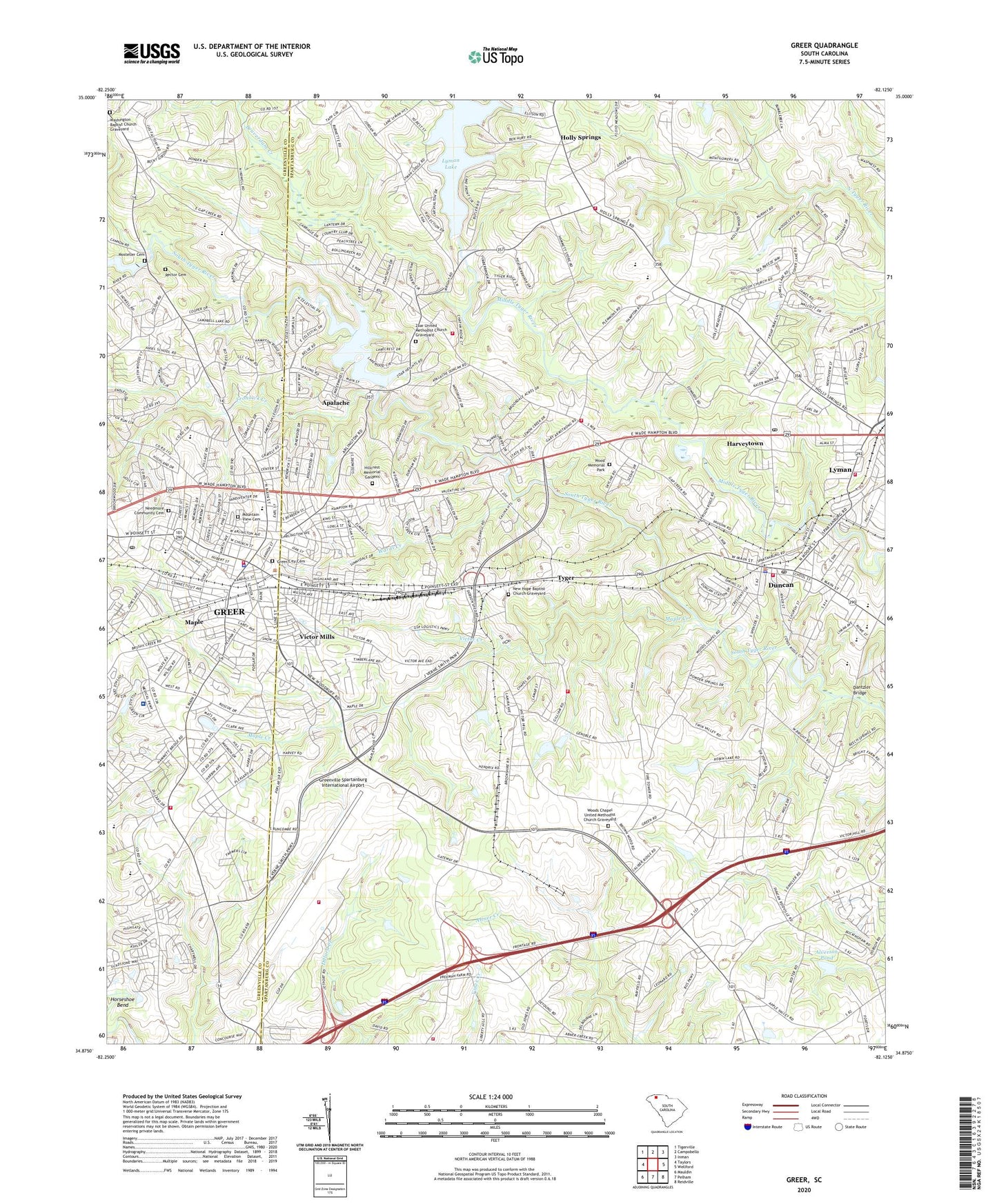
2020 topographic map quadrangle Greer in the state of South Carolina. Scale: 1:24000. Based on the newly updated USGS 7.5' US Topo map series, this map is in the following counties: Spartanburg, Greenville. The map contains contour data, water features, and other items you are used to seeing on USGS maps, but also has updated roads and other features. This is the next generation of topographic maps. Printed on high-quality waterproof paper with UV fade-resistant inks.
Quads adjacent to this one:
West: Taylors
Northwest: Tigerville
North: Campobello
Northeast: Inman
East: Wellford
Southeast: Reidville
South: Pelham
Southwest: Mauldin
Contains the following named places: A and G Shopping Center, Abner Creek Baptist Church Graveyard, Abners Creek Baptist Church, Alverson Pond, Alverson Pond Dam, Ansell School, Apalache, Apalache Park, Apalachee Mill Pond, Appalachee Mill, Ballenger School, Beaverdam Creek, Ben Edward Park, Bennett Hospital, Bonaire Acres, Brookdale, Brookhaven, Byrnes High School, Calina Heights, Calvary Church, Central School, Century Park, Chapel Estates, Cheryl Fields, Chestview Church, Chestview Elementary School, Church of Christ, Church of the Good Shepherd, City of Greer, City Park, Cokes Ridge Mobile Home Park, Country Club Estates, Crestview Hills, Dantzler Bridge, Davenport High School, Davenport Park, Dogwood Acres, Duke Street Elementary School, Duncan, Duncan Correctional Center, Duncan Elementary School, Duncan Fire Department Station 1, Duncan Fire Department Station 2, Duncan First Baptist Church Graveyard, Duncan Lookout Tower, Duncan Police Department, East Greer Elementary School, F McMackin Pond Dam D-3341, Fairway Estates, Faith Church, First Presbyterian Church, Flat Woods School, Forest Hills, Friendship Baptist Church Graveyard, Friendship Church, Friendship School, Frohawk Creek, Fulton Acres, Galloway Trailer Park, Grace Church, Grays Academy, Greentown Park, Greenville - Spartanburg Airport Fire Department, Greenville Health System Greer Medical Campus, Greenville Spartanburg International Airport, Greer, Greer Branch Library, Greer City Cemetery, Greer City Hall, Greer Country Club, Greer Division, Greer Fire Department Headquarters, Greer High School, Greer Middle School, Greer Plaza Shopping Center, Greer Police Department, Greer Post Office, Greer Shopping Center, Hall Church, Harveytown, Highland Cemetery, Highway 14 Industrial Park, Hill Middle School, Hillcrest Church, Hillcrest Memorial Gardens, Holiday Hills, Holly Hill Heights, Homewood Acres, Horseshoe Bend, Jetport Industrial Park, L M Dobson Pond Dam D-2743, Lakeview Heights, Lakewood Hills, Liberty Hill School, Lyman, Manning Acres, Maple, Maple Creek, Maple Hill School, Maplewood, Mayfield Chapel, Middleton Place Shopping Center, Midwood School, Mink Creek Estates, Moon Pond, Moon Pond Dam D-2911, Mosteller Cemetery, Mostellers Mill, Mountain View Cemetery, Needmore Community Cemetery, New Apostolic CHurch, New Hope Baptist Church Graveyard, New Hope Church, New Hope School, Northview Acres, Northwood Church, Oakwood, Palmetto Estates, Pelham - Batesville Fire Department Station 2, Pelham - Batesville Fire Department Station 4, Pelham Batesville Fire Department Station 4, Pinecrest, Piney Grove Church, Piney Grove School, Pleasant Grove, Pleasant Grove Church, Pleasant Grove School, R A Dodson Pond Dam D-3343, R E Collins Pond Dam D-3337, Rector Cemetery, Robinson Farms Pond Number One Dam D-2746, Robinson Farms Pond Number Two Dam D-2747, Rock Hill Church, Rotary Park, Serene Heights, Shiloh Church, Shiloh School, South Carolina Noname 42001 Dam, South Carolina Noname 42004 D-3340 Dam, Springwood Park, Square One Farmers Market, Stephens Park, Sunny Glen, Sunnyside Park, Teton Forest, Town of Duncan, Trade Street Place Mini Mall Shopping Center, Tryon Park, Tryon Street Elementary School, Turner Park, Tyger, Tyger River Fire Department Station 1, Tyger River Fire Department Station 2, Victor Creek, Victor Heights, Victor Mills, Victor Park, Victorian Hills, W D Glenn Pond Dam D-3344, Wade Hampton Heights, Wards Creek, Wards Creek Park, Washington Baptist Church Graveyard, Washington School, Wellford Division, Wesleyan Church, Wood Memorial Park, Woodland Elementary School, Woodland Forest, Woods Chapel Methodist Church, Woods Chapel United Methodist Church Graveyard, WPJM-AM (Greer), Zoar Heights, Zoar Methodist Church, Zoar School, Zoar United Methodist Church Graveyard, ZIP Code: 29365