MyTopo
Campobello South Carolina US Topo Map
Couldn't load pickup availability
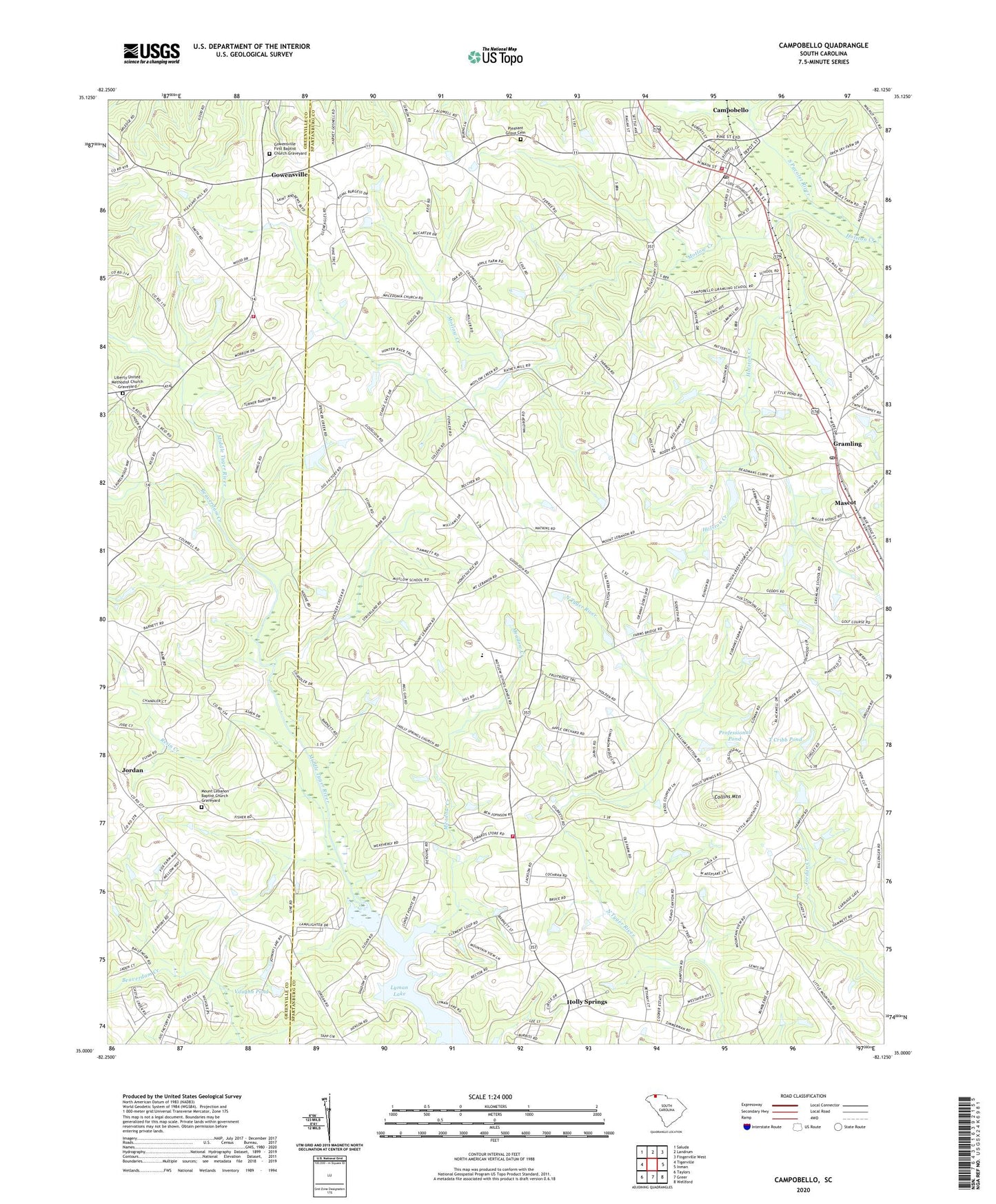
2024 topographic map quadrangle Campobello in the state of South Carolina. Scale: 1:24000. Based on the newly updated USGS 7.5' US Topo map series, this map is in the following counties: Spartanburg, Greenville. The map contains contour data, water features, and other items you are used to seeing on USGS maps, but also has updated roads and other features. This is the next generation of topographic maps. Printed on high-quality waterproof paper with UV fade-resistant inks.
Quads adjacent to this one:
West: Tigerville
North: Landrum
Northeast: Fingerville West
East: Inman
Southeast: Wellford
South: Greer
Southwest: Taylors
This map covers the same area as the classic USGS quad with code o35082a2.
Contains the following named places: Al Jones Pond Dam D-3339, Andover, Beaverdam Creek, Bethel Baptist Church Cemetery, Bethel Church, C Stewart Pond, C Stewart Pond Dam D-3394, Campobello, Campobello Airport, Campobello Fire Department, Campobello First Baptist Cemetery, Campobello Police Department, Campobello School, Campobello United Methodist Church Graveyard, Campobello-Gramling Elementary School, Carlisle Church, Collins Mountain, Corner Rosenwald Church, Corner Rosenwald School, E Lee Incorporated Pond, E Lee Incorporated Pond Dam D-3314, E Woodfin Lake, E Woodfin Lake Dam D-3309, Faith Missionary Church, Fellowship Church, Gowensville, Gowensville Church, Gowensville Fire Department Headquarters, Gowensville First Baptist Church Graveyard, Gramling, Gramling Brothers Lake Dam Five D-3311, Gramling Census Designated Place, Gramling Division, Gramling Number One Pond, Gramling Pond Dam Number One D-3307, Gramling Pond Number Four Dam D-3393, Gramling Pond Number Two Dam D-3308, Gramling Post Office, Gramling United Methodist Church Cemetery, H B Davis Pond, H B Davis Pond Dam D-3318, Henson School, Holly Springs, Holly Springs Church, Holly Springs School, Holly Springs Volunteer Fire Department, Holly Springs-Motlow Elementary School, Holston Creek, Holston Creek Baptist Church Graveyard, Holston Creek Church, Honey Tree School, J B Johnson Pond, J B Johnson Pond Dam D-3315, Liberty Church, Liberty United Methodist Church Graveyard, Little Chicago, Little Mountain Baptist Church Graveyard, Little Mountain Church, Lyman Lake, Lyman Quarry, Mabry Temple, Macedonia Church, Mascot, Meadow Creek, Motlow Creek, Motlow Creek Church, Motlow Creek School, Mount Lebanon Baptist Church Graveyard, Mount Lebanon Church, Mount Lebanon School, Mount Pilgrim Church, Mount Pilgrim Missionary Baptist Church Graveyard, Mount View Church, Pleasant Grove Cemetery, Pleasant Grove Church, Pleasant Grove School, Professional Pond, Professional Pond Dam D-3317, Resin Creek, Sloan Airport, T Cribb Pond, T Cribb Pond Dam D-2175, T Ragan Pond Dam, T Ragan Pond Dam D-3316, Tyger, Vaughn Pond, Vaughn Pond Dam D-2910, ZIP Code: 29322