MyTopo
Tigerville South Carolina US Topo Map
Couldn't load pickup availability
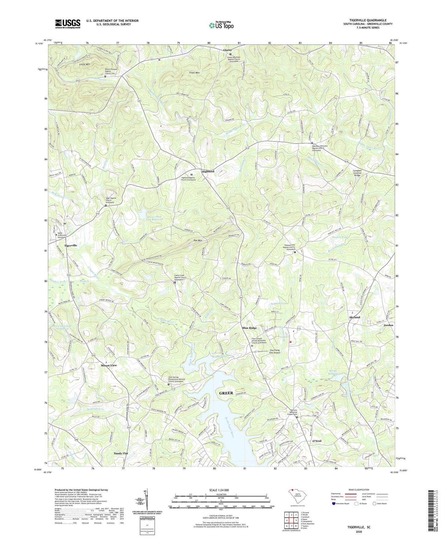
2024 topographic map quadrangle Tigerville in the state of South Carolina. Scale: 1:24000. Based on the newly updated USGS 7.5' US Topo map series, this map is in the following counties: Greenville. The map contains contour data, water features, and other items you are used to seeing on USGS maps, but also has updated roads and other features. This is the next generation of topographic maps. Printed on high-quality waterproof paper with UV fade-resistant inks.
Quads adjacent to this one:
West: Slater
Northwest: Zirconia
Northeast: Landrum
East: Campobello
Southeast: Greer
South: Taylors
Southwest: Paris Mountain
This map covers the same area as the classic USGS quad with code o35082a3.
Contains the following named places: Anthony Lake Dam Number One D-2885, Anthony Lake Dam Number Two D-2884, Barton Chapel, Barton Creek, Bartons Memorial Chapel Cemetery, Beaverdam Church, Berry Mill, Berrys Millpond, Bible Church, Blue Ridge, Blue Ridge Baptist Church Graveyard, Blue Ridge School, Bryant Pond, Bryant Pond Dam D-2891, Camp Creek Baptist Church Graveyard, Camp Creek Church, Campbell Covered Bridge, Campbell Creek, Church of God, Ebenezer Church, Ebenezer School, Ebenezer Welcome Baptist Church Graveyard, Edwards Lake, Emery Airport, Few School, Fews Chapel, Fews Chapel United Methodist Church Graveyard, Foyster Creek, Glassy, Glassy Mountain Baptist Church Graveyard, Glassy Mountain Church, Glassy Mountain Fire Department Headquarters, Glassy Mountain School, Gum Springs Church, Gum Springs Pentacostal Holiness Church Graveyard, Hayes Pond Dam D-2867, High Church, Highland, Highland Baptist Church Graveyard, Highland Church, Highland Division, Highland School, Hughey Pond, Jordan, Jordan School, L Cooper Pond Dam D-2882, Lake Cunningham Fire Department Station 2, Lake Robinson, Lendaw, Little Mountain, McKinney Creek, Meadow Fork, Mitchell, Mount Pleasant Baptist Church Cemetery, Mount Pleasant Church, Mount View, Mountain View Church, Mountain View Elementary School, Mush Creek, New Salem Church, Noe Creek, North Greenville Junior College, O Neal Field, O'Neal, O'Neal Detention Center, Pax Creek, Pax Mountain, Pleasant Hill, Pleasant Hill Baptist Church Graveyard, Pleasant Hill Church, Pleasant Hill School, Pleasant Mountain Church, Ridgill Lake Dam, Ridgill Pond, Robertson School, Rudolf Pond Dam D-2849, Saint Pauls Church, Salem School, Sandy Flat Quarry, Skyland, Skyland School, South Carolina Noname 23012 D-2883 Dam, South Tyger River WCD Dam 4c D-2915, Sudduth Pond, Taho, The Flying Few Airport, Thompson Branch, Tiger Eye School, Tigerville, Tigerville Census Designated Place, Tigerville Elementary School, Tillet Mountain, Tyger Baptist Church Graveyard, Tyger Church, Water Shed Five Reservoir, Welcome Home Church, Wilbanks Airport, Wildcat Creek, Woods Pond Dam D-2866, ZIP Code: 29651