MyTopo
Johns Island South Carolina US Topo Map
Couldn't load pickup availability
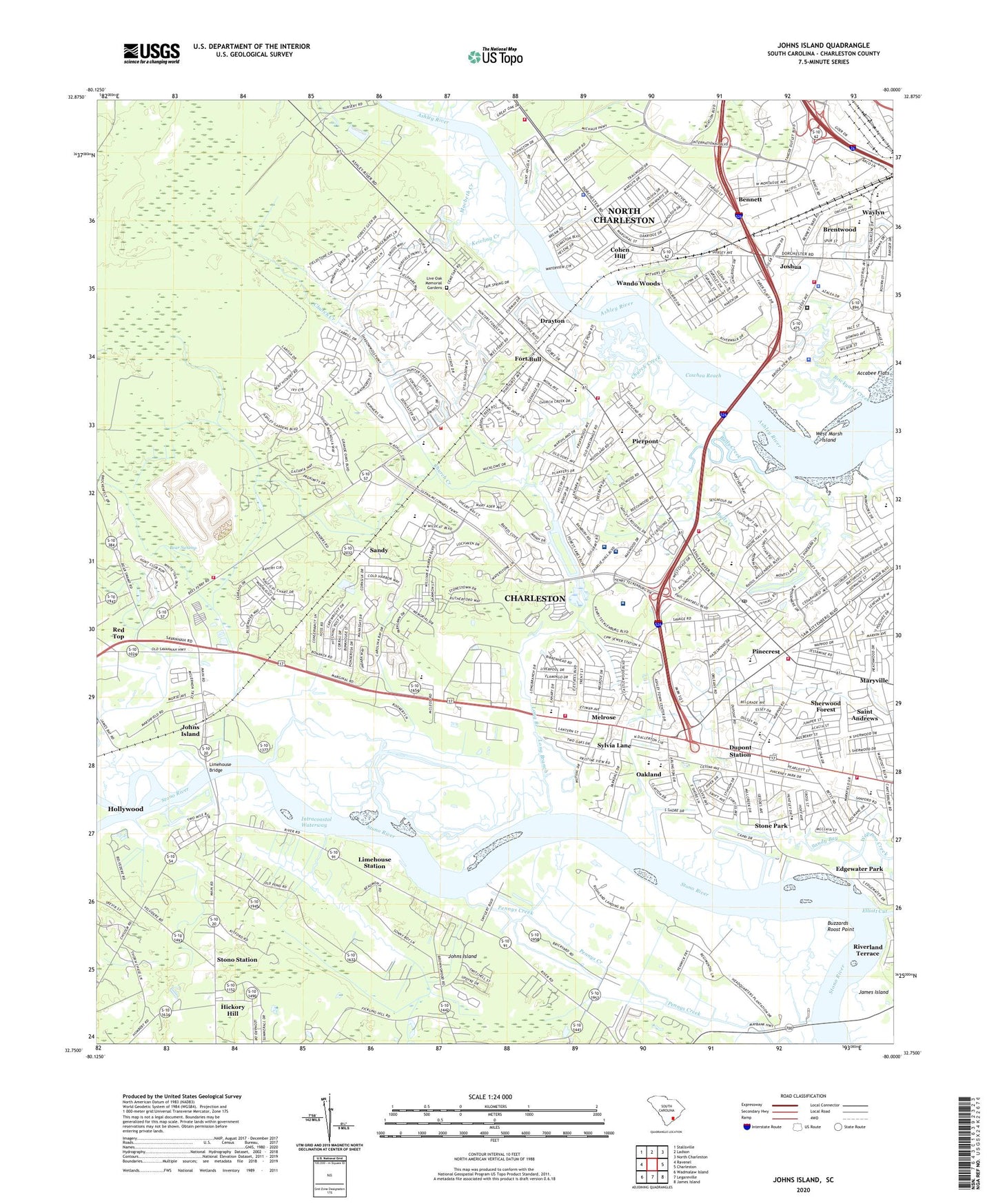
2020 topographic map quadrangle Johns Island in the state of South Carolina. Scale: 1:24000. Based on the newly updated USGS 7.5' US Topo map series, this map is in the following counties: Charleston. The map contains contour data, water features, and other items you are used to seeing on USGS maps, but also has updated roads and other features. This is the next generation of topographic maps. Printed on high-quality waterproof paper with UV fade-resistant inks.
Quads adjacent to this one:
West: Ravenel
Northwest: Stallsville
North: Ladson
Northeast: North Charleston
East: Charleston
Southeast: James Island
South: Legareville
Southwest: Wadmalaw Island
Contains the following named places: Ashley Acres, Ashley Hall, Ashley Hall Manor, Ashley Harbor, Ashley Oaks Plaza Shopping Center, Ashley River Elementary School, Ashley River Plantation Nursing Home, Ashley River Post Office, Ashley Villas, Bear Swamp Division, Bees Ferry, Bennett, Bentwood Plaza, Bethany Church, Bon Aire, Bon Secours Saint Francis Hospital, Brentwood, Brentwood High School, Brentwood Middle School, Brentwood Shopping Center, Brickyard Creek, Bulls Creek, Buzzards Roost Marina, Buzzards Roost Point, C E Williams Middle School, Capri Isles, Castlewood, Charleston County Emergency Management Office, Charleston County Emergency Preparedness Office, Charleston County Rescue Squad, Charleston County Sheriff's Office, Charleston County Sheriff's Office North District, Charleston Endoscopy Center, Charleston Fire Department Station 16, Charleston Harbor Church, Charleston Junior Academy, Charleston Police Department, Charleston-North Charleston Division, Church Creek, Church Creek Plaza Shopping Center, Citadel Mall Shopping Center, City of Charleston Fire Department Station 11, Clemson College Experiment Farm, Coastal Pre - Release Center, Cohen Hill, Covington Hills, Cowhea Reach, Dogwood Gardens, Dorchester Road Regional Library, Dorchester School, Drayton, Drayton Hall, Drayton Hall Middle School, Dupont Station, Edgewater Park, Essex Village, Evanston Estates, Evanston Plaza Shopping Center, Faber Place, Fairfield Office Park, Family Medical Transport, Fellowship Road Park, Fenwick Hall, Ferry Field Church, Ferry Field School, Fetteressa, First Southern Methodist Church, Forest Acres West, Forest Lakes, Fort Bull, Fort Bull Confederate Earthworks, Fort Pemberton, Garrett Academy, Glyn Terrace, Graham Church, Green Grove, Greenwood Park, Harrison Acres, Heathwood, Hickory Hall Plantation, Hickory Hill, Huntington Woods, Indigo Point, International Commerce Park, Johns Island, Johns Island Ferry, Joshua, Joshua Church, Keivling Creek, Limehouse Bridge, Limehouse Station, Live Oak Memorial Gardens, Long Branch, Long Branch Estates, Lovely Hill Missionary Baptist Church, Macbeth Creek, Magnolia Gardens, Magnolia Ranch, Marsh Cove, Melrose, Middleton High School, Minor Crosby Community Center, Murry Hill, Myrtle Grove, North Charleston Fire Department Station 5, North Charleston Fire Department Station 7, North Charleston Police Department, North Pine Point, Oak Ridge, Oak Ridge Plaza Shopping Center, Oakland, Oakland Elementary School, Oakland Hunting Club, Orange Grove Elementary School, Orange Grove Estates, Orleans Estates, Orleans Woods, Palmetto Endoscopy Center, Parkdale, Parsonage Point, Pennys Creek, Personal Care Ambulance, Physicians Eye Surgery Center, Pierpont, Pinecrest, Plantation Estates, Ponderosa, Promised Land Church, Rantowles Creek, Red Top, Red Top School, Roper Lifelink Medical Transport, Runnymede School, Saint Andrews Church, Saint Andrews Episcopal Church, Saint Andrews Fire Department, Saint Andrews Fire Department Headquarters, Saint Andrews Fire Department Station 2, Saint Andrews Fire District Headquarters, Saint Andrews Heights, Saint Andrews Middle School, Saint Andrews Parish United Methodist Church, Saint Andrews Presbyterian Church, Saint Johns Church, Saint Marys Church, Saint Peters Church, Saint Phillips Church, Sandy, Sandy Bay, Shadowmoss, Shadowmoss Golf Club, Shell Point, Sherwood Forest, Shoppers Port Shopping Center, South Carolina Highway Patrol - Investigative, Springfield, Springfield Church, Springfield Elementary School, Stark Industrial Park, Stone Park, Stono Marina, Stono Park Elementary School, Stono Station, Storybook Farm, Sylecope, Sylvia Lane, The Quadrangle Shopping Center, The Surgery Center of Charleston, Trinity Mission Assisted Living Facility, United State Department of Agriculture, Village Square Shopping Center, W B Goodwin Elementary School, Wando Gardens, Wando Woods, Wappoo Shores, WCEW-FM (Charleston), WCSE-AM (Charleston), Wellington Church, West Ashley Division, West Ashley High School, West Ashley Middle School, West Ashley Shoppes Shopping Center, West Marsh Island, Westwood Plaza, Westwood Plaza Shopping Center, WPAL-AM (Charleston), WWRJ-AM (James Island), Zion Church, ZIP Code: 29414