MyTopo
Ladson South Carolina US Topo Map
Couldn't load pickup availability
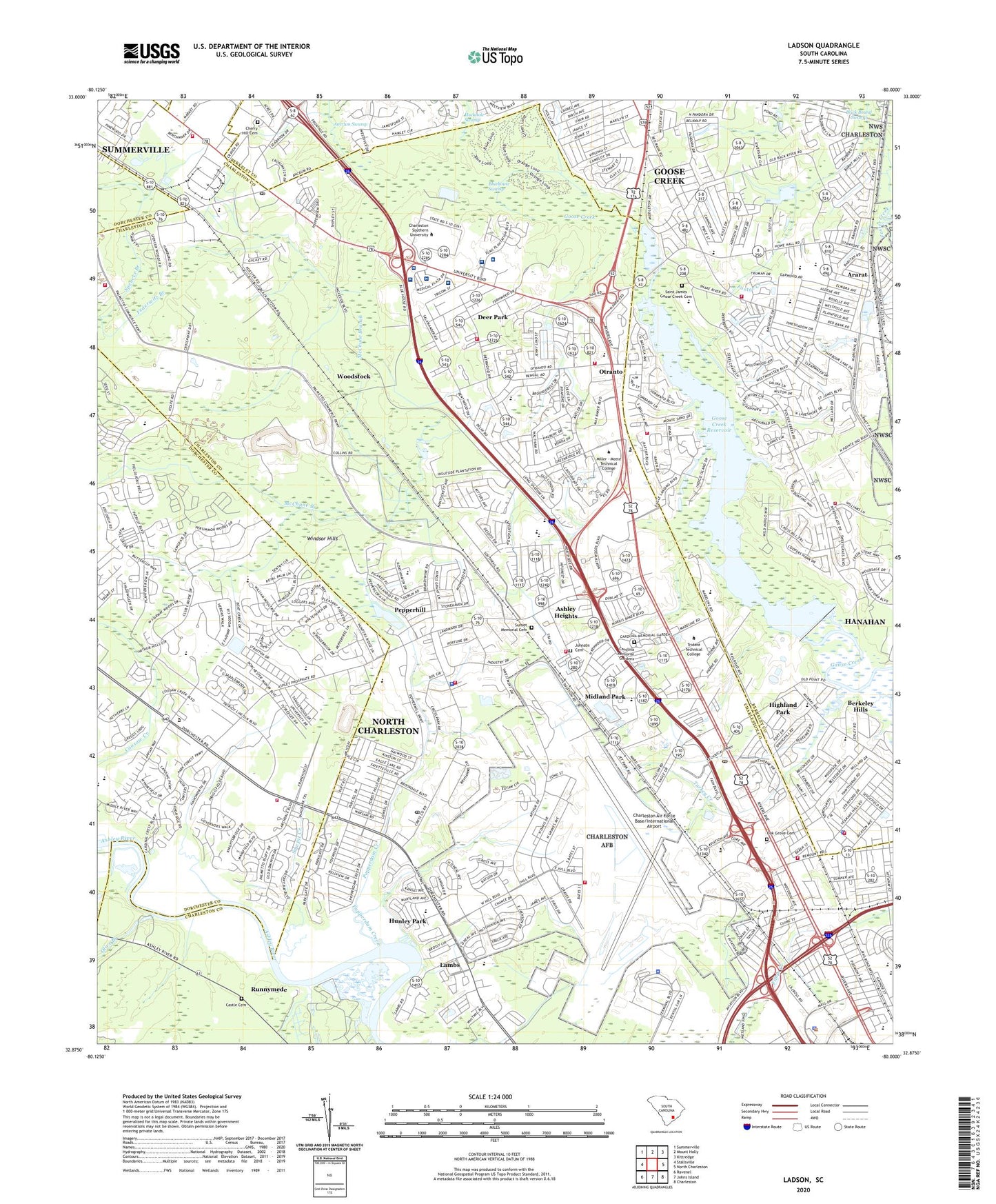
2024 topographic map quadrangle Ladson in the state of South Carolina. Scale: 1:24000. Based on the newly updated USGS 7.5' US Topo map series, this map is in the following counties: Charleston, Berkeley, Dorchester. The map contains contour data, water features, and other items you are used to seeing on USGS maps, but also has updated roads and other features. This is the next generation of topographic maps. Printed on high-quality waterproof paper with UV fade-resistant inks.
Quads adjacent to this one:
West: Stallsville
Northwest: Summerville
North: Mount Holly
Northeast: Kittredge
East: North Charleston
Southeast: Charleston
South: Johns Island
Southwest: Ravenel
This map covers the same area as the classic USGS quad with code o32080h1.
Contains the following named places: A C Corcoran Elementary School, Alice Birney Middle School, Ararat, Arch Dale Hall, Archdale, Ashley Heights, Ashley Industrial Park, Ashley Phosphate, Ashley Phosphate School, Aviation Square Shopping Center, Baptist College at Charleston, Belvedere, Benchmark Industrial Park, Berkeley County Library Hanahan Branch, Berkeley Hills, Bethune School, Bluehouse Swamp, Boykin Academy of Performing Arts, Bry Hawke Industrial Park, C and B Fire Department Company 2, Camelot Village, Carolina Memorial Gardens, Castle Cemetery, Cathedral Academy, Charles Towne Square Mall Shopping Center, Charleston Air Force Base, Charleston Air Force Base Fire Department, Charleston Air Force Base Post Office, Charleston Air Force Base/International Airport, Charleston Army Air Field, Charleston Aviation Authority Airport Police, Charleston County Public Library Otranto Road Regional Branch Library, Charleston Southern University, Charleston Southern University Bagwell - Settle Track, Charleston Southern University Brewer Center, Charleston Southern University C S Jones Hall, Charleston Southern University Derry Patterson School of Nursing, Charleston Southern University F K Norris Hall, Charleston Southern University H C Wing Hall, Charleston Southern University H E Ashby Hall, Charleston Southern University Hunter Reception Center, Charleston Southern University L Mendel Rivers Library, Charleston Southern University Learning Center, Charleston Southern University Lightsey Auditorium Lightsey Music Building, Charleston Southern University Littlejohn Parlor, Charleston Southern University Patsy Morley Pool, Charleston Southern University Russell East, Charleston Southern University Russell West, Charleston Southern University Science Building, Charleston Southern University Strom Thurmond Center, Charleston Southern University Whitfield Stadium Center, Charleston Southern University Whittington Hall, Charleston Surgery Center, Charleston Waterworks, Charlestone Academy, Cherry Hill Cemetery, City Colleges of Chicago, City of Goose Creek, City of Hanahan, City of North Charleston, City of North Charleston Headquarters, Coastal Shores Christian School, College Park Business Center, Colony North, Colony North Industrial Park, Cooper River Education Center, Cross County Post Office, Deer Park, Deerwood Heights, Diving Redeemer School, Dorchester County Lower Dorchester Wastewater Treatment Facility, Dorchester Industrial Center, Dorchester Manor, Eagle Landing Golf Club, Eagle Nest Elementary School, Elms Endoscopy Center, Embry - Riddle Aeronautical University, Federwitz Branch, Ferndale, Festival Center, Fishburne Elementary School, Forest Hills, Forestdale, Fort Dorchester High School, Gaslite Square Shopping Center, Goose Creek, Goose Creek Heights, Goose Creek High School, Goose Creek Post Office, Goose Creek Primary School, Goose Creek Reservoir, Goose Creek Rural Fire Department, Goose Plaza Shopping Center, Grace Christian Academy, Greg Mathis Charter High School, Hanahan, Hanahan Elementary School, Hanahan Fire Department Station 1, Hanahan Fire Department Station 2, Hanahan High School, Hanahan Police Department, Hanahan Senior Center, Harbour Lake, Healthsouth Rehabilitation Hospital of Charleston, Highland Park, Highland Terrace, Highlands, Hillsdale Park, Howe Hall Art Infused Magnet School, Howe Hall Plantation, Howe Hall School, Hunley Park, Hunley Park Elementary School, Johnson Cemetery, Ladson, Ladson Elementary School, Ladson Post Office, Ladson Station Industrial Park, Ladson Village, Lambs, Lambs Elementary School, Lambs School, Liberty Hill School, Liberty Hills, Liberty Mall Shopping Center, Liberty Park, Limestone College, Magnolia-on-the-Ashley, Maple Ridge, Matilda F Dunston Elementary School, McChune Branch, Menriv Park Elementary School, Midland Park, Midland Park Elementary School, Millbrook Plantation, Morningside Middle School, Norfolk Southern Corporate Police Department, North Charleston Air Force Station, North Charleston City Hall, North Charleston Division, North Charleston Fire Department Administration, North Charleston Fire Department Station 10, North Charleston Fire Department Station 12, North Charleston Fire Department Station 3, North Charleston Fire Department Station 4, North Charleston Fire Department Station 6, North Charleston Fire Department Station 8, North Charleston Fire Department Station 9, North Charleston Police Department, North Charleston Post Office, North Charleston Shopping Center, North Fiftytwo Square Shopping Center, North Pointe Plaza, North Rhett Industrial Park, Northrivers Market Shopping Center, Northside Christian School, Northwood Academy Lower School, Northwood Academy Upper School, Northwood Estates, Northwood Park Community Center, Northwoods Mall Shopping Center, Northwoods Merchant Plaza Shopping Center, Northwoods Point, Oak Grove, Oak Grove Cemetery, Oak Grove School, Oaks County Club, Olive Branch, Otranto, Otranto Plaza Shopping Center, Palmetto Commercial Center, Pepperdam Industrial Park, Pepperhill, Pepperhill Elementary School, Pepperhill Park Community Center, Pepperhill Square Shopping Center, Pepperidge, Pineview Hills, Pinewood Vista, Plantation Center Shopping Center, Pleasant Hills, Poppenheim Crossing, Popperdam Creek, R B Stall High School, Remount Road Elementary School, River Oaks Middle School, Riverbend, Riverbend Christian Academy, Runnymede, Runnymede Plantation, Russelldale, Russelldale Community Center, Saint James Estates, Saint James Goose Creek Cemetery, Sawpit Creek, Sedgefield, Sedgefield Intermediate School, Sedgefield Middle School, Shady Grove, Singing Pines, South Carolina Highway Patrol Troop 6 Post A, Southern Illinios University - Charleston Campus, Spencer Branch, Stratton Capers, Sunset Memorial Cemetery, Tenmile, The Farms, The Oaks, Trident Eye Surgery Center, Trident Medical Center, Trident Surgery Center, Trident Technical College, Turkey Creek, University Park, US Air Force Moral Welfare and Recreation Services Golf Course, US Drug Enforcement Agency, US Secret Service, Webster University, West Greenview Acres, Westview Primary School, Wildwood, Willowbrook, Wilsonville, Windsor Hill Elementary School, Windsor Hills, WKAO-AM (Hanahan), Woodstock, Yeaman Hall Plaza Shopping Center, ZIP Codes: 29404, 29406, 29410, 29418, 29420, 29423, 29456