MyTopo
Standingstone Mountain South Carolina US Topo Map
Couldn't load pickup availability
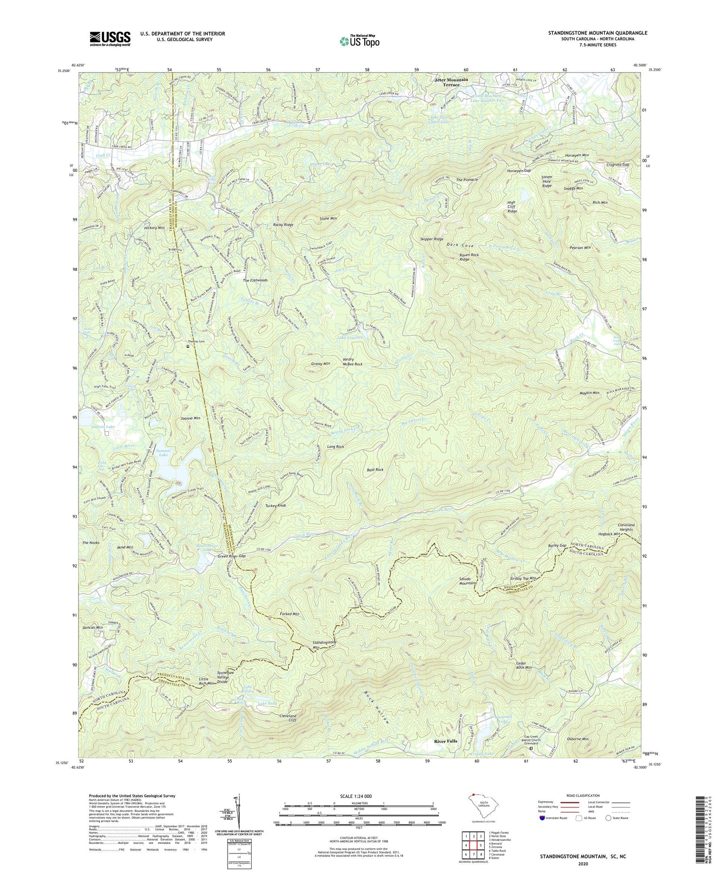
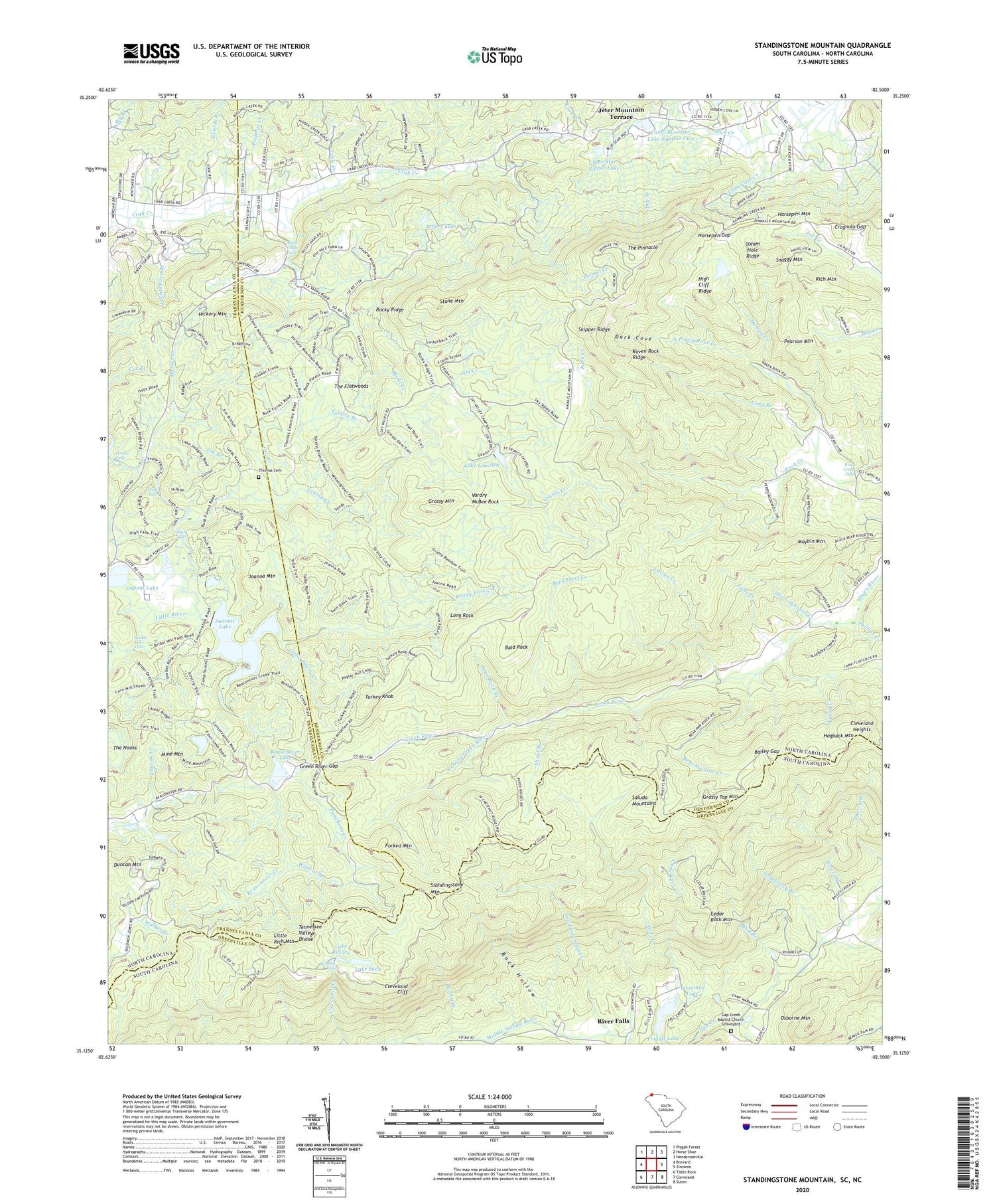
2020 topographic map quadrangle Standingstone Mountain in the states of North Carolina, South Carolina. Scale: 1:24000. Based on the newly updated USGS 7.5' US Topo map series, this map is in the following counties: Greenville, Henderson, Transylvania. The map contains contour data, water features, and other items you are used to seeing on USGS maps, but also has updated roads and other features. This is the next generation of topographic maps. Printed on high-quality waterproof paper with UV fade-resistant inks.
Quads adjacent to this one:
West: Brevard
Northwest: Pisgah Forest
North: Horse Shoe
Northeast: Hendersonville
East: Zirconia
Southeast: Slater
South: Cleveland
Southwest: Table Rock
Contains the following named places: Aaron Creek, Ailents Cove Branch, Bailey Gap, Bald Rock, Bear Wallow Creek, Big Laurel Creek, Blue Ridge Church, Blue Star Lower Dam, Blue Star Upper Dam, Blue Star Upper Lake, Bluff Branch, Bridal Veil Falls, Briery Fork Creek, Buck Hollow, Bullings Creek, Camp Blue Star, Camp Blue Star Lake Number Two, Camp Greenville, Cedar Rock Mountain, Cherry Branch, Cleveland Cliff, Cleveland Heights, Crab Creek Church, Cragnola Gap, Dark Cove, Dismal Creek, Dry Branch, Duncan Mountain, Dupont Dam, Dupont Lake, Falls Creek, Forked Mountain, Friddle Lake, Friendship Church, Gap Creek Baptist Church Graveyard, Gap Creek Church, Gap Creek School, Grassy Creek, Grassy Mountain, Grassy Top Mountain, Green River Gap, Hampy Creek, Head Foremost Creek, Hickory Mountain, Hide-A-Way Camp, High Cliff Ridge, High Falls, Hogback Mountain, Holly Springs Church, Holmes State Forest Nursery, Hooker Creek, Hooker Falls, Horsepen Gap, Horsepen Mountain, Jeffers Lake, Jeter Mountain Terrace, Jim Branch, Jim Creek, Joanna Mountain, Lake Louellen, Lake Rotary, Lake Sudy, Little Briery Creek, Little Cove Creek, Little Creek, Little Falls Creek, Little Rich Mountain, Long Branch, Long Rock, Long Rock Branch, Maybin Mountain, Meetinghouse Creek, Mine Mountain, North Prong Rock Creek, Osborne Mountain, Pearson Mountain, Peters Branch, Phillips Creek, Puncheon Creek, Rainbow Falls, Raven Rock Ridge, Reasonover Creek, Reasonover Lake, Reasonover Lake Dam, Rich Mountain, Rock Creek Falls, Rocky Branch, Rocky Ridge, Saint Francis by the Lake Chapel, Shoal Branch, Shoal Creek, Shoal Creek Falls, Skipper Ridge, Sky Valley Pioneer Camp, Snaggy Mountain, Socareda Camp, Solomon Chapel, South Carolina Noname 23019 D-2828 Dam, South Prong Green River, Standingstone Mountain, Steam Hole Ridge, Stone Mountain, Sudy Lake Dam D-2826, Summit Camp Lake, Summit Camp Lake Lower Dam, Summit Camp Lake Upper Dam, Summit Lake, Swords Branch, Symmes Chapel, Tankersley Branch, Tarkiln Branch, The Flatwoods, The Nooks, The Pinnacle, Thomas Cemetery, Trammell Lake, Triple Falls, Turkey Knob, Uncles Creek, Valley Hill Fire and Rescue Station 2, Vardry McBee Rock, Wabak Camp, WESC-FM (Greenville), Wildcat Branch, ZIP Codes: 28790, 29661