MyTopo
Hendersonville North Carolina US Topo Map
Couldn't load pickup availability
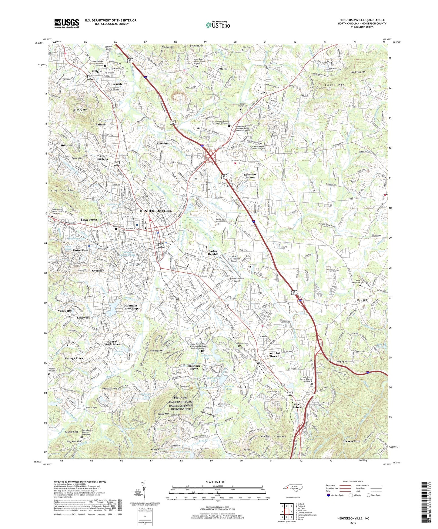
2022 topographic map quadrangle Hendersonville in the state of North Carolina. Scale: 1:24000. Based on the newly updated USGS 7.5' US Topo map series, this map is in the following counties: Henderson. The map contains contour data, water features, and other items you are used to seeing on USGS maps, but also has updated roads and other features. This is the next generation of topographic maps. Printed on high-quality waterproof paper with UV fade-resistant inks.
Quads adjacent to this one:
West: Horse Shoe
Northwest: Skyland
North: Fruitland
Northeast: Bat Cave
East: Cliffield Mountain
South: Zirconia
This map covers the same area as the classic USGS quad with code o35082c4.
Contains the following named places: Allen Branch, Atha Plaza, Atkinson Elementary School, Balfour, Balfour Census Designated Place, Balfour School, Barker Heights, Barker Heights Census Designated Place, Bat Fork, Beaumont, Beck Creek, Bent Tree, Berea Baptist Church Graveyard, Berkeley Ball Park, Blue Ridge Community College (Flat Rock Campus), Blue Ridge Mall, Bonclarken Assembly Grounds, Bonclarken Lake, Bonclarken Lake Dam, Brittain Creek, Brookdale, Brookland Manor, Bryson Mountain, Buckeye Ford, Butt Mountain, Cagle Mountain, Camarian Estates, Camp Pinewood, Camp Pinnacle, Camp Tonawandah, Cannon Woods, Capps Branch, Carl Sandburg Home National Historic Site, Carolina Village, Chamber of Commerce, Chanteloupe Country Estates, Cherry Branch, Cinnimon Woods, City of Hendersonville, Claremont, Clear Creek, Country Acres, Country Club Estates, County School Administration, Crooked Creek, Crooked Creek Dam, Crooked Creek Lake, Cross William MHP, Crystal Spring, Cumberland Village, Dana, Dana Fire and Rescue Department, Dana Post Office, Dellwood, Devils Fork, Dodging Hill, Druid Hills, Dunn Creek, East Flat Rock, East Flat Rock Census Designated Place, East Flat Rock Elementary School, East Flat Rock Post Office, East Henderson High School, Ebenezer Baptist Church Graveyard, Echo Acres, Echo Lakes, English Hills, Essex, Fair Haven Baptist Church Graveyard, Faith Christian Day School, Featherstone Creek, Finley Creek, Five Points, Flat Rock, Flat Rock Forest, Flat Rock Junior High School, Flat Rock Playhouse, Flat Rock Post Office, Forest Lawn Memorial Park, Four Season Mall, Four Square Crusador Camp, Front Lake, Front Lake Dam, Glassy Mountain, Glenn Brook, Greer Creek, Grimesdale, Guice Mountain, Henderson County, Henderson County Building, Henderson Mountain, Hendersonville, Hendersonville Airport, Hendersonville Annex Post Office, Hendersonville Elementary School, Hendersonville Fire Department Station 1, Hendersonville Fireman Training Center, Hendersonville Golf and Country Club, Hendersonville High School, Hendersonville Junior High School, Hendersonville Post Office, Hendersonville Quarry, Heritage Square Village Mall, Hertiage Hall School, Hickory Hill, Highland Hills, Highland Lake, Hill Branch, Hillandale, Hillandale School, Hillgirt, Holly Hill, Immaculata Catholic School, Indian Hills, Johnson Bridge, Johnson Ditch, Jones Branch, Jones Family Cemetery, Jordans Lake, Kanuga Pines, Kenmure Pond, Kenmure Pond Dam, Kenwood Knolls, King Creek, King Mountain, Kingswood, Lake Curtis, Lake Falls, Lakeview Estates, Lakewood, Laurel Branch, Laurel Creek, Laurel Park, Laurel Park Lake, Laurel Park Lake Dam, Laurel Park Villas, Laurel Rock Acres, Little Mud Creek, Long John Mountain, Love Cemetery, Lugana Lake, McCabe Pond, Meminger Creek, Mine Gap, Moores Grove United Methodist Church Graveyard, Mount Zion Baptist Church Graveyard, Mountain Home, Mountain Home Fire and Rescue Department Station 1, Mountain Home Fire and Rescue Department Station 2, Mountain Home Post Office, Mountain Lake Camp, Mud Creek Assembly Grounds, Murray Creek, Oak Grove Baptist Church Graveyard, Oak Hill, Oakdale Cemetery, Osceola Lake, Osceola Lake Dam, Our Lady of the Hills Camp, Overlook, Pardee Hospital, Park, Patton Park, Pebble Creek, Perry Creek, Phillips Branch, Pine Park Retirement Inn, Pinehurst, Plantation Walk, Play Rock Hill, Pleasant Hill Cemetery, Quail Ridge, Quilt Creek, Railpen Gap, Rainbow Lake, Ravenwood, Rhett Mill Dam, Ridgeview Estates, Rosebud, Rutledge Mountain, Saint John In The Wilderness Episcopal Church Graveyard, Saint Matthews Episcopal Church Graveyard, School City Administration, Seagle Drake Cemetery, Sentell Knob, Shaws Creek Baptist Church Graveyard, Shepherd Creek, Side Lake, Side Lake Dam, Smyth Station, Stone Brook, Stoney Mountain, Stoney Mountain Estate, Stoney Mountain Rest Home, Stoneycrest, Temple Terrace Lake, Teneriffe, Teneriffe Mountain, Terrace Gardens, The Meadows, The Pines, Timberland, Ton-A-Wanda Dam, Tonys Creek, Town Forest, Township of Hendersonville, Tracy Grove Community Center, Tranquility, Twin Bridges, U-No, Upward, Valley Hill, Valley Hill Census Designated Place, Valley Hill Fire and Rescue Headquarters, Village of Flat Rock, W N C Air Museum Airport, Wash Creek, Western North Carolina Fairgrounds, Westwood, WHKP-AM (Hendersonville), WHVL-AM (Hendersonville), Willow Bend, Willow Brook, Willow Wew, Windor Hills, WKIT-FM (Hendersonville), Wolf Lake, Wolf Lake Dam, Wolfpen Creek, Woodhaven, Woodland Trace, World of Clothing, YMCA, ZIP Codes: 28726, 28731