
MyTopo
Sumter West South Carolina US Topo Map
Couldn't load pickup availability
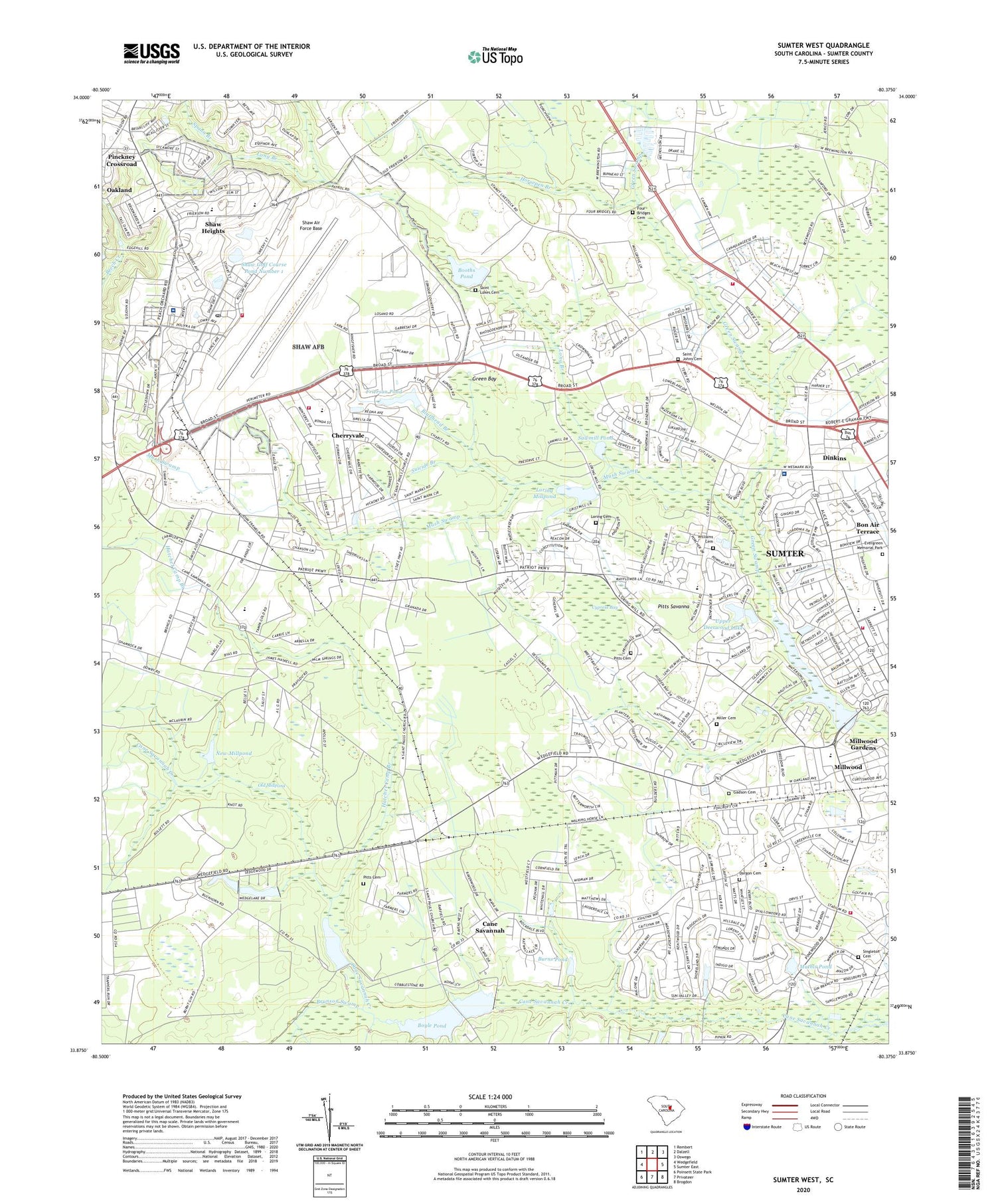
2020 topographic map quadrangle Sumter West in the state of South Carolina. Scale: 1:24000. Based on the newly updated USGS 7.5' US Topo map series, this map is in the following counties: Sumter. The map contains contour data, water features, and other items you are used to seeing on USGS maps, but also has updated roads and other features. This is the next generation of topographic maps. Printed on high-quality waterproof paper with UV fade-resistant inks.
Quads adjacent to this one:
West: Wedgefield
Northwest: Rembert
North: Dalzell
Northeast: Oswego
East: Sumter East
Southeast: Brogdon
South: Privateer
Southwest: Poinsett State Park
Contains the following named places: Alice Drive Elementary School, Alice Drive Junior High School, Allen Chapel, Ashley Creek Village, Audubon Park, Austin Acres, Avondale, Azalea Trailer Park, Bay Springs, Beckridge Park, Beckwood, Bluffhead Branch, Bold Pilgrim Church, Bon Air Terrace, Booths Pond, Booths Pond Dam D-1985, Boyle Pond, Boyle Pond Dam D-1583, Bradford, Brunson Swamp, Burns Pond, Burns Pond Dam D-2056, Cane Savannah, Cane Savannah Census Designated Place, Cane Savannah Raceway, Carolina Mobile Home Park, Catchall Spann School, Causeway Branch, Chapel Number 2, Cherryvale, Cherryvale Census Designated Place, Cherryvale School, City of Sumter, Creech Aviation Facility Airport, Curtis Park, Cypress Bay, Dargon Cemetery, Deerfield, Dinkins, East Sunway Knolls, Edgewater, Evergreen Memorial Park, Four Bridges Cemetery, Four Bridges Church, Four Bridges School, Frierson Pond, Gadson Cemetery, Gamecock Raceway, General Sumter Estates, Green Bay, Green Park, Green School, Hatchet Camp Branch, Hearthstone, Heathley Wood, High Hills Middle School, Hilldale, Home Acres, Horsepen Branch, Idlewood, Jordan School, Lake Cherryvale Dam D-1986, Long Branch, Long Branch Church, Loring Cemetery, Loring Millpond, Loring Millpond Dam D-1452, Lower Deerwood Lake, Lower Deerwood Lake Dam D-2078, Marden Ranchettes, Mathis Pond, Mathis Pond Dam D-2057, McCray Lake, McCray Lake Dam D-1584, Memorial Stadium, Miller Cemetery, Millwood, Millwood Census Designated Place, Millwood Elementary School, Millwood Gardens, Montagues Pond Dam D-2055, Mount Vernon School, Mount Zion Church, Mush Swamp, Nasty Branch, New Millpond, North Deerfield, Oak Haven Acres, Oakland, Oakland Census Designated Place, Oakland Elementary School, Oakland Plantation, Old Millpond, Palmetto Park, Park West, Pinckney Crossroad, Pine Hill Church, Pine Hill School, Pitts Cemetery, Pitts Savanna, Rainbow Falls, Reese Chapel, Saint James Church, Saint John Church, Saint Johns Cemetery, Saint Luke School, Saint Lukes Cemetery, Saint Lukes Church, Saint Michaels School, Saint Paul Lutheran Church, Savannah Plaza Shopping Center, Sawmill Pond, Sawmill Pond Dam D-1987, Second Millpond, Second Millpond Dam D-1444, Sellars Heights, Shady Grove, Shaw Air Force Base, Shaw Air Force Base Fire Department, Shaw Golf Course Pond Number 1, Shaw Heights, Shaw Heights Elementary School, Singleton Cemetery, Spann Branch, Spring Lake, Suicide Branch, Summer View, Sumter County, Sumter County Career Center, Sumter Fire Department Alice Drive Station, Sumter Fire Department Cherryvale Station 1, Sumter Fire Department Stadium Road Station, Sumter Fire Department Thomas Sumter Station, Sumter High School, Sunset Country Club, Sunset Homes, Sunway Knolls, Swinton, Twin Lakes, United States Air Force Clinic Shaw, Upper Deerwood Lake, Upper Deerwood Lake Dam, Warwick Estates, Wedgewood Grove, Wesmark Ambulatory Surgery Center, West Lake, West Lake Dam D-2054, West Ridge, Westhaven, Westmark Plaza Shopping Center, Williams Cemetery, Wilson Hall School, Windsor City Mobile Home Park, Winter Park, Woodland Church of Christ, ZIP Codes: 29152, 29154


