
MyTopo
Taylors South Carolina US Topo Map
Couldn't load pickup availability
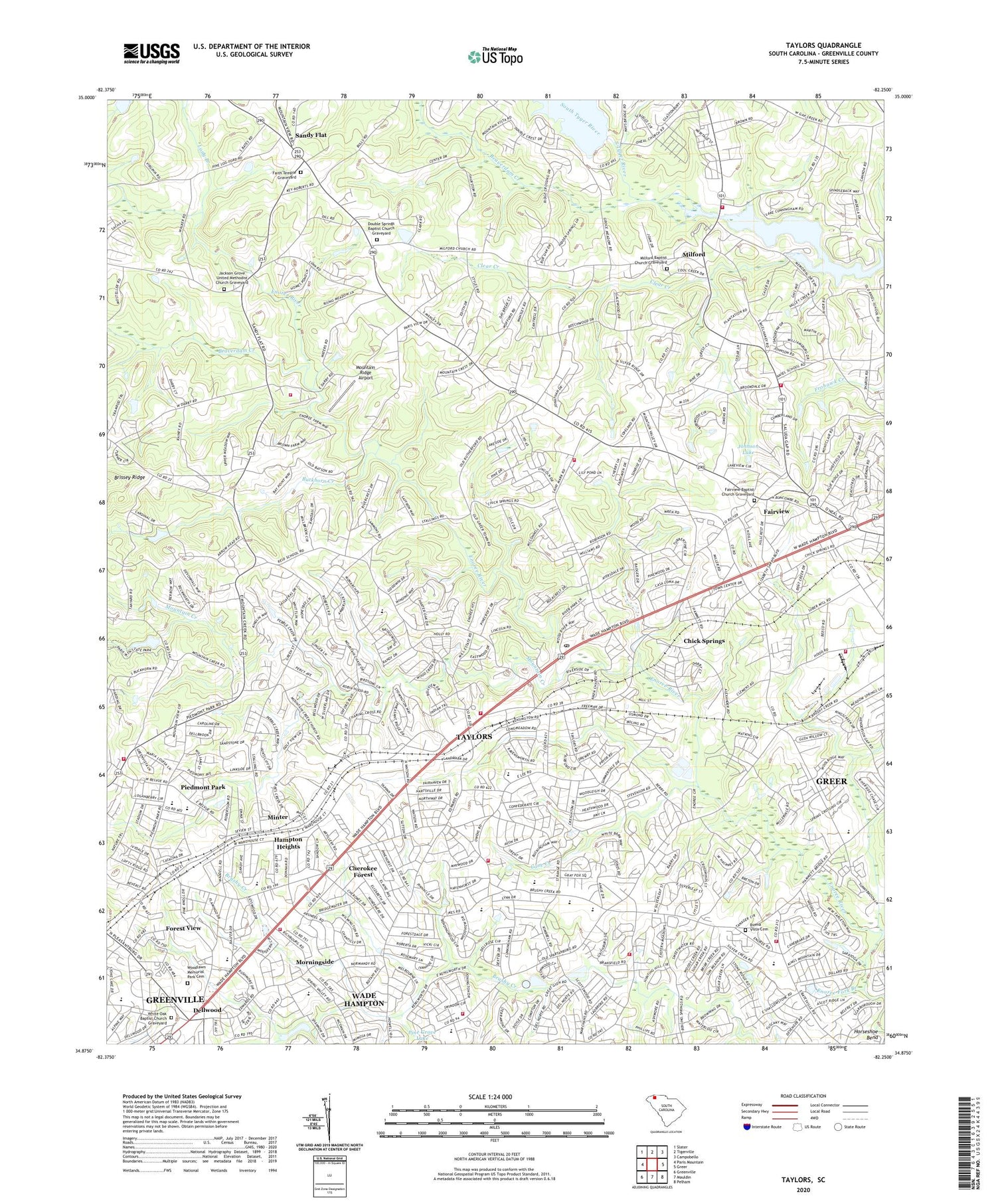
2020 topographic map quadrangle Taylors in the state of South Carolina. Scale: 1:24000. Based on the newly updated USGS 7.5' US Topo map series, this map is in the following counties: Greenville. The map contains contour data, water features, and other items you are used to seeing on USGS maps, but also has updated roads and other features. This is the next generation of topographic maps. Printed on high-quality waterproof paper with UV fade-resistant inks.
Quads adjacent to this one:
West: Paris Mountain
Northwest: Slater
North: Tigerville
Northeast: Campobello
East: Greer
Southeast: Pelham
South: Mauldin
Southwest: Greenville
Contains the following named places: Aikens Chapel, Aldersgate Church, Ansel School, Batson Pond, Batson Pond Dam D-2869, Beaverdam Creek, Bellwood Estates, Belmont Heights, Bethel Church, Bird Fields, Boiling Springs Fire District Station 2, Boiling Springs Fire District Station 3, Botany Woods, Boulevard Church, Broadleaf Acres, Broadmoor, Brook Glenn Elementary School, Brookwood Forest, Brown School, Brushy Creek Church, Brushy Creek School, Buckhorn Creek, Buena Vista Cemetery, Buena Vista Elementary School, Burgiss Hills, Campmeeting Tabernacle, Cane Brake, Cane Creek, Cannon Hills, Cardinal Lake, Cardinal Lake Dam D-2871, Carolina Golf and Tennis Club, Cherokee Forest, Chick Springs, Christian Fellowship Church, Clear Creek, Colonial Hills, Colonial Hills Christian School, Creekside Villas, Crossroads School, Cunningham Acres, Del Norte, Del Norte Estates, Dell Vista Heights, Dellwood, Double Springs Baptist Church Graveyard, Double Springs Church, East Gate Village, East North Street Church, East Riverside Park, Eastgate Shopping Center, Eastside Church, Eastside High School, Edwards Forest Heights, Edwards Road Church, Emmanuel Church, Enoree Fork Baptist Church, Enoree Fork Branch, Enoree Hills, Fairview, Fairview Baptist Church, Fairview Baptist Church Graveyard, Fairview Church, Fairview Elementary School, Fairview School, Faith Temple, Faith Temple Graveyard, Fellowship Church, Foothills Vocational Center, Forest View, Forestdale Heights, Fork School, Franciscan Monastery, Gilreaths Mill, Gilstrap Heights, Grace Church, Green Forest, Green Hills, Greenville County, Greer Fire Department Station 2, Grey Fox Run, Groveland Church, Groveland Dell, Hampton Heights, Hampton Heights Church, Hampton High School, Hermitage Hills, Homestead Acres, Jackson Grove Church, Jackson Grove United Methodist Church Graveyard, Jamestown Estates, Johnson Lake, Jubilee Church, King Acres, Kings, Kingsgate, Lake Cunningham, Lake Cunningham Fire Department Station 1, Lake Cunningham Fire Department Substation, Lake Forest Elementary School, Lake Forest Shopping Center, Lake Placid, Lake Placid Dam D-1399, Laurel Hills, League Middle School, Lee Road Church, Liberty Park, Lincoln School, Long Branch, Lorena Park, McSwain Gardens, Milford, Milford Baptist Church Graveyard, Milford Church, Minter, Mitchell Road Elementary School, Morningside, Mount Vernon Estates, Mount View Church, Mountain Creek, Mountain Creek Church, Mountain Ridge Airport, North Acres, North Side Heights, Northside PArk, Northwood, Northwood Middle School, Nursery, Oak Hollow, Oak View, Old Mill Estates, O'Neal Church, O'Neal School, Orchard Acres, Paris, Paris Elementary School, Peachtree Shopping Center, Pebble Creek, Pebble Creek Church, Pebble Creek Golf Course, Peppertree, Piedmont Park, Piedmont Park Fire Department, Piedmont Park Fire Department Headquarters, Piedmont Plaza Shopping Center, Pine Knott Forest, Pinehaven Acres, Pinewood Estates, Piney Ridge, Pleasant View Church, Reid School, Riverdowns, Riverside High School, Rock Hill Church, Rosedale, Rutherford Road Church, Saint Francis Church, Saint Luke Church, Saint Marks Church, Saint Matthews Church, Sandy Flat, Seven Oaks, Sevier Middle School, Shady Creek, Shriners Hospital, Silver Leaf, South Carolina Noname 23002 Dam, Southern Bleachery Church, Southern Worsted Tabernacle, Spring Forest, Stephenson Memorial Church, Stone Lake Heights, Storalls Mill, Suber, Sugar Creek, Sugar Creek Villas, Sugar Mill, Sylvan Hills, Taylors, Taylors Census Designated Place, Taylors Division, Taylors Elementary School, Taylors Fire Department Station 1, Taylors Fire Department Station 2, Taylors Fire Department Station 3, Taylors Post Office, The Meadows, Thornwood, Thornwood Acres, Trinity Bible Church, Trinity Temple, United States Public Health Service Hospital, Valley Haven, Wade Hampton, Wade Hampton Census Designated Place, Wade Hampton Elementary School, Wade Hampton Fire Department Station 1, Wade Hampton Fire Department Station 3, Wade Hampton Gardens, Wade Hampton Plaza Shopping Center, Wade Hampton Village Shopping Center, Walden Pond, Washington Baptist Church, WCKI-AM (Greer), White Oak, White Oak Baptist Church Graveyard, White Oak Church, Wildaire, Willington Green, Willow Heights, Windsor Oaks, WMUU-AM (Greenville), Woodlawn Memorial Park Cemetery, ZIP Codes: 29650, 29687


