MyTopo
Wellford South Carolina US Topo Map
Couldn't load pickup availability
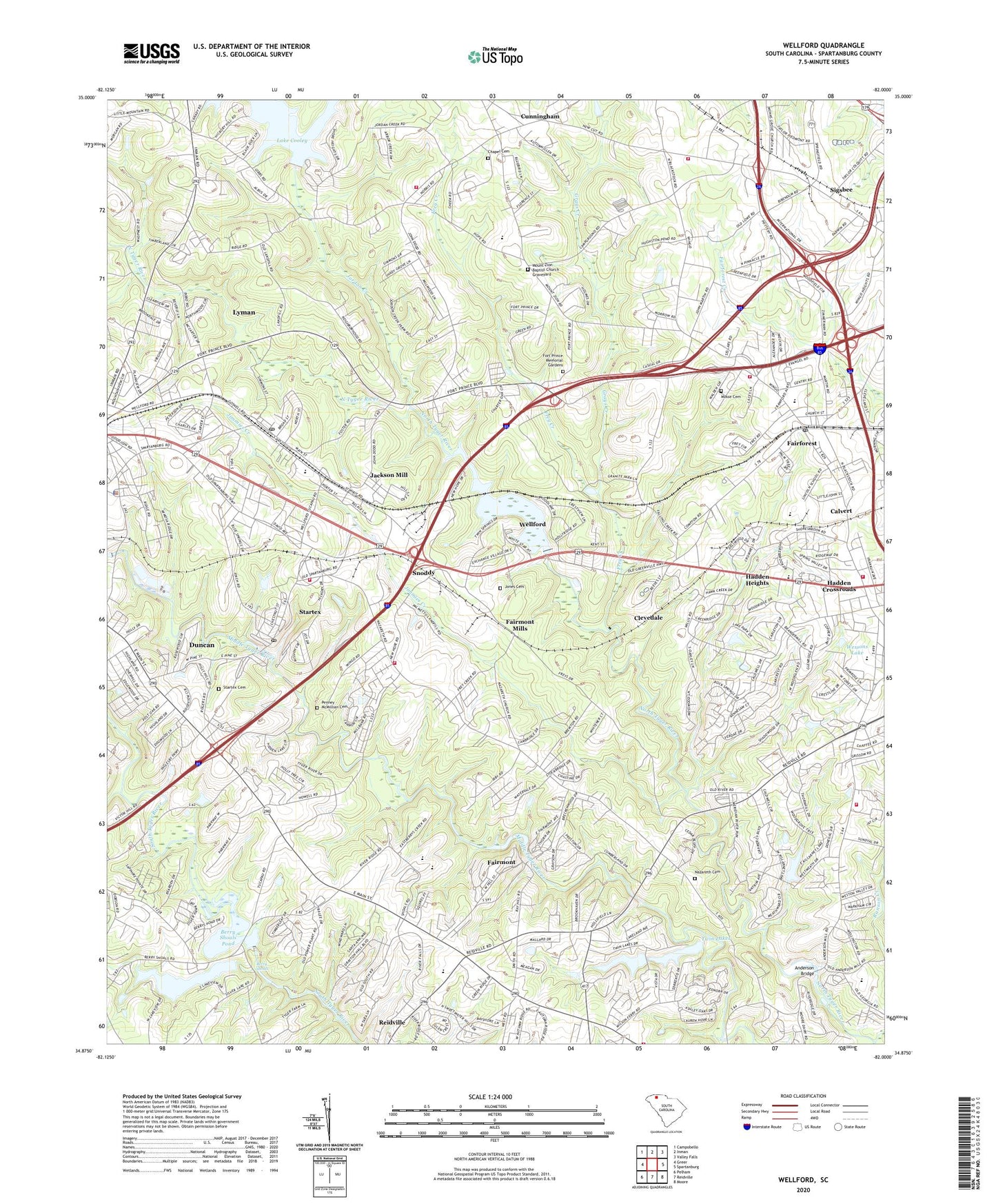
2020 topographic map quadrangle Wellford in the state of South Carolina. Scale: 1:24000. Based on the newly updated USGS 7.5' US Topo map series, this map is in the following counties: Spartanburg. The map contains contour data, water features, and other items you are used to seeing on USGS maps, but also has updated roads and other features. This is the next generation of topographic maps. Printed on high-quality waterproof paper with UV fade-resistant inks.
Quads adjacent to this one:
West: Greer
Northwest: Campobello
North: Inman
Northeast: Valley Falls
East: Spartanburg
Southeast: Moore
South: Reidville
Southwest: Pelham
Contains the following named places: Anderson Bridge, Ashley, Berry Shoals, Berry Shoals Pond, Berry Shoals Pond Dam D-3345, Bethel Church, Brookhaven, Brookside Village, Buckeye Forest Church, Calvert, Cambridge, Chapel Cemetery, Chappel High School, City of Wellford, Clevedale, Cold Spring, Country Corners Shopping Center, Cunningham, Cunningham School, Duncan Fire Department Station 2, E Cauldwell Pond Dam D-3353, Fairforest, Fairforest Baptist Church Graveyard, Fairforest Census Designated Place, Fairforest Elementary School, Fairforest Middle School, Fairmont, Fairmont Church, Fairmont Mills, Fairmont Mills Division, Fairview School, Fellowship Church, First Baptist Church of Fairforest Graveyard, Florence Chapel, Forest Park, Fort Prince Farms, Fort Prince Memorial Gardens, Foster Cemetery, Fountain of Life Baptist Church Graveyard, Fox Hunt, Franklin Village, Frey Creek, Friers Chapel, Friers School, Gary Creek, Good Shepherds Fellowship Church, Grays Creek, Greenridge, Hadden Crossroads, Hadden Heights, Holly Tree, Hopewell Church, Hub City Church Cemetery, Immanuel Church, Jackson Mill, Jimmies Creek, Jones Cemetery, Jordan Creek, Lake Ridge, Larkin, Lincoln Middle School, Loree Church, Lyman Elementary School, Lyman Police Department, McElrath Family Cemetery, Monks Grove Baptist Church, Monks Grove School, Moore Memorial Church, Mosse Cemetery, Mount Zion, Mount Zion Baptist Church, Mount Zion Baptist Church Graveyard, Mount Zion Church, Nazareth Cemetery, Nazareth Presbyterian Church, New Faith Baptist Church Graveyard, New Trinity Baptist Church Graveyard, New Trinity Church, North Spartanburg Fire Department Station 2, North Spartanburg Fire Department Station 3, Northwest Community Church, Oak Grove Church, Palmetto West Mobile Home Park, Penney - McMillian Cemetery, Perkins Memorial Cemetery, Pine Grove, Pinebrook, Piney Hill School, Pinnacle Heights, Poplar Springs Fire Department Station 2, River Edge, Shady Grove School, Shores Brook Lake, Shoresbrook, Shoresbrook Golf Club, Sigsbee, Silver Lake, Snoddy, South Carolina Noname 42002 D-3346 Dam, South Carolina Noname 42015 D-3347 Dam, South Carolina Noname 42016 D-3348 Dam, South Carolina Noname 42019 D-3354 Dam, Startex, Startex Cemetery, Startex Census Designated Place, Startex Elementary School, Startex Fire Department, Startex Mill Pond Number One Dam D-3342, Tanners Mill, Town of Lyman, Travelers Rest Church, Twin Lakes, Union School, Upper Shady Grove Baptist Church Graveyard, Upper Shady Grove Church, Valley Dale Park, Water Oaks, Wayside Christian School, Wellford, Wellford Cemetery, Wellford Elementary School, Wellford Estates, Wellford Intermediate School, Wellford Police Department, Wellford Primary School, Wellford Rescue Squad, Wellford School, Wellington West, Wesley Chapel, Wessons Lake, West Forest, West View Elementary School, Westhaven, Westview - Fairforest Fire Department Station 2, Westview Fairforest Fire Station 1, Westview Fairforest Fire Station 3, Westview Heights, Westwood Memorial Gardens Cemetery, Wingo Heights Church, Woodfield, ZIP Codes: 29301, 29334, 29377, 29385