MyTopo
Moore South Carolina US Topo Map
Couldn't load pickup availability
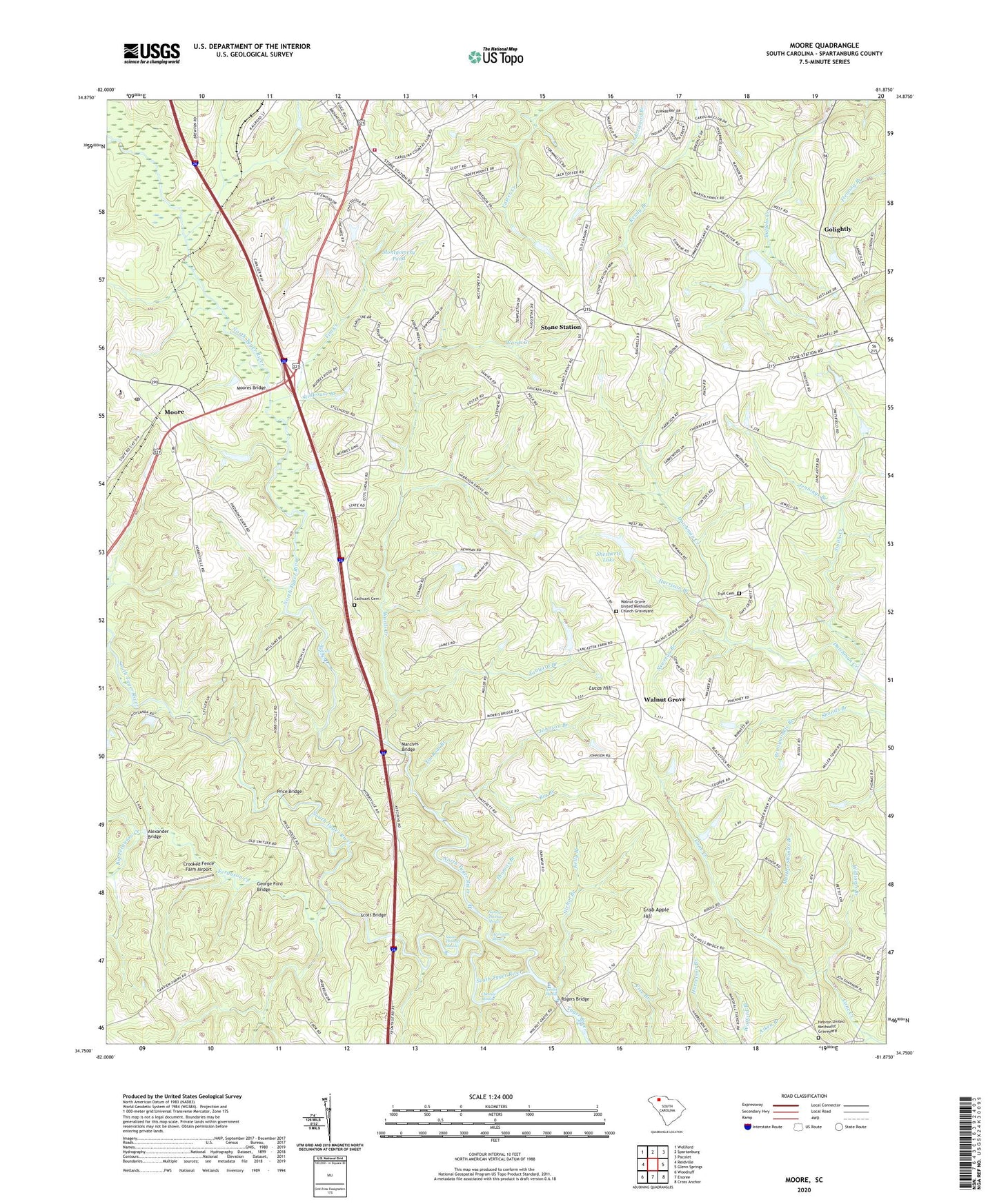
2024 topographic map quadrangle Moore in the state of South Carolina. Scale: 1:24000. Based on the newly updated USGS 7.5' US Topo map series, this map is in the following counties: Spartanburg. The map contains contour data, water features, and other items you are used to seeing on USGS maps, but also has updated roads and other features. This is the next generation of topographic maps. Printed on high-quality waterproof paper with UV fade-resistant inks.
Quads adjacent to this one:
West: Reidville
Northwest: Wellford
North: Spartanburg
Northeast: Pacolet
East: Glenn Springs
Southeast: Cross Anchor
South: Enoree
Southwest: Woodruff
This map covers the same area as the classic USGS quad with code o34081g8.
Contains the following named places: Alexander Bridge, Big Branch, Big Ferguson Creek, Cathcart Cemetery, Center Point Baptist Church Graveyard, Chesnee Shoals, Crab Apple Hill, Crooked Fence Farm Airport, Ferguson Creek, Foster Chapel Baptist Church, Foster Chapel Baptist Church Cemetery, Foster School, Gatewood, George Ford Bridge, Golightly, Golightly Church, Golightly Harris Cemetery, Golightly School, Golightly United Methodist Church, Harrison Branch, Harrison Grove Baptist Church, Harrison Grove School, Harrison Shoals, Hebron United Methodist Church, Hebron United Methodist Graveyard, Holiness Church, Jennings Branch, Johnson Branch, Kelly Branch, L E Gable Middle School, Little Ferguson Creek, Lucas Hill, Marches Bridge, Martha Shands Branch, Middle Tyger River, Millville, Montgomery Pond, Moore, Moore Church, Moore School, Moores Bridge, Moores Chapel Baptist Church Cemetery, Mount Calvary Presbyterian Church, Mount Calvary Presbyterian Church Graveyard, Nancy Thomas Shoals, Nesbit Shoals, Nesbitt School, Nesbitts Bridge, Newman Branch, Nichol Branch, North Tyger River, Old Golightly Mill, Ott Shoals, Pauline Division, Pennywinkle Branch, Pine Grove School, Price Bridge, Price Historical House, Prices Post Office, R P Anderson Area Vocational Center, Riverside School, Roebuck Fire Department Station 1, Roebuck Primary School, Rogers Bridge, Scott Bridge, Sherberts Lake, Smith Creek, Smiths Tavern, South Carolina Noname 42009 D-3357 Dam, South Carolina Noname 42021 D-3358 Dam, South Tyger River, Spartanburg County Cemetery, Stillhouse Branch, Stone Station, Stone Station Church, Susan Thomas Shoals, Switzer Church, Switzer Church of God Graveyard, Tanyard Branch, Thomas Branch, Tim Creek, Tin Roof Branch, Trail Cemetery, Underwood School, Walnut Grove, Walnut Grove Plantation, Walnut Grove School, Walnut Grove United Methodist Church, Walnut Grove United Methodist Church Graveyard, Wards Creek, Williams Branch, Wofford Chapel, Zimmerman Pond, ZIP Code: 29376