MyTopo
Bellevue Tennessee US Topo Map
Couldn't load pickup availability
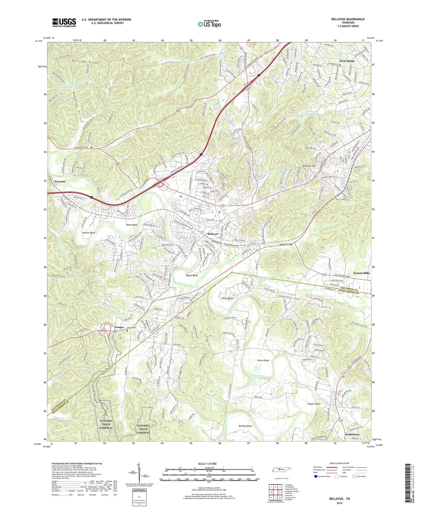
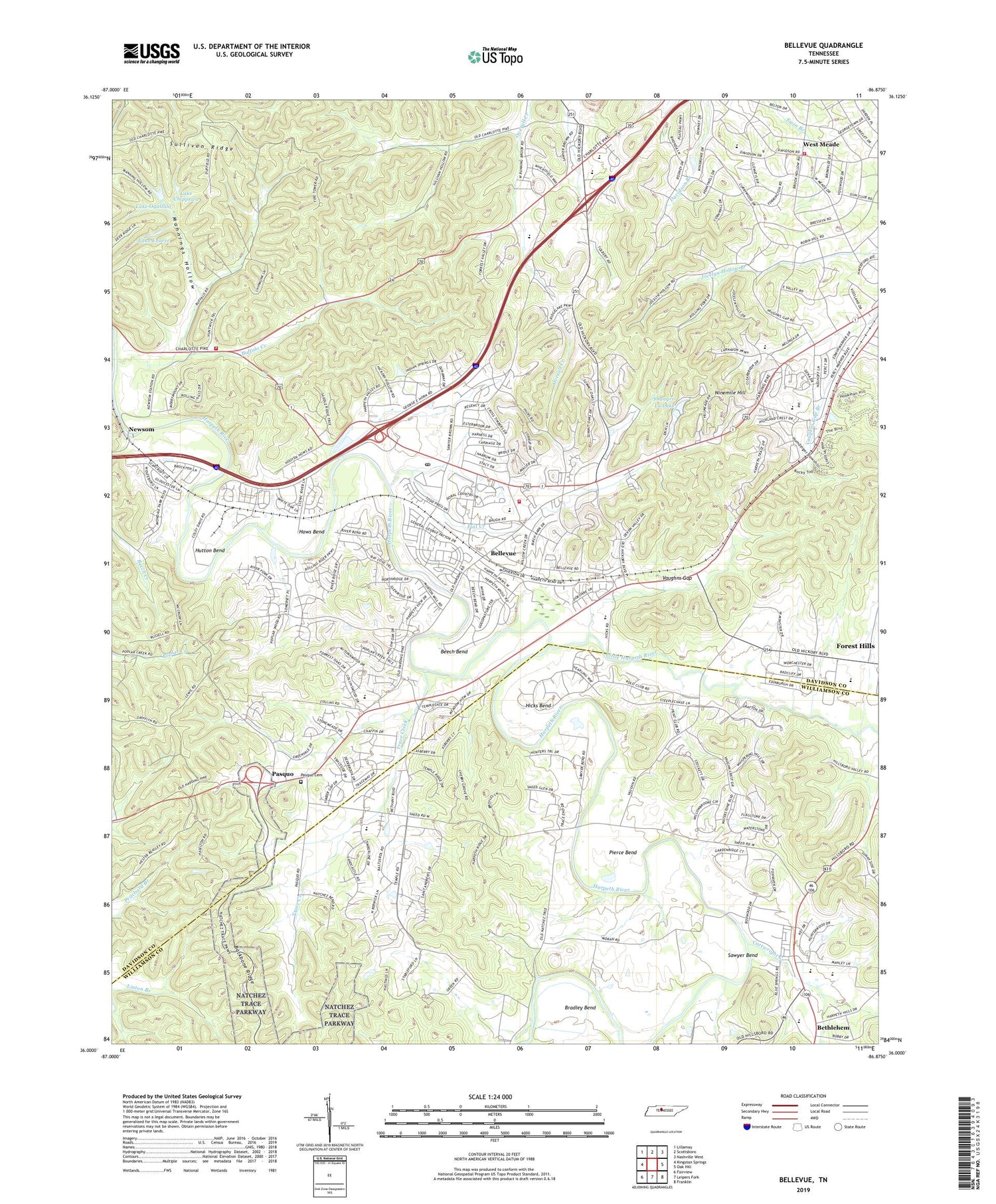
2019 topographic map quadrangle Bellevue in the state of Tennessee. Scale: 1:24000. Based on the newly updated USGS 7.5' US Topo map series, this map is in the following counties: Davidson, Williamson. The map contains contour data, water features, and other items you are used to seeing on USGS maps, but also has updated roads and other features. This is the next generation of topographic maps. Printed on high-quality waterproof paper with UV fade-resistant inks.
Quads adjacent to this one:
West: Kingston Springs
Northwest: Lillamay
North: Scottsboro
Northeast: Nashville West
East: Oak Hill
Southeast: Franklin
South: Leipers Fork
Southwest: Fairview
Contains the following named places: Apostolic Christian Church, Ash Grove Church, Ash Grove School, Beech Bend, Belle Forest Shopping Center, Bellevue, Bellevue Branch Nashville and Davidson Public Library, Bellevue Christian Church, Bellevue Church of Christ, Bellevue Elementary School, Bellevue High School, Bellevue Mall Shopping Center, Bellevue Middle School, Bellevue Park, Bellevue Post Office, Bellevue Shopping Center, Bellevue United Methodist Church, Bellevue Village Shopping Center, Bellevue West Shopping Center, Bethany Hills, Bethlehem, Bethlehem United Methodist Church, Brook Hollow Church, Brookmeade Church, Browns School, Buffalo Creek, Buffalo School, Cambron Field, Cartwright Creek, Cedar Tree Day Camp of Agape Fellowship Church, Centenary Church, Central Zion Church, Charlotte Road Baptist Church, Charlotte Shopping Center, Christ Presbyterian Academy, Christ Presbyterian Church, Coleman Brown School, Commissioner District 22, Commissioner District 23, Commissioner District 35, Cornerstone Church, DeMoss Mill, Devonshire Manor, Dunkled Estates, Edneys Meeting House, Edwin Warner Park, Flat Creek, Gospel Chapel, Gower School, Grassland Elementary School, Grassland Estates, Grassland Middle School, Greater Nashville Unitarian Universalist Congregation, Greater Pleasant View Church, Harpeth Estates, Harpeth Heights Church, Harpeth River Estates, Harpeth River Park, Harpeth Valley School, Hicks Bend, Hill School, Hillsboro Valley, Hillview Church, Hillwood Church, Hows Bend, Hunters Hill, Hunters Ridge, Hutton Bend, Iroquois Meadows, Kingdom Hall of Jehovahs Witnesses of Bellevue, Lake Chippewa, Lake Enoree, Lake Ogallala, Lake Ogallala Dam, Little Harpeth River, Little Zion Church, Longwood, Madison Christian Church, Mannings Hollow, Nashville Christian School, Nashville Fire Department Station 34, Nashville Fire Department Station 37, Nashville Fire Department Station 7, Natchez Hills Estate, New Beginnings Church, Newsom, Newsom School, Newsoms Mill, Newsoms Station, Ninemile Hill, Oasis Church, Old Hickory Boulevard Church of Christ, Old Stone Church, Pasquo, Pasquo Cemetery, Pasquo Church of Christ, Pasquo School, Percy Warner Park, Pickens Acres, Pierce Bend, Poplar Hills, Praise God Ministries, Red Bud, River Rest, River Road Church, Saint Davids Church, Saint Henry Church, Saint Henrys School, Sawyer Bend, Seventeen Seventysix Estates, Shangri La Dam, Shangri-La Lake, Shiloh Church, Sneed Forest Estates, Sneed Glen, Steeple Chase Farms, Sunnyside Estates, Temple Hills Country Club Estates, Tennessee Botanical Gardens and Fine Arts Center, Tennessee Towne, The Galleries at Bellevue Shopping Center, Trace Creek, Trace End Estates, Union Bridge, United Missions of Maxima, Vaughns Gap, Victory International Life Changing Ministries, Walnut Hills, West Meade, West Meade Fellowship Church, West Meade School, West Side Cumberland Presbyterian Church, Woodmont Country Club, WZTV-TV (Nashville), ZIP Code: 37221