MyTopo
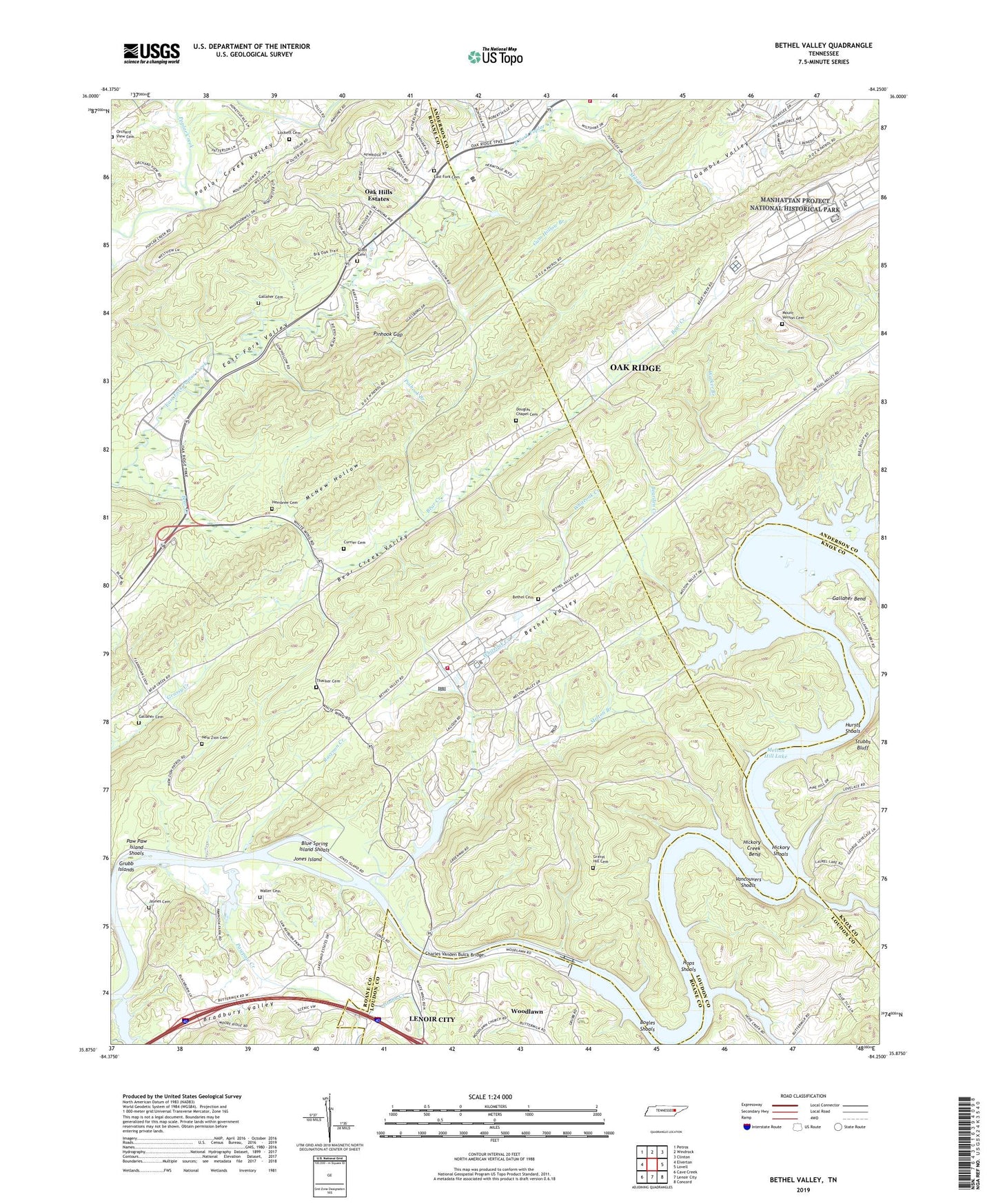
Bethel Valley Tennessee US Topo Map
Couldn't load pickup availability
2019 topographic map quadrangle Bethel Valley in the state of Tennessee. Scale: 1:24000. Based on the newly updated USGS 7.5' US Topo map series, this map is in the following counties: Roane, Anderson, Loudon, Knox. The map contains contour data, water features, and other items you are used to seeing on USGS maps, but also has updated roads and other features. This is the next generation of topographic maps. Printed on high-quality waterproof paper with UV fade-resistant inks.
Quads adjacent to this one:
West: Elverton
Northwest: Petros
North: Windrock
Northeast: Clinton
East: Lovell
Southeast: Concord
South: Lenoir City
Southwest: Cave Creek
Contains the following named places: Acme School, Bear, Bear Creek, Bearden Creek, Bethel Cemetery, Bethel Valley, Blue Spring Island Shoals, Bogles Shoals, Bradbury Valley, Burns Mill, Buttermilk Shores, Caney Creek, Charles Vanden Bulck Bridge, City of Oak Ridge, Clinch View Church, Commissioner District 4, Commissioner District 6, Cumberland Church, Currier Cemetery, Douglas Chapel Cemetery, East Fork Cemetery, East Fork Church, East Fork Ridge, Ethel, Fanny Knob, Gallaher Bend, Gallaher Cemetery, Gamble Valley, George Jones Memorial Church, Gravel Hill Cemetery, Gravel Hill School, Grubb Creek, Grubb Islands, Gum Hollow Branch, Haw Ridge, Hembree Cemetery, Hickory Creek, Hickory Creek Bend, Hickory Creek Park, Hickory Shoals, Hood Ridge, Hope Creek, Hope Creek Colony, Hops Shoals, Hursts Shoals, Jaynes Cemetery, Jones Island, Leedom, Lockett Cemetery, Macedonia Church, McKinney Ridge, McNew Hollow, Melton Branch, Melton Hill, Melton Hill Dam, Melton Hill Dam Recreation Area, Mill Branch, Mount Vernon Cemetery, Mount Zion Baptist Church, Mountain View School, New Bethel Church, New Zion Cemetery, New Zion Church, Oak Hills Estates, Oak Ridge Fire Department Station 1, Oak Ridge Golf and Country Club, Oak Ridge National Laboratory Fire Department, Oak Valley Baptist Church, Orchard View Cemetery, Paw Paw Island Shoals, Pawpaw Creek, Pinhook Branch, Pinhook Gap, Raccoon Creek, Scarboro Church of Christ, Scott Cemetery, Selkirk, South Hills Golf Course, Stubbs Bluff, Thacker Cemetery, United States Atomic Energy Commission, Vancouvers Shoals, Walker Branch, Waller Cemetery, Wallers Ferry, Wheat, White Wing Ferry, Whiteoak Creek, Whiteoak Dam, Williams Ferry, Woodlawn, Woodlawn Church, ZIP Code: 37830