MyTopo
Concord Tennessee US Topo Map
Couldn't load pickup availability
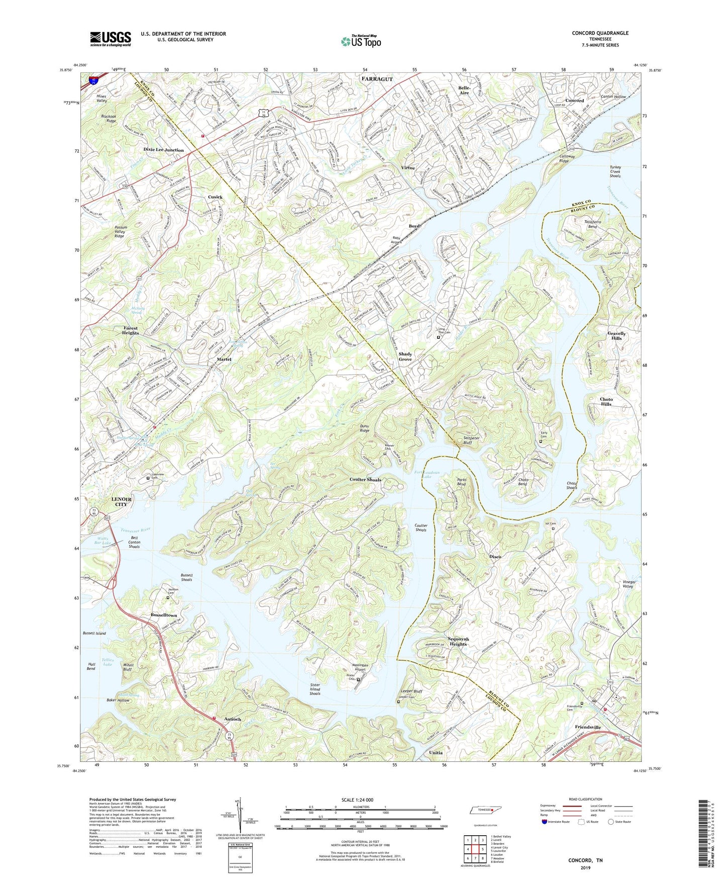
2022 topographic map quadrangle Concord in the state of Tennessee. Scale: 1:24000. Based on the newly updated USGS 7.5' US Topo map series, this map is in the following counties: Loudon, Knox, Blount. The map contains contour data, water features, and other items you are used to seeing on USGS maps, but also has updated roads and other features. This is the next generation of topographic maps. Printed on high-quality waterproof paper with UV fade-resistant inks.
Quads adjacent to this one:
West: Lenoir City
Northwest: Bethel Valley
North: Lovell
Northeast: Bearden
East: Louisville
Southeast: Binfield
South: Meadow
Southwest: Loudon
This map covers the same area as the classic USGS quad with code o35084g2.
Contains the following named places: Aichton Memorial Baptist Church, Antioch, Antioch Baptist Church, Audubon Hills, Baker Hollow, Beals Chapel, Bell Canton Shoals, Belle-Aire, Big Island, Booth Chapel, Boyd, Boyd School, Burnett School, Bussell Shoals, Busselltown, Busselltown School, Calloway Island, Calloway Ridge, Cane Island, Canton Hollow, Cedar Hills, Cedar Hills Golf and Country Club, Chota Shoals, Choto Bend, Choto Church, Choto Estates, Choto Hills, Choto Marina, City of Friendsville, Cloyd Creek, Commissioner District 5, Commissioner District 6, Concord, Concord Dock, Concord Park, Concord Quarry, Concord School, Concords Woods, Coulter Shoals, Cusick, Disco, Dixie Lee Baptist Church, Dixie Lee Junction, Dry Creek, Duff Spring, Dunn Ridge, Earley Island, Early Cemetery, Ebb and Flow Spring, Ford, Forest Heights, Fork Creek, Fort Loudon Estates, Fort Loudoun Dam, Fort Loudoun Lake, Fox Den, Friends Church, Friendsville, Friendsville Academy, Friendsville Cemetery, Friendsville Church, Friendsville Elementary School, Friendsville High School, Friendsville Post Office, Friendsville Volunteer Fire Department, Gallagher Creek, Gravelly Hills, Greenback Fire and Rescue Station 3, Hardin Estates, Hardin Spring, Highland Hills, Highland Hills Church of God, Holder Branch, Ish Cemetery, Ish Creek, Ishs Fort, J Carmichael Greer Bridge, Jackson Cemetery, Keener Cemetery, Kingsgate, Knoxville YMCA Camp, Lakeview Cemetery, Lee Heights Church, Lee Spring, Leeper Bluff, Leeper Cemetery, Leepers Ferry, Lenoir City Marina, Lenoir City Park, Little Turkey Creek, Long Tom Cemetery, Loudon County Fire Rescue Station 3 - Martel, Macs Dock, Martel, Martel Church, Martel Estates, Martel Estates East, Martel School, Massingale Airport, McNeely Spring, McReynolds Island, Mizell Bluff, Mizell Spring, Muddy Creek, Muddy Creek School, Noah's Ark Farm, North Fork Turkey Creek, Norton Islands, Parks Bend, Parks Ferry, Point Harbor, Possum Valley Ridge, Prater Cemetery, Praters Ferry, Raby Airpark, Rio Vista, Rural - Metro Fire Department Station 44, Saltpeter Bluff, Scenic Point Estates, Sequoyah Heights, Shady Grove, Shady Grove Church, Sinking Creek, Sister Island Shoals, Sister Islands, Smoky Landing Dock, South Holston Church, Taliaferro Bend, Taliaferro Island, Tom Carson Spring, Town of Farragut, Turkey Creek, Turkey Creek Shoals, Union Church, Union Valley School, Vinegar Valley, Virtue, Virtue Church, Waterhaven, Watershaw, Wesleyan School, Yarberry Peninsular Recreation Area, ZIP Codes: 37772, 37934