MyTopo
Lovell Tennessee US Topo Map
Couldn't load pickup availability
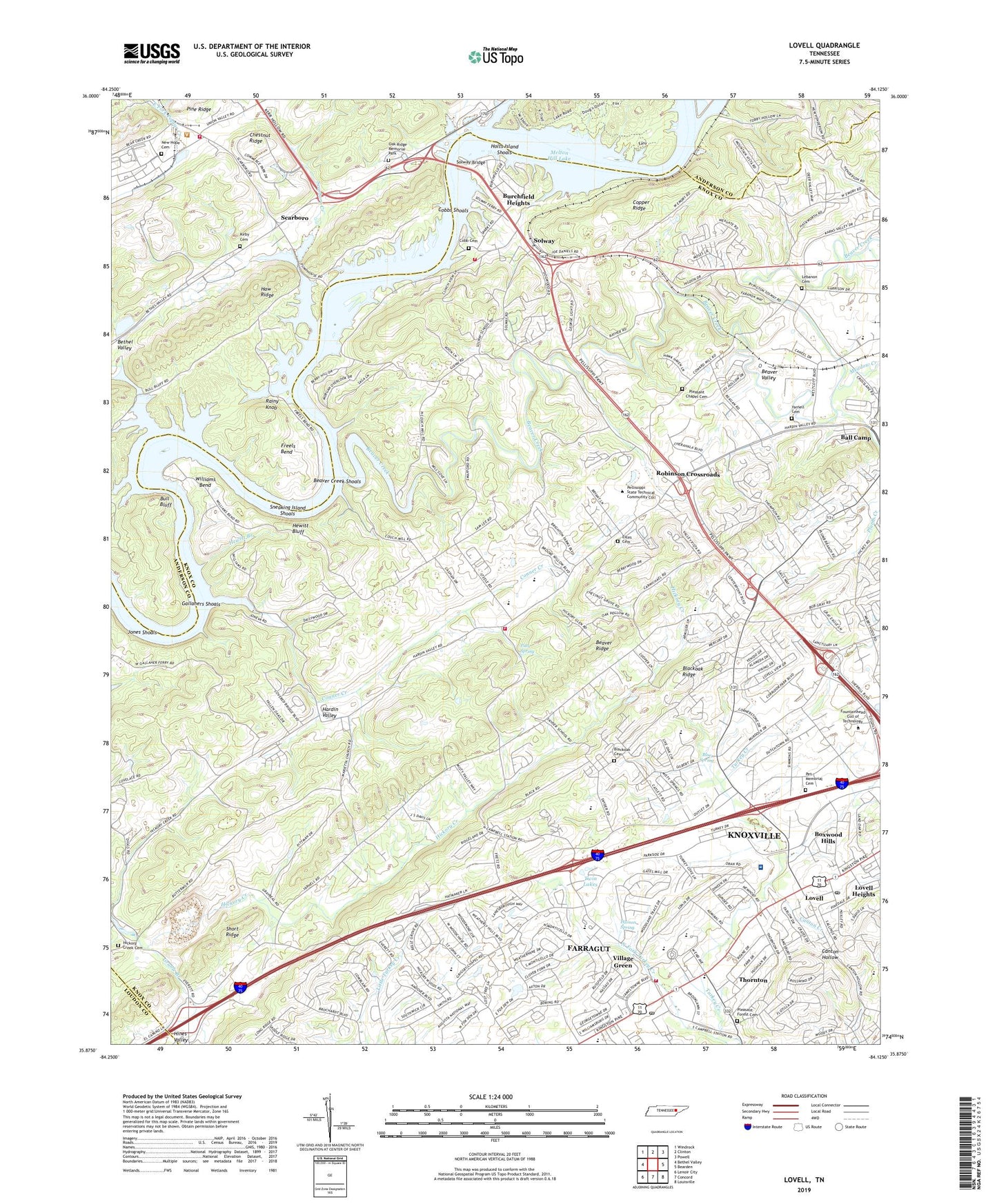
2022 topographic map quadrangle Lovell in the state of Tennessee. Scale: 1:24000. Based on the newly updated USGS 7.5' US Topo map series, this map is in the following counties: Knox, Anderson, Loudon. The map contains contour data, water features, and other items you are used to seeing on USGS maps, but also has updated roads and other features. This is the next generation of topographic maps. Printed on high-quality waterproof paper with UV fade-resistant inks.
Quads adjacent to this one:
West: Bethel Valley
Northwest: Windrock
North: Clinton
Northeast: Powell
East: Bearden
Southeast: Louisville
South: Concord
Southwest: Lenoir City
This map covers the same area as the classic USGS quad with code o35084h2.
Contains the following named places: Amber Meadows, Baptist Hospital West, Beaver Creek, Beaver Creek Estates, Beaver Creek Shoals, Beaver Valley, Blackoak Cemetery, Blue Spring, Boxwood Hills, Branch Hill Church, Bull Bluff, Bullrun Creek, Burchfield Heights, Byrd Chapel, Byrds Chapel Wesleyan Methodist Church, Campbell Station, Canton Creek, Carbide Park, Chestnut Grove School, Cobb Cemetery, Cobbs Shoals, Commissioner District 6, Community Church, Concord Church, Concord Division, Concord Post Office, Conner Creek, Couch Ford, District 9, Estes Cemetery, Fairview Church, Fairview School, Farragut, Farragut Christian Church, Farragut Church, Farragut High School, Farragut Intermediate School, Farragut Middle School, Farragut Post Office, Farragut Primary School, Farragut Towne Square Shopping Center, Fiesta Farm, Freels Bend, Gallaher Ferry, Gallahers Shoals, Grable Branch, Grassy Valley Church, Grigsby Chapel, Guinn Road Park, Hardin Valley, Hardin Valley Division, Hardin Valley School, Herron Spring, Hewitt Bluff, Hewitt Branch, Hickory Creek Cemetery, Hickory Woods, Hines Valley Church, Holt Island, Holts Island Shoals, Hudson Grove Church, Jones Island, Jones Shoals, Karns Fire Department Station 3, Karns Volunteer Fire Department Station 2, Kingston Pike Church, Kirby Cemetery, Lebanon Cemetery, Lebanon Church, Lee Ford, Lovell, Lovell Heights, Lovell Road Mobile Home Park, Marietta Church, McCoy Branch, Meadow Creek, Medford Chapel, Melton Hill Community Center, Melton Hill Lake, Melton Hill Park, Mount Pleasant Church, New Hope Cemetery, New Hope Church, Oak Ridge Memorial Park, Pet Memorial Cemetery, Pitts Spring, Pleasant Chapel, Pleasant Chapel Cemetery, Pleasant Forest Cemetery, Pleasant Forest Presbyterian Church, Plum Creek, Plumb Creek, Providence Church, Rainy Knob, Robinson Crossroads, Rural - Metro Fire Department Station 41, Rural / Metro Ambulance Knox County, Scarboro, Scarboro Creek, Scarboroughs Ferry, Short Ridge, Smith Grove Church, Sneaking Island, Sneaking Island Shoals, Snyder School, Solway, Solway Bridge, Solway Church, Solway School, Station West, Stoney Point Church, Sweet Briar, Thornton, Turkey Creek Medical Center, Twin Lakes, Twin Springs, Unity Church, University of Tennessee Agriculture Experiment Station, University of Tennessee Agriculture Research Laboratory, University of Tennessee Arboretum, Village Green, Volunteer Village, WETQ-FM (Oak Ridge), Wexford Downs, Williams Bend, Wood Creek West, Woodchase, Woodland Trace, Y12 Fire Department, Yarnell Cemetery, ZIP Codes: 37931, 37932