MyTopo
Boyds Creek Tennessee US Topo Map
Couldn't load pickup availability
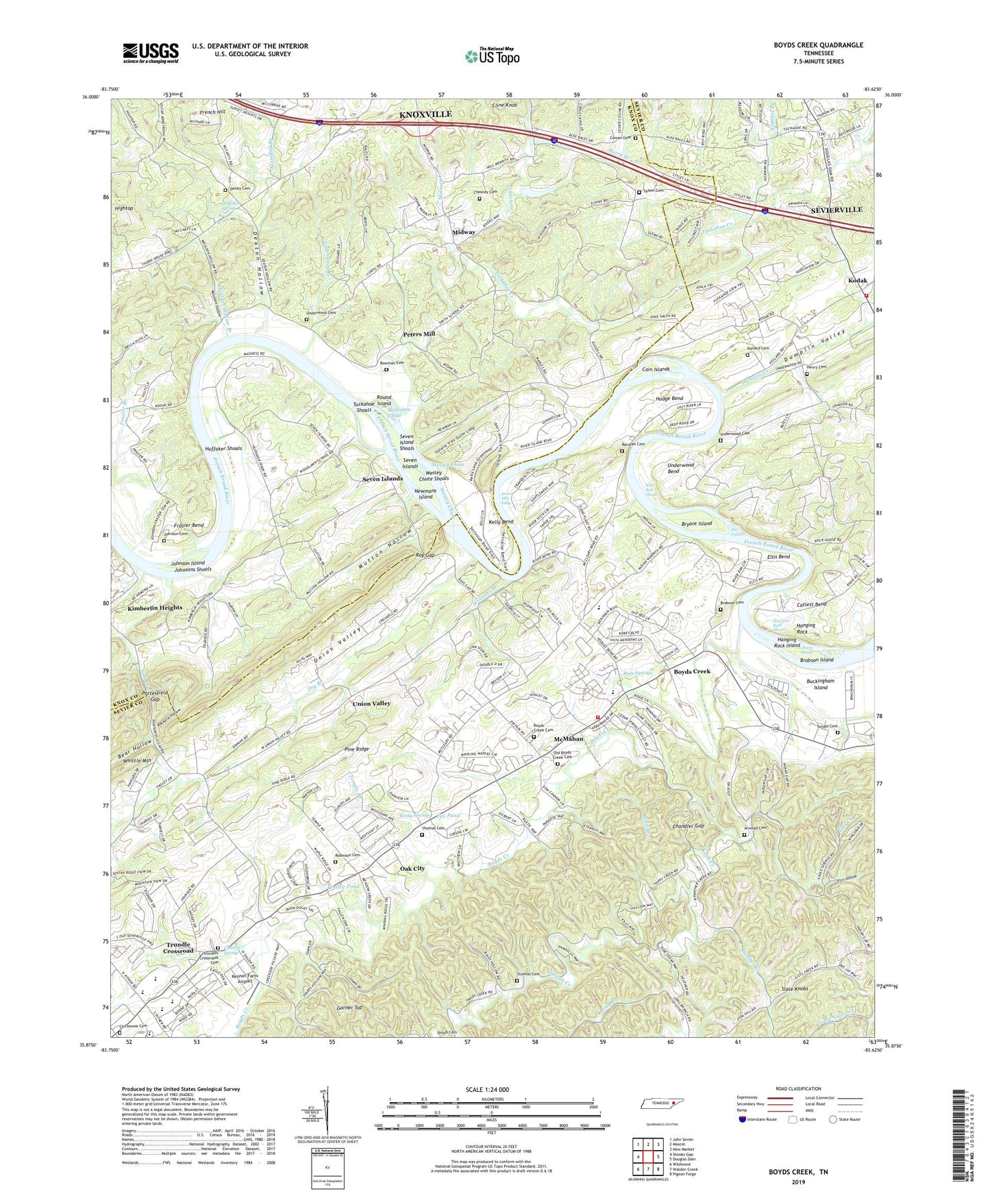
2019 topographic map quadrangle Boyds Creek in the state of Tennessee. Scale: 1:24000. Based on the newly updated USGS 7.5' US Topo map series, this map is in the following counties: Sevier, Knox. The map contains contour data, water features, and other items you are used to seeing on USGS maps, but also has updated roads and other features. This is the next generation of topographic maps. Printed on high-quality waterproof paper with UV fade-resistant inks.
Quads adjacent to this one:
West: Shooks Gap
Northwest: John Sevier
North: Mascot
Northeast: New Market
East: Douglas Dam
Southeast: Pigeon Forge
South: Walden Creek
Southwest: Wildwood
Contains the following named places: Armstrong School, Arwood Cemetery, Bear Hollow, Beech Springs Baptist Church, Beech Springs Division, Berry Branch, Bethel Church, Bethel School, Bowman Cemetery, Boyds Creek, Boyds Creek Cemetery, Boyds Creek Church, Boyds Creek School, Brabson Cemetery, Brabson Ferry, Brabson Island, Bryant Island, Buckingham Island, Cain Islands, Calf Branch, Callans Pond, Catlett Bend, Cedar Rock Lake, Chandler Gap, Charis Lake, Chesney Cemetery, Chilhowee Cemetery, Chilhowee Division, Clarks School, Claxton Spring, Commissioner District 6, Cowan Cemetery, Dailey Cemetery, Davis Shoals, Deaton Hollow, Dry Branch, Dumplin Creek, Dumplin Valley, East Stony Point School, Ebenezer Church, Ellis Bend, Ellis Hollow, First Chilhowee Church, Flat Creek, Fox Pond, Frazier Bend, French Hill, Gap Creek, Gapcreek, Garner Top, Golden Valley Lake, Hanging Rock, Hanging Rock Island, Hanging Rock Shoals, Happy Creek, Harrison Chilhowee Academy, Henry Cemetery, Hicks Crossing, Hightop, Hightop Church, Hodge Bend, Huffaker Ferry, Huffaker Shoals, Huffaker Spring, Hyletts Ferry, Island View School, John Sevier Monument, Johnson Cemetery, Johnson Island, Johnsons Shoals, Kelly Bend, Kenner Farm Airport, Kinners Branch, Knight School, Knob Creek, Kodak, Learn Pond, Limestone Creek, Little Guess Creek, Long Branch, Manifold Branch, McMahan, Midway, Midway Creek, Midway School, Moulden Hollow, Moulden Hollow Branch, Mutton Hollow, Newmans Island, Northview / Kodak Fire Department, Oak City, Oak City Baptist Church, Old Boyds Creek Cemetery, Open-Door Chapel, Panther Creek, Payne School, Paynes Temple School, Peters Mill, Pine Ridge, Pollard Cemetery, Porterfield Gap, Rackard Hollow, Randies Cemetery, Ray Gap, Ridgeway Methodist Church, Robinson Cemetery, Rock Sjprings, Rocky Springs, Rocky Springs Church, Round Island, Salem Cemetery, Salem Church, Seven Island Shoals, Seven Islands, Seven Islands Church, Seven Islands Methodist Church, Seven Mile Eddy, Seymour, Seymour High School, Seymour Middle School, Seymour Primary School, Seymour Volunteer Fire Department Station 5, Slate Knobs, Smith School, Stony Point, Stony Point Church, Temple Branch, Temple School, The Gallops, Thomas Cemetery, Tinsley Pond, Tri-C Farms, Trundle Crossroad, Trundle Family Cemetery, Trundles Crossroads Cemetery, Tuckahoe Chute, Tuckahoe Creek, Tuckahoe Shoals, Underwood, Underwood Bend, Underwood Branch, Underwood Cemetery, Underwood School, Union Valley, Union Valley Church, Union Valley School, Vista Farms, Walkers Landing, Wesley Chute, Wesley Chute Shoals, Whittle Mountain, Wild Bull Shoals, Williams Branch, Woodlawn School