MyTopo
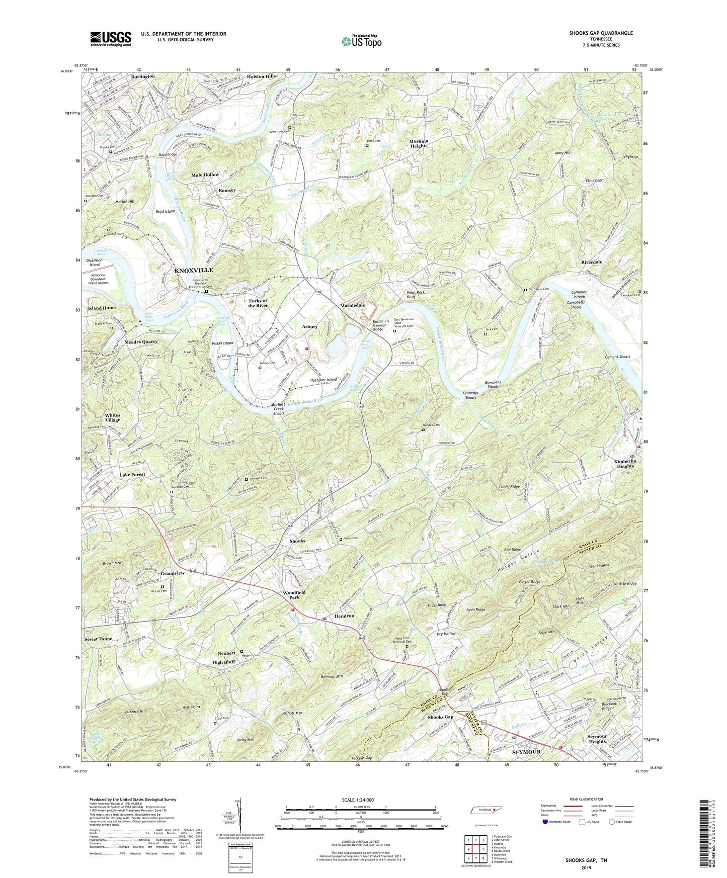
Shooks Gap Tennessee US Topo Map
Couldn't load pickup availability
2022 topographic map quadrangle Shooks Gap in the state of Tennessee. Scale: 1:24000. Based on the newly updated USGS 7.5' US Topo map series, this map is in the following counties: Knox, Sevier, Blount. The map contains contour data, water features, and other items you are used to seeing on USGS maps, but also has updated roads and other features. This is the next generation of topographic maps. Printed on high-quality waterproof paper with UV fade-resistant inks.
Quads adjacent to this one:
West: Knoxville
Northwest: Fountain City
North: John Sevier
Northeast: Mascot
East: Boyds Creek
Southeast: Walden Creek
South: Wildwood
Southwest: Maryville
This map covers the same area as the classic USGS quad with code o35083h7.
Contains the following named places: Anderson Elementary School, Armstrong Branch, Armstrong Cemetery, Asbury, Asbury Cemetery, Asbury Quarry, Asbury School, Asbury United Methodist Church, Atlas Quarry, Bays Mountain Church, Beaman Lake, Beaman Lake Dam, Bean Ridge, Bells Chapel, Bethel Church, Betsy Mountain, Beulah United Methodist Church, Bower Field, Bowman Mountain, Bowmans Shoals, Boyd Bridge, Boyd Ferry, Boyd Island, Brooks Road Church, Brown Mountain, Burnett Creek, Burnett Creek Church, Burnett Creek Shoals, Buzzard Hill, Campbell Cemetery, Campbell Islands, Campbells Shoals, Case Mountain, Cement Mill Creek, Cement Shoals, Clark Mountain, Clarks Creek, Colonial Heights United Methodist Church, Commissioner District 9, Crossfield, Cruze Cemetery, Cruze Creek, Delrose Church, Dickinson Island, Doctor J H Gammon Bridge, Dora Kennedy School, Dry Hollow, Dunn Cemetery, East Tennessee State Veterans Cemetery, Eastern State Hospital Farm, Eastern State Wildlife Management Area, Fair Garden Elementary School, Finger Ridge, Flint Gap, Flint Gap Church, Forest Grove Church, Forks of the River, Forks of the River Industrial Park, Foster Chapel Baptist Church, Frazier Branch, French Broad River, French Broad Shoals, Fruits Island Ford, Galilee Church, Gap Creek Church, Gap Creek Elementary School, Glass Knob, Gloria Dei Church, Goose Neck Shoals, Grandview, Gray Eagle Quarry, Gray Knox Quarry, Graystone Quarry, Greater Warner Tabernacle African Methodist Episcopal Church, Hasppy Hollow, Hendron, Hendrons United Methodist Church, High Bluff, High Point, Hillcrest Church, Hines Creek, Holiness Church, Holly Hills Memorial Park, Holston Hills, Holston Hills Golf and Country Club, Holston Quarry, Holston River, Hoze Mountain, Huckleberry Springs, Huckleberry Springs United Methodist Church, Huffaker Island, Island Home Assembly of God Church, Jack Cemetery, Jacks Mill, Johnson Bible College, Johnson Cemetery, Johnson Hollow, Johnson Road, Jones Quarry, Jumping Moses Shoal, Kennedys Shoals, Kimberlin Heights, Kimberlin Heights Church, Kimberlin Heights Post Office, Knoxville Downtown Island Airport, Lake Forest, Lebanon Church, Lebanon In The Fork Presbyterian Cemetery, Lowes Landing Strip, Lundy Ridge, Maranatha Church, Marbledale, Marbledale Church, Marbledale Quarry, Mary Hill, McCall Branch, McCall Cemetery, McDonald Drive Church of Christ, McNutt Cemetery, McNutt Shoals, Meade School, Meades Quarry, Meadow View Church, Meridian Cemetery, Meridian Church, Mill Shoals, Monday Cemetery, Moshina Heights, Mount Harmony Church, Mule Hollow, Neubert, Neubert Cemetery, Neubert Post Office, Neubert Quarry, Neubert School, Neubert Springs, Neubert Sulphur Springs, New Hopewell, New Hopewell Baptist Church, New Hopewell Elementary School, New Prospect Church, Nichols Mountain, Old Salem Cemetery, Paint Rock Bluff, Paint Rock Shoals, Pattys Shoals, Pennyroyal Shoals, Perry Cemetery, Pickel Island, Pickens Gap, Piney Grove Church, Pitner, Pratt Branch, Ramsey, Ramsey Ferry, Ramsey Heights Baptist Church, Ramsey School, Red Ridge, Riverdale, Riverdale Baptist Church, Riverdale Church, Riverdale Ferry, Riverdale School, Riverview Church, Robert L Huff School, Rural - Metro Fire Department Station 27, Sand Branch, Sand Branch United Methodist Church, Sarah Moore Greene Elementary School, Sawmill Run, Sevier Home, Sevier Home School, Seymour Census Designated Place, Seymour Heights, Seymour Post Office, Seymour Volunteer Fire Department Station 1, Seymour Volunteer Fire Department Station 2, Seymour Volunteer Fire Department Station 6, Shook Cemetery, Shooks, Shooks Gap, Sinking Springs School, Sixmile Branch, Soap Dam Creek, Stanton Cemetery, Swanpond Creek, Tadpole Quarry, Thrashers Quarry, Tipton Station Church, Toll Creek, Trinity Baptist Church, Union Cemetery, Valley Grove, Valley Grove Church, Victoria Quarry, Walnut Spring, White School, Whites Village, Whittle Ridge, Williams Cemetery, Williams Quarry, Woodfield Park, WRJZ-AM (Knoxville), ZIP Codes: 37914, 37920