MyTopo
Pigeon Forge Tennessee US Topo Map
Couldn't load pickup availability
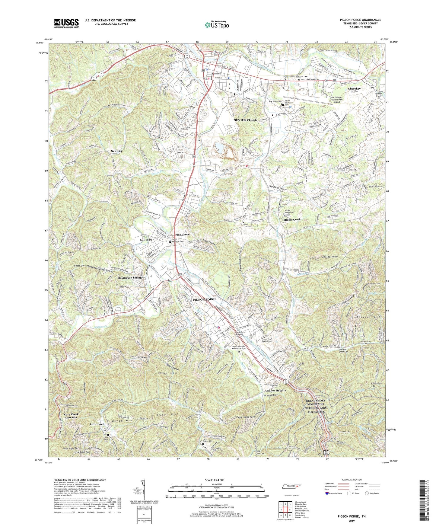
2022 topographic map quadrangle Pigeon Forge in the state of Tennessee. Scale: 1:24000. Based on the newly updated USGS 7.5' US Topo map series, this map is in the following counties: Sevier. The map contains contour data, water features, and other items you are used to seeing on USGS maps, but also has updated roads and other features. This is the next generation of topographic maps. Printed on high-quality waterproof paper with UV fade-resistant inks.
Quads adjacent to this one:
West: Walden Creek
Northwest: Boyds Creek
North: Douglas Dam
Northeast: Shady Grove
East: Richardson Cove
Southeast: Mount Le Conte
South: Gatlinburg
Southwest: Wear Cove
This map covers the same area as the classic USGS quad with code o35083g5.
Contains the following named places: Beech Grove Cemetery, Bench Mountain, Big Ridge Branch, Birchfield Ford, Cain Hollow, Caney Creek, Caney School, Caton Branch, Cherokee Hills, City of Pigeon Forge, Commissioner District 4, Commissioner District 5, Conner Heights, Conner Heights Baptist Church, Cove Creek Cascades, Davids Knob, Devils Branch, Dry Fork, East Fork Little Pigeon River, Fellowship Baptist Church, First Baptist Church of Sevierville, First Presbyterian Church, First United Methodist Church, Fort Sanders Sevier Medical Center, Gatlinburg City Dump, Gatlinburg Golf Course, Gatlinburg-Pigeon Forge Airport, Gibson Hollow, Gnatty Branch, Goose Gap, Grindstone Ridge, Gum Stand Church, Henderson Chapel, Henderson Springs, Henderson Springs Hollow, Hodsden Bridge, Hurst Chapel, Hurst Chapel Cemetery, King Branch, Large Ford, Large Island, Laurel Lick Branch, Laurel Lick School, Little Cove, Little Cove Baptist Church, Little Cove Cemetery, Little Cove Creek, Little Cove Gap, Little Cove School, Lost Branch, Marshall Grove Church, Mathis Hollow, McClure Ford, McCookville, McCookville School, McMahan Cemetery, McMahan Chapel Cemetery, Middle Creek, Middle Creek Cemetery, Middle Creek School, Middle Creek United Methodist Church, Mill Creek, Mount Zion, Mount Zion Baptist Church, Mount Zion Cemetery, Mountain View School, Murphy Branch, Murphy Collegiate Institute, New Era, New Era Baptist Church, New Era School, New Salem Cemetery, Norton Branch, Ogle Chapel, Painters Knob, Patterson Lead, Pigeon Forge, Pigeon Forge Baptist Cemetery, Pigeon Forge Community Center, Pigeon Forge Fire Department, Pigeon Forge Methodist Cemetery, Pigeon Forge Middle School, Pigeon Forge Police Department, Pigeon Forge Post Office, Pigeon Forge Primary School, Pine Grove, Pine Grove School, Pine Mountain, Pleasant View School, Possum Hollow, Reagantown, Rivers Edge Shopping Center, Seaton Branch, Sevier County, Sevier County Cemetery, Sevier County Courthouse, Sevier County EMS, Sevier County High School, Sevier County Home, Sevier County Sheriff's Office, Sevier Plaza Shopping Center, Sevierville, Sevierville Division, Sevierville Fire Department Headquarters, Sevierville Fire Department Station 2, Sevierville Middle School, Sevierville Police Department, Sevierville Post Office, Sevierville Primary School, Sharp Hollow, Shiloh Memorial Cemetery, Slay Bacon Hollow, Smoky Mountain Memory Gardens, Spring Hollow, Sugar Camp Knob, Sugar Hollow, Sweat Hill, Tilda High Top, Tilda Ridge, Todd Branch, Waldens Creek, Waldens Creek Baptist Church, Webb Branch, West Fork Gists Creek, West Prong Little Pigeon River, Williams Cemetery, Williamsburg, Williamsburg Cemetery, Williamsburg Church, Williamsburg School, Witt Hollow, WSEV-AM (Sevierville), ZIP Codes: 37862, 37863