MyTopo
Campbellsville Tennessee US Topo Map
Couldn't load pickup availability
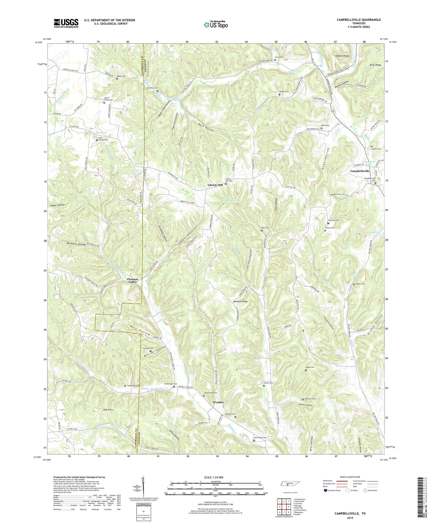
2022 topographic map quadrangle Campbellsville in the state of Tennessee. Scale: 1:24000. Based on the newly updated USGS 7.5' US Topo map series, this map is in the following counties: Giles, Lawrence. The map contains contour data, water features, and other items you are used to seeing on USGS maps, but also has updated roads and other features. This is the next generation of topographic maps. Printed on high-quality waterproof paper with UV fade-resistant inks.
Quads adjacent to this one:
West: Ethridge
Northwest: Summertown
North: Sandy Hook
Northeast: Lynnville
East: Milky Way
Southeast: Pulaski
South: Bodenham
Southwest: Lawrenceburg
This map covers the same area as the classic USGS quad with code o35087c2.
Contains the following named places: Anderson Creek, Baker Cemetery, Ball Hollow, Beckham Hollow, Bonee Branch, Briar Ridge, Brownlow Creek, Buck Hollow, Campbellsville, Campbellsville Cemetery, Campbellsville School, Campbellsville Spring, Carpenter Hollow, Carter Cemetery, Clifton Cemetery, Cloverdale Church, Commissioner District 3, County Line Church, Dickey Hollow, Dry Weakley Creek, Dupree Hollow, Factory Creek, Falls Hollow, Faull Branch, Fautt Branch, Giles County Fire and Rescue Department - Rose Hill, Gimlet Creek, Greenwood Cemetery, Greenwood Church, Helton Cemetery, James Hollow, Jasper Field Hollow, Jones Hollow, Kimbrough Cemetery, Knox Hollow, Liberty Hill, Liberty Hill Baptist Church, Liberty Hill Cemetery, Lucy Cemetery, Mack Branch, Marcella, Marcella Cemetery, Marcella Falls, Marcella Falls Church, Marcella Falls Spring, May Cemetery, Mint Spring, Mint Spring Branch, Mint Spring Cemetery, Morrow Hollow, Mount Horeb Cemetery, Mount Horeb Church, Mount Horeb School, Muckle Branch, New Hope Baptist Church, New Hope Cemetery, Nobbin Ridge, Oak Hill, Oak Hill School, Old Brick Academy, O'Rear Hollow, Owen School, Parker Cemetery, Pleasant Valley, Pleasant Valley School, Poplar Spring Hollow, Rhea Branch, Rhea Cemetery, Rock Spring Branch, Rock Spring Church, Rose Branch, Rose Hill Cemetery, Rose Hill Church, Rose Hill School, Saint Matthews Church, Salem Cemetery, Salem Church, Seven, Shuler Branch, Stafford Cemetery, Union Valley Church, Vater, Weakley, Weakly School, Wet Weakley Creek, Whitson Cemetery, Whitson Hollow, Whitsons Creek, Womble Ridge, Wood Cemetery, Woodard Hollow, Yarbrough Cemetery, Yokley Cemetery, Yokley Creek, Zuccarello Hollow