MyTopo
Church Hill Tennessee US Topo Map
Couldn't load pickup availability
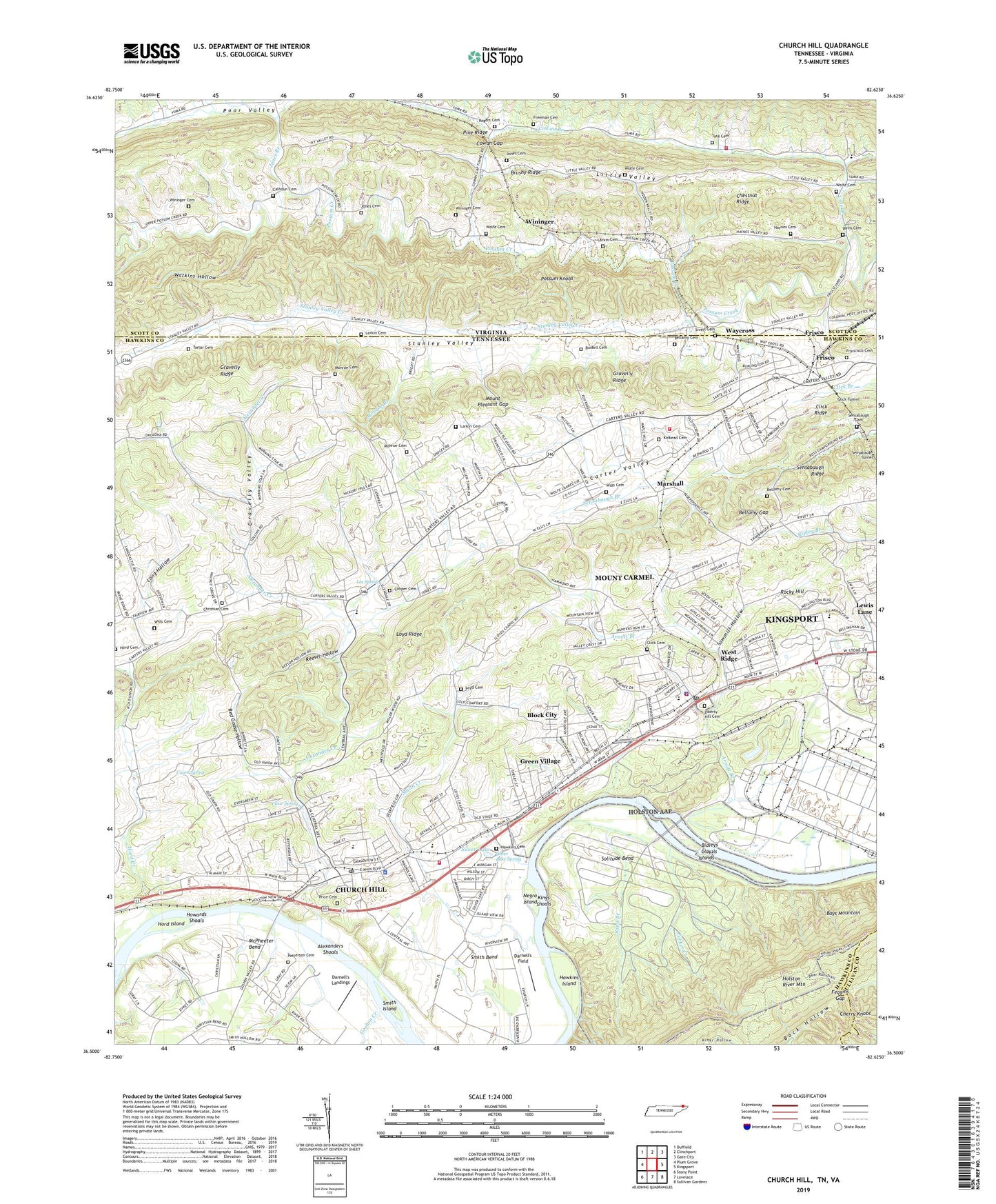
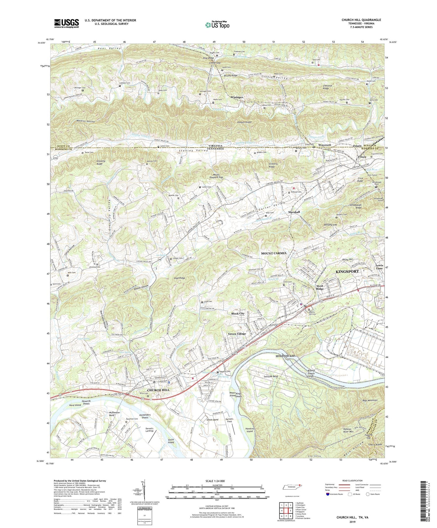
2019 topographic map quadrangle Church Hill in the states of Tennessee, Virginia. Scale: 1:24000. Based on the newly updated USGS 7.5' US Topo map series, this map is in the following counties: Hawkins, Scott, Sullivan. The map contains contour data, water features, and other items you are used to seeing on USGS maps, but also has updated roads and other features. This is the next generation of topographic maps. Printed on high-quality waterproof paper with UV fade-resistant inks.
Quads adjacent to this one:
West: Plum Grove
Northwest: Duffield
North: Clinchport
Northeast: Gate City
East: Kingsport
Southeast: Sullivan Gardens
South: Lovelace
Southwest: Stony Point
Contains the following named places: Alexander Creek, Alexanders Shoals, Allandale, Allandale Mansion, Arnott Branch, Bays Cove, Bellamy Cemetery, Bellamy Gap, Bidleys Shoals, Block City, Bradshaw Chapel, Bradshaw Mill, Brookshire Hills, Brushy Ridge, Bussell Cemetery, Calhoun Cemetery, Cameron Church, Carters Valley School, Carter's Valley Volunteer Fire Department Station 1, Cartersville, Cate Branch, Catron Chapel, Center Valley Church, Cherry Knobs, Chestnut Ridge, Christian Cemetery, Church Hill, Church Hill Church, Church Hill Division, Church Hill Elementary School, Church Hill Fire Department Station 1, Church Hill Middle School, Church Hill Police Department, Church Hill Post Office, Church Hill Rescue Squad, Church Hill Shopping Center, City of Church Hill, Clay Islands, Clear Spring, Cleveland School, Click Cemetery, Click Ridge, Click Tunnel, Commissioner District 1, Cooper Cemetery, Cowan Branch, Cowan Branch Church, Cowan Gap, Cowan School, Curry Ford, Darnell's Field, Darnell's Landings, Davis Cemetery, District 1, Feagins Gap, Francisco Cemetery, Freeman Cemetery, Frisco, Goshen Creek, Grange Hall School, Grange Hall United Methodist Church, Gravelly Ridge, Gravelly Valley, Green Village, Grimm School, Hawkins Cemetery, Hawkins Island, Haynes Cemetery, Holston Army Ammunition Plant, Holston Army Ammunition Plant Fire Department, Holston River Mountain, Hord Cemetery, Hord Creek, Hord Island, Hord Mill, Howards Shoals, Johnson Store, Jones Branch, Jones Cemetery, Kingsport University Center, Kinkaid Estates, Kinkead Cemetery, Larkin Cemetery, Lebanon Church, Lee Spring, Lees School, Lewis Lane, Liberty Hill Cemetery, Liberty Hill Church, Liberty Hill School, Little Valley, Long Hollow, Loyd Cemetery, Loyd Ridge, Loyd School, Marshall, Marshall Estates, McPheeter Bend, Monroe Branch, Monroe Cemetery, Morning Star Church, Mount Carmel, Mount Carmel Church, Mount Carmel Division, Mount Carmel Library, Mount Carmel Park, Mount Carmel Police Department, Mount Carmel Post Office, Mount Carmel Shopping Center, Mount Carmel Volunteer Fire Department, Mount Mitchell Church, Mount Pleasant Church, Mount Pleasant Gap, Mountain Springs, Mountain View Church, Negro Island, Oak Grove Baptist Church, Old Union Church, Parker Creek, Patterson Cemetery, Pattersons Mill, Pine Ridge, Ponderosa Estates, Possum Knobs, Price Cemetery, Red Goose Hollow, Reeser Hollow, Rices Mill, Rocky Hill, Rocky Hill School, Rogers Cemetery, Ross Camp Ground United Methodist Church, Ross Camp School, Ross Campground, Sand Branch, Sawmill Hollow, Sensabaugh Cemetery, Sensabaugh Ridge, Seven Oaks, Silver Lake, Silver Lake Spring, Sivert Cemetery, Smith Bend, Smith Creek, Smith Island, Solitude Bend, Solitude Ford, Solitude School, Stanley Valley Creek, Tartar Cemetery, Tate Cemetery, Town of Mount Carmel, Union Spring, Valley View Baptist Church, Valley View School, Vicars Chapel, Volunteer High School, Watkins Hollow, Waycross, Weber City Volunteer Fire Department Station 2, West Ridge, Wills Cemetery, Wininger, Wininger Cemetery, WMCH-AM (Church Hill), Wolfe Cemetery, ZIP Codes: 37642, 37645