MyTopo
East Ridge Tennessee US Topo Map
Couldn't load pickup availability
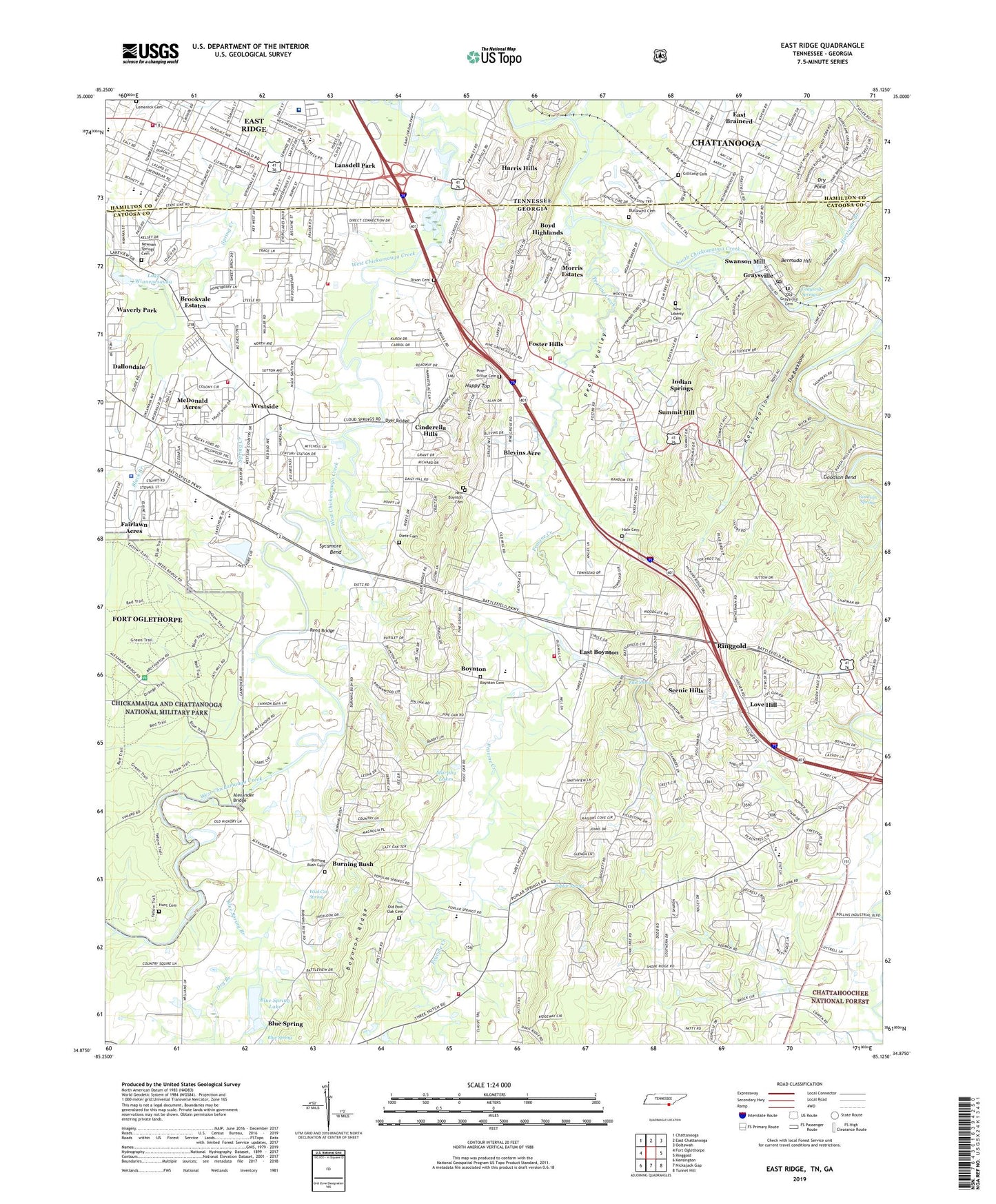
2019 topographic map quadrangle East Ridge in the states of Georgia, Tennessee. Scale: 1:24000. Based on the newly updated USGS 7.5' US Topo map series, this map is in the following counties: Hamilton, Catoosa. The map contains contour data, water features, and other items you are used to seeing on USGS maps, but also has updated roads and other features. This is the next generation of topographic maps. Printed on high-quality waterproof paper with UV fade-resistant inks.
Quads adjacent to this one:
West: Fort Oglethorpe
Northwest: Chattanooga
North: East Chattanooga
Northeast: Ooltewah
East: Ringgold
Southeast: Tunnel Hill
South: Nickajack Gap
Southwest: Kensington
Contains the following named places: Alexander Bridge, Baldwin Monument, Battlefield Elementary School, Battlefield Golf Club and Estates, Battlefield Primary School, Belvoir Terrace, Bermuda Hill, Bible Way Church, Black Branch, Blackwell Cemetery, Blevins Acre, Blue Spring, Blue Spring Branch, Blue Spring Lake, Blue Spring Lake Dam, Boyd Highlands, Boynton, Boynton Baptist Church, Boynton Cemetery, Boynton Elementary School, Boynton Methodist Church, Boynton Ridge Division, Brook Field, Brookvale Estates, Burning Bush, Burning Bush Baptist Church, Burning Bush Cemetery, Burning Bush School, Byrams Ford, Calvary Church, Camp Scott Patterson, Castle Park, Catoosa Church, Catoosa County, Catoosa County Fire Department Station 3, Catoosa County Jail, Catoosa County Sheriff's Office, Catoosa Memorial Gardens, Cinderella Hills, City of East Ridge, City of Fort Oglethorpe, Clearview Church, Daffron Ford, Dafron, Dailey Hill, Dallondale, Dalton Ford, Delray Church, Dietz, Dietz Cemetery, Dixon Cemetery, Dry Branch, Dry Pond, Duncan Park, Duncan Park Church, Dyer Bridge, Dyers Bridge, Dyers Ford, Dyers Mill, East Boynton, East Brainerd, East Ridge Baptist Church, East Ridge Christian Church, East Ridge Church of Christ, EAst Ridge Church of God, East Ridge City Hall, East Ridge Division, East Ridge Elementary School, East Ridge Fire Rescue Department Station 1, East Ridge High School, East Ridge Middle School, East Ridge Police Department, East Ridge Post Office, East Ridge Presbyterian Church, East Ridge Shopping Center, Elise Chapin Wildlife Sanctuary, Ellie Spring, Ellis Spring, Faith Church, Fellowship Baptist Church, Fort Oglethorpe Fire Department Station 2, Fort Oglethorpe Fire Department Station 3, Fort Oglethorpe Police Department, Fort Oglethorpe-Lakeview Division, Foster Hills, Fowlers Ford, Frawley Church, Gateway Church, Gilliland Cemetery, Goodson Bend, Goodson Spring, Graysville, Graysville Church, Graysville Elementary School, Graysville Methodist Church, Graysville Post Office, Graysville Springs, Hale Cemetery, Happy Top, Harris Hills, Helm Monument, Heritage High School, Heritage Middle School, Hunt Cemetery, Hurricane Branch, Hurricane Creek, Indian Springs, Indian Springs Census Designated Place, Indian Springs Church, Irwin Hills, Jays Mill, John Calvin Church, Jones Memorial United Methodist Church, Lake Winnepesauka, Lakeview - Fort Oglethorpe High School, Lamberts Ford, Lansdell Park, Liles Addition, Lomenick Cemetery, Love Hill, Mackey Branch, Mana Estates, Market Place Mall Shopping Center, McBrien Elementary School, McDonald Acres, Midway Church, Mitchell Acres, Morris Estates, Mount Zion Church, Murphy Lakes, New Boynton Cemetery, New Liberty, New Liberty Cemetery, New Liberty Church, Newman Springs Church, Newnan Springs, Newnan Springs Cemetery, Old Fort Estates, Old Graysville Cemetery, Old Mill Trace, Old Post Oak Cemetery, Omega Church, Opeleika, Parkridge East Hospital, Parkway Church, Peavine Creek, Peavine Valley, Philadelphia Baptist Church, Pine Grove Cemetery, Pine Grove Church, Pleasant Grove, Pleasant Grove Church, Pleasant View School, Poplar Spring, Poplar Springs, Poplar Springs Church, Post Oak, Post Oak Church, Post Oak School, Puckett EMS, Reed Bridge, Reeds Ford, Ringgold Bridge, Ringgold Division, Ringgold Elementary School, Ringgold Primary School, Ross Hollow, Saint James Church, Scenic Hills, Scott Memorial Church of God, Shiloh Church, Smith Monument, Spring Creek Elementary School, Spring Creek Road Baptist Church, Summit Hill, Swanson Mill, Sweet Spring, Sycamore Bend, The Backbone, Thedford Ford, Unity Church, Unity School, Walnut Hills, Waverly Park, West Side Elementary School, Westside, Westside Church, Wild Cat Spring, Winfrey House, ZIP Codes: 30726, 30736, 30742, 37412